Deerfield, New York

Last updated

Deerfield, New York
Oneida County New York incorporated and unincorporated areas Deerfield highlighted.svg
Location in Oneida County and the state of New York.
Coordinates: 43°10′28″N75°9′42″W / 43.17444°N 75.16167°W / 43.17444; -75.16167
CountryUnited States
State New York
County Oneida
Government
  Type Town Council
   Town Supervisor Gregory Sacco (D) [1]
   Town Council
Members' List
Area
[2]
  Total33.05 sq mi (85.60 km2)
  Land32.94 sq mi (85.32 km2)
  Water0.11 sq mi (0.28 km2)
Elevation
1,014 ft (309 m)
Population
 (2010)
  Total4,273
  Estimate 
(2016) [3]
4,249
  Density128.98/sq mi (49.80/km2)
Time zone UTC-5 (Eastern (EST))
  Summer (DST) UTC-4 (EDT)
ZIP code
13502
Area code 315
FIPS code 36-19928
GNIS feature ID0978891
Website Town of Deerfield Home Page

Deerfield is a town in Oneida County, New York, United States. The population was 4,273 at the 2010 census.

Contents

The Town of Deerfield is on the eastern border of the county and northeast of the City of Utica.

History

Deerfield was formed from the Town of Schuyler in 1798.

In Walter D. Edmonds' 1936 novel "Drums Along the Mohawk" and the 1939 film of the same name, the story portrays settlers of the New York frontier in the 1700s. The main protagonists (played in the film by Henry Fonda and Claudette Colbert) leave their luxurious home to build a small frontier farm in Deerfield in the Mohawk Valley.

Geography

According to the United States Census Bureau, the town, which lies immediately north of the city of Utica, has a total area of 33.1 square miles (86 km2), of which 32.9 square miles (85 km2) is land and 0.1 square miles (0.26 km2) (0.39%) is water.

The eastern town line is the border of Herkimer County. The New York State Thruway and the Erie Canal pass south of the town. The Mohawk River once formed the southern border of the town but has since been annexed into Utica.

Demographics

Historical population
CensusPop.Note
1800 1,048
1810 1,23217.6%
1820 2,34690.4%
1830 4,18278.3%
1840 3,120−25.4%
1850 2,287−26.7%
1860 2,249−1.7%
1870 2,045−9.1%
1880 2,0821.8%
1890 1,954−6.1%
1900 1,756−10.1%
1910 1,660−5.5%
1920 706−57.5%
1930 98339.2%
1940 1,14716.7%
1950 1,62141.3%
1960 3,554119.2%
1970 4,10415.5%
1980 3,934−4.1%
1990 3,9420.2%
2000 3,909−0.8%
2010 4,2739.3%
2016 (est.)4,249 [3] −0.6%
U.S. Decennial Census [4]

As of the census [5] of 2000, there were 3,906 people, 1,449 households, and 1,146 families residing in the town. The population density was 118.6 inhabitants per square mile (45.8/km2). There were 1,512 housing units at an average density of 45.9 per square mile (17.7/km2). The racial makeup of the town was 98.75% White, 0.59% African American, 0.05% Native American, 0.28% Asian, 0.03% from other races, and 0.31% from two or more races. Hispanic or Latino of any race were 0.72% of the population.

There were 1,449 households, out of which 35.0% had children under the age of 18 living with them, 68.9% were married couples living together, 7.2% had a female householder with no husband present, and 20.9% were non-families. 17.8% of all households were made up of individuals, and 9.0% had someone living alone who was 65 years of age or older. The average household size was 2.70 and the average family size was 3.06.

In the town, the population was spread out, with 25.5% under the age of 18, 5.5% from 18 to 24, 27.0% from 25 to 44, 26.1% from 45 to 64, and 15.9% who were 65 years of age or older. The median age was 40 years. For every 100 females, there were 99.3 males. For every 100 females age 18 and over, there were 97.7 males.

The median income for a household in the town was $47,197, and the median income for a family was $53,631. Males had a median income of $37,540 versus $24,441 for females. The per capita income for the town was $20,676. About 2.0% of families and 3.8% of the population were below the poverty line, including 0.5% of those under age 18 and 8.1% of those age 65 or over.

Communities and locations in Deerfield

Notable people

Related Research Articles

<span class="mw-page-title-main">Herkimer County, New York</span> County in New York, United States

Herkimer County is a county in the U.S. state of New York. As of the 2020 census, the population was 60,139. Its county seat is Herkimer. The county was created in 1791 north of the Mohawk River out of part of Montgomery County. It is named after General Nicholas Herkimer, who died from battle wounds in 1777 after taking part in the Battle of Oriskany during the Revolutionary War.

<span class="mw-page-title-main">Otsego County, New York</span> County in New York, United States

Otsego County is a county in the U.S. state of New York located within the Mohawk Valley Region. As of the 2020 census, the population was 58,524. The county seat is Cooperstown. The county's population center is Oneonta. The name Otsego is from a Mohawk or Oneida word meaning "place of the rock." The county is part of the Mohawk Valley region of the state.

<span class="mw-page-title-main">Columbia, New York</span> Town in New York, United States

Columbia is a town in Herkimer County, New York, United States. As of the 2020 census, the town population was 1,569. The town is at the southern border of the county and is southeast of Utica.

<span class="mw-page-title-main">Danube, New York</span> Town in New York, United States

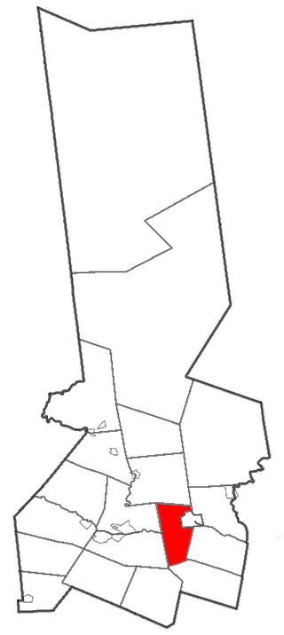
Danube is a town in Herkimer County, New York, United States. The population was 801 at the 2020 census, down from 1,039 in 2010. Early Palatine German immigrants in the eighteenth century named the town after the Danube River in Europe.

<span class="mw-page-title-main">German Flatts, New York</span> Town in Herkimer County, New York, US

German Flatts is a town in Herkimer County, New York, United States. The population was 12,263 at the 2020 census down from 13,258 at the 2010 census.

<span class="mw-page-title-main">Manheim, New York</span> Town in New York, United States

Manheim is a town in Herkimer County, New York, United States. The population was 3,334 at the 2010 census. The town name is derived from Mannheim in Baden, Germany.

<span class="mw-page-title-main">Middleville, New York</span> Village in New York, United States

Middleville is a village in Herkimer County, New York, United States. The population was 512 at the 2010 census.

Mohawk is a village in Herkimer County, New York, United States. The population was 2,731 at the 2010 census. The village was named after the adjacent Mohawk River.

<span class="mw-page-title-main">Norway, New York</span> Town in New York, United States

Norway is a town in Herkimer County, New York, United States. The population was 762 at the 2010 census. The town is located in the central part of the county and is northeast of Utica.

<span class="mw-page-title-main">Ohio, New York</span> Town in New York, United States

Ohio is a town in Herkimer County, New York, United States. The population was 1,002 at the 2010 census. The town is named after the state of Ohio. The town is in the northern part of the county and northeast of Utica. Part of Ohio is within the Adirondack Park.

Poland is a village in Herkimer County, New York, United States. The population was 508 at the 2010 census.

<span class="mw-page-title-main">Schuyler, New York</span> Town in Herkimer County, New York, US

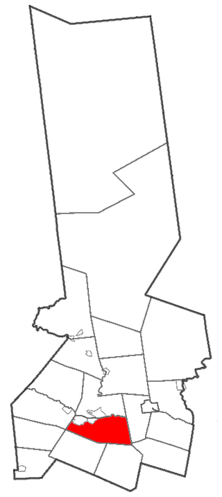
Schuyler is a town in Herkimer County, New York, United States. The population was 3,420 at the 2010 census. The town is in the western part of Herkimer County and is east of Utica.

<span class="mw-page-title-main">Stark, New York</span> Town in New York, United States

Stark is a town in Herkimer County, New York, United States. The population was 757 at the 2010 census. The town was named after Revolutionary War general John Stark.

<span class="mw-page-title-main">Winfield (town), New York</span> Town in New York, United States

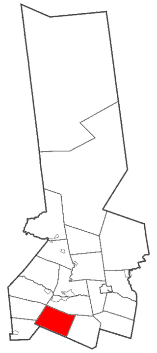
Winfield is a town in Herkimer County, New York, United States. The population was 2,086 at the 2010 census. The town is named after General Winfield Scott and is in the southwestern corner of the county, south of Utica.

<span class="mw-page-title-main">Whitestown, New York</span> Town in New York, United States

Whitestown is a town in Oneida County, New York, United States. The population was 18,667 at the 2010 census. The name is derived from Judge Hugh White, an early settler. The town is immediately west of Utica and the New York State Thruway passes across the town. The offices of the town of Whitestown are in the Village of Whitesboro.

<span class="mw-page-title-main">Frankfort, New York</span> Town in New York, United States

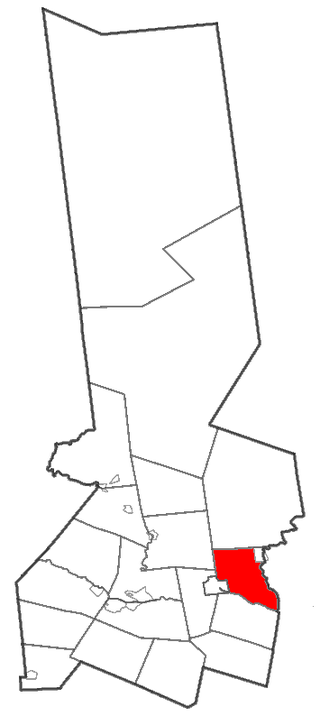
Frankfort is a town in Herkimer County, New York, United States. The town is named after one of its earliest settlers, Lawrence (Lewis) Frank. The town of Frankfort includes a village, also called Frankfort. Frankfort is located east of Utica, and the Erie Canal passes along its northern border. At the time of the 2020 census, the population was 7,011, down from 7,636 in 2010.

<span class="mw-page-title-main">Herkimer, New York</span> Town in New York, United States

Herkimer is a town in Herkimer County, New York, United States, southeast of Utica. It is named after Nicholas Herkimer. The population was 9,566 at the 2020 census, down from 10,175 in 2010.

<span class="mw-page-title-main">Little Falls (town), New York</span> Town in New York, United States

Little Falls is a town in Herkimer County, New York, United States. The population was 1,587 at the 2010 census. The town is named after falls and rapids on the Mohawk River nearby.

Newport is a village in Herkimer County, New York, United States. The population was 640 at the 2010 census.

<span class="mw-page-title-main">Newport, New York</span> Town in New York, United States

Newport is a town in Herkimer County, New York, United States. The population was 2,302 at the 2010 census. The town, located on the western edge of the county, contains the village of Newport. The town is northeast of Utica.

References

  1. https://www.townofdeerfield.org/government/board-and-committees/town-board/
  2. "2016 U.S. Gazetteer Files". United States Census Bureau. Retrieved July 5, 2017.
  3. 1 2 "Population and Housing Unit Estimates" . Retrieved June 9, 2017.
  4. "Census of Population and Housing". Census.gov. Retrieved June 4, 2015.
  5. "U.S. Census website". United States Census Bureau . Retrieved January 31, 2008.
  6. Who Was Who in America, Historical Volume, 1607-1896. Chicago: Marquis Who's Who. 1963.
  7. Edited by Natasha Sumner and Aidan Doyle (2020), North American Gaels: Speech, Song, and Story in the Diaspora, McGill-Queen's University Press. Pages 108-136.