Dereli

Last updated
Dereli
Town
Dereli Stream Giresun Turkey.jpg
Dereli stream
Turkey adm location map.svg
Red pog.svg
Dereli
Coordinates: 40°44′N38°26′E / 40.733°N 38.433°E / 40.733; 38.433 Coordinates: 40°44′N38°26′E / 40.733°N 38.433°E / 40.733; 38.433
Country Flag of Turkey.svg  Turkey
Region Black Sea
Province Giresun
Government
   Mayor Kazım Zeki Şenlikoğlu (AKP)
Area
[1]
  District845.24 km2 (326.35 sq mi)
Elevation
346 m (1,135 ft)
Population
(2012) [2]
   Urban
5,871
  District
20,875
  District density25/km2 (64/sq mi)
Time zone UTC+2 (EET)
  Summer (DST) UTC+3 (EEST)
Postal code
28950
Area code(s) 0454
Licence plate 28
Climate Cfb

Dereli is a town and district of Giresun Province in the Black Sea region of Turkey. The mayor is Kazım Zeki Şenlikoğlu (AKP).

Giresun Province Province of Turkey in East Black Sea

Giresun Province is a province of Turkey on the Black Sea coast. Its adjacent provinces are Trabzon to the east, Gümüşhane to the southeast, Erzincan to the south, Sivas to the southwest, and Ordu to the west. The provincial capital is Giresun.

Black Sea Region Region of Turkey

The Black Sea Region is a geographical region of Turkey.

Turkey Republic in Western Asia

Turkey, officially the Republic of Turkey, is a transcontinental country located mainly in Western Asia, with a smaller portion on the Balkan Peninsula in Southeast Europe. East Thrace, located in Europe, is separated from Anatolia by the Sea of Marmara, the Bosphorous strait and the Dardanelles. Turkey is bordered by Greece and Bulgaria to its northwest; Georgia to its northeast; Armenia, the Azerbaijani exclave of Nakhchivan and Iran to the east; and Iraq and Syria to the south. Ankara is its capital but Istanbul is the country's largest city. Approximately 70 to 80 per cent of the country's citizens identify as Turkish. Kurds are the largest minority; the size of the Kurdish population is a subject of dispute with estimates placing the figure at anywhere from 12 to 25 per cent of the population.

Contents

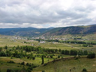
Dereli is a small town of 6,043 people in attractive countryside, in the valley of the Aksu Deresi and Akkaya River, inland 28 from Giresun on the road to Şebinkarahisar.

Aksu Deresi watercourse in Turkey

Aksu is one of the main water streams of Giresun Province in the eastern Black Sea Region of Turkey. Its name is Turkish for "white water".

Şebinkarahisar Place in Giresun, Turkey

Şebinkarahisar is a town in and the administrative seat for Şebinkarahisar District, Giresun Province in the Black Sea region of northeastern Turkey.

History

See Giresun for the history of this area, once occupied by the Hittites, Persians, Ancient Greek colonists from Miletos, Macedonians, Ancient Romans, Byzantines, Seljuk Turks, who settled in these valleys and arounds Muslim Kızılbaş, Turkmen Turks (Chepni) and finally the Ottoman Empire.

Hittites ancient Anatolian people who established an empire

The Hittites were an Anatolian people who played an important role in establishing an empire centered on Hattusa in north-central Anatolia around 1600 BC. This empire reached its height during the mid-14th century BC under Suppiluliuma I, when it encompassed an area that included most of Anatolia as well as parts of the northern Levant and Upper Mesopotamia.

Ancient Greek Version of the Greek language used from roughly the 9th century BCE to the 6th century CE

The Ancient Greek language includes the forms of Greek used in Ancient Greece and the ancient world from around the 9th century BCE to the 6th century CE. It is often roughly divided into the Archaic period, Classical period, and Hellenistic period. It is antedated in the second millennium BCE by Mycenaean Greek and succeeded by medieval Greek.

Ancient Macedonians Ancient ethnic group from the northeastern part of mainland Greece

The Macedonians were an ancient tribe that lived on the alluvial plain around the rivers Haliacmon and lower Axios in the northeastern part of mainland Greece. Essentially an ancient Greek people, they gradually expanded from their homeland along the Haliacmon valley on the northern edge of the Greek world, absorbing or driving out neighbouring non-Greek tribes, primarily Thracian and Illyrian. They spoke Ancient Macedonian, a language closely related to Ancient Greek, perhaps a dialect, although the prestige language of the region was at first Attic and then Koine Greek. Their religious beliefs mirrored those of other Greeks, following the main deities of the Greek pantheon, although the Macedonians continued Archaic burial practices that had ceased in other parts of Greece after the 6th century BC. Aside from the monarchy, the core of Macedonian society was its nobility. Similar to the aristocracy of neighboring Thessaly, their wealth was largely built on herding horses and cattle.

Places to see

Related Research Articles

Alucra District in Black Sea, Turkey

Alucra is a town and a district of Giresun Province in the Black Sea region of Turkey, 130 km (81 mi) from the city of Giresun. It was a district of Şebinkarahisar province between 1924-1933.

Bulancak District in Black Sea, Turkey

Bulancak is a town and a district of Giresun Province on the Black Sea coast of Turkey, near to the city of Giresun.

Çamoluk District in Black Sea, Turkey

Çamoluk is a town and a district of Giresun Province in the Black Sea region of Turkey.

Çanakçı Town in Black Sea, Turkey

Çanakçı is a town and a district of Giresun Province in the Black Sea region of Turkey.

Doğankent Place in Giresun, Turkey

Doğankent is a town and a district of Giresun Province in the Black Sea region of Turkey.

Espiye Town in Black Sea, Turkey

Espiye is a town and a district of Giresun Province in the Black Sea region of Turkey.

Eynesil Town in Black Sea, Turkey

Eynesil is a town and a district of Giresun Province on the Black Sea coast of Turkey, east of the city of Giresun, towards Trabzon. The population was 7,505 in 2010.

Güce Town in Black Sea, Turkey

Güce is a town and a district of Giresun Province in the Black Sea region of Turkey.

Keşap Town in Black Sea, Turkey

Keşap is a town and a district of Giresun Province on the Black Sea coast of Turkey just to the east of the city of Giresun.

Piraziz Town in Black Sea, Turkey

Piraziz is a town and a district of Giresun Province on the Black Sea coast of Turkey.

Tirebolu Place in Giresun, Turkey

Tirebolu is a town and district of Giresun Province, Turkey.

Çine Place in Aydın, Turkey

Çine is a town and a district of Aydın Province, in the Aegean region of Turkey, 38 km (24 mi) from the city of Aydın, on the road to Muğla.

Güdül District in Central Anatolia, Turkey

Güdül is a rural town and district of Ankara Province in the Central Anatolia region of Turkey, 90 km north-west of the city of Ankara, off the motorway to Istanbul. The district covers an area of 419 km², and the average elevation is 720 m. According to 2010 census, population of the district is 8971 of which 2623 live in the town of Güdül with the majority in the surrounding countryside.

Osmancık Town in Black Sea, Turkey

Osmancık is a district of Çorum Province in the Black Sea region of Turkey, located 59 km north of the city of Çorum.

Sultanhisar Place in Aydın, Turkey

Sultanhisar is a town and a small district of Aydın Province in the Aegean region of Turkey, 30 km east of the city of Aydın on the road to Denizli.

Dernekpazarı Place in Trabzon, Turkey

Dernekpazarı is a district of Trabzon Province in the Black Sea region of Turkey.The old name of the town was Kondu(or Kondualtı) and the current mayor of the town is Mehmet Aşık (AKP). Dernekpazarı is part of the Of-valley system ; it lies between the coastal Of district and the alpine Çaykara district.

Beypazarı, Ankara District in Central Anatolia, Turkey

Beypazarı is a Turkish town and district of Ankara Province in the Central Anatolia region of Turkey, approximately 100 km west of the city of Ankara. According to the 2000 census, the population of the district is 46,493, of which 35,775 live in the town of Beypazarı. The district covers an area of 1,814 km2 (700 sq mi), and the average elevation in the center is 675 m (2,215 ft). The district contains three other small towns and 64 villages. It used to be an important city in Asia Minor in ancient times.

Yavuzkemal Town in Giresun Province, Turkey

Yavuzkemal is a belde (town) in Dereli district of Giresun Province, Turkey. It is a dispersed settlement, typical of Black Sea region, situated at 40°38′N38°19′E to the west of Aksu River. The distance to Dereli is 20 kilometres (12 mi) and to Giresun is 64 kilometres (40 mi). The population of Yavuzkemal is 1669 as of 2011. The settlement was founded by a Turkmen tribe named Kırık in the 14th century and the former name of the settlement was Nahiye'i Kırık. According to official records of the Ottoman Empire the population of the settlement decreased in 1485 probably because some of the population was transferred to the newly conquered Trabzon. The settlement was declared a seat of township in 1998.

Karabörk Town in Giresun Province, Turkey

Karabörk is a belde (town) in Çanakçı district of Giresun Province, Turkey. The town is situated in the valley of Çanakçı creek at 40°53′N39°02′E. The town is in the middle of dense forestry of the Black Sea Region. The distance to Çanakçı is 17 kilometres (11 mi) and to Giresun is 85 kilometres (53 mi). The population of Karabörk was 1031. as of 2013. In Karabörk the Ottoman rule began by 1461 during the reign of Mehmet II. According to 1515 Ottoman records, it was a small settlement population of which was composed of Turks and Greeks. In the early 1700s, Turks of Çepni tribe also settled in the settlement. Ottomans mined copper in the Kırtlak mine close to Karabörk. In the early 20th century, Greek population left the settlement and during the First World War, the town suffered a brief occupation of the Russian army. In 1992 the settlement was declared a seat of township.

References

  1. "Area of regions (including lakes), km²". Regional Statistics Database. Turkish Statistical Institute. 2002. Retrieved 2013-03-05.
  2. "Population of province/district centers and towns/villages by districts - 2012". Address Based Population Registration System (ABPRS) Database. Turkish Statistical Institute. Retrieved 2013-02-27.

District

Dereli District Dereli.svg
Dereli District