Dorr Township, Illinois

Last updated

Dorr Township
Township
Flag of Dorr Township, McHenry County, Illinois.png
Logo of Dorr Township, McHenry County, Illinois.png
Map highlighting Dorr Township, McHenry County, Illinois.svg
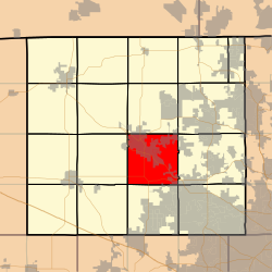
Location in McHenry County
Country United States
State Illinois
County McHenry
EstablishedNovember 6, 1849
Area
  Total
36 sq mi (90 km2)
  Land35.98 sq mi (93.2 km2)
  Water0.01 sq mi (0.03 km2)  0.03%
Population
 (2020)
  Total
21,752
  Density581.2/sq mi (224.4/km2)
Time zone UTC-6 (CST)
  Summer (DST) UTC-5 (CDT)
FIPS code 17-111-20396
Website Dorr Township Official Web Site

Dorr Township is located in McHenry County, Illinois. As of the 2020 census, its population was 21,752 and it contained 8,929 housing units. Dorr Township changed its name from Centre Township on December 28, 1850. It includes the census-designated place of Ridgefield.

Contents

History

Dorr Township is named after Governor Thomas Wilson Dorr of Rhode Island. [1] Governor Dorr helped to modernize voting in America by removing arcane age limitations and fighting for universal white male suffrage. Dorr was arrested and tried for treason before the Rhode Island Supreme Court. In 1844 he was committed to prison with a life sentence of solitary confinement and hard labor. He was released after 12 months but his health never fully recovered.

Geography

According to the 2010 census, the township has a total area of 36 square miles (93 km2), of which 35.98 square miles (93.2 km2) (or 99.94%) is land and 0.01 square miles (0.026 km2) (or 0.03%) is water. [2]

Dorr Township is one of seventeen townships in McHenry County. It covers portions of Woodstock, Crystal Lake, Lakewood and Bull Valley. Dorr Township covers 34 1/2 miles of road.

Demographics

Historical population
CensusPop.Note
2010 20,911
2020 21,5723.2%
U.S. Decennial Census [3]

References

  1. Callary, Edward (September 29, 2008). Place Names of Illinois. University of Illinois Press. p. 96. ISBN   978-0-252-09070-7.
  2. "Population, Housing Units, Area, and Density: 2010 - County -- County Subdivision and Place -- 2010 Census Summary File 1". United States Census. Archived from the original on February 12, 2020. Retrieved May 28, 2013.
  3. "Census of Population and Housing". Census.gov. Retrieved June 4, 2016.

42°17′07″N88°25′00″W / 42.28528°N 88.41667°W / 42.28528; -88.41667