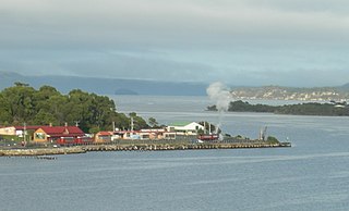
Strahan, is a small town and former port on the west coast of Tasmania. It is now a significant locality for tourism in the region.

Macquarie Harbour is a shallow fjord in the West Coast region of Tasmania, Australia. It is approximately 315 square kilometres (122 sq mi), and has an average depth of 15 metres (49 ft), with deeper places up to 50 metres (160 ft). It is navigable by shallow-draft vessels. The main channel is kept clear by the presence of a rock wall on the outside of the channel's curve. This man-made wall prevents erosion and keeps the channel deep and narrow, rather than allowing the channel to become wide and shallow. A reported Aboriginal name for the harbour is Parralaongatek.

West Coast Council is a local government body in Tasmania, covering much of the western region of the state. West Coast is classified as a rural local government area and has a population of 4,167. The major towns and localities of the region include Strahan, Rosebery, Zeehan and the principal town of Queenstown.

The Macquarie Harbour Penal Station, a former British colonial penal settlement, established on Sarah Island, Macquarie Harbour, in the former colony of Van Diemen's Land, now Tasmania, operated between 1822 and 1833. The settlement housed male convicts, with a small number of women housed on a nearby island. During its 11 years of operation, the penal colony achieved a reputation as one of the harshest penal settlements in the Australian colonies. The formal penal station is located on the eight-hectare (twenty-acre) Sarah Island that now operates as an historic site under the direction of the Tasmania Parks and Wildlife Service.

The West Coast Range is a mountain range located in the West Coast region of Tasmania, Australia.

The West Coast of Tasmania has a significant convict heritage. The use of the west coast as an outpost to house convicts in isolated penal settlements occurred in the eras 1822–33, and 1846–47.

The West Coast of Tasmania is mainly isolated rough country, associated with wilderness, mining and tourism. It served as the location of an early convict settlement in the early history of Van Diemen's Land, and contrasts sharply with the more developed and populous northern and eastern parts of the island state.

Regatta Point is the location of a port and rail terminus on Macquarie Harbour.
Trial Harbour is a rural locality in the local government area (LGA) of West Coast in the North-west and west LGA region of Tasmania. The locality is about 20 kilometres (12 mi) south-west of the town of Zeehan. The 2016 census has a population of 24 for the state suburb of Trial Harbour.
Mount Sorell is a mountain located in the West Coast region of Tasmania, Australia.

Cape Sorell is a headland located in the Southern Ocean outside Macquarie Harbour on the West Coast of Tasmania, Australia. The cape and the Cape Sorell Lighthouse, located above the headland, are important orientation points for all vessels entering the Macquarie Heads and then through Hells Gates at the entrance to the harbour.
Ocean Beach is a long stretch of beach running north of Macquarie Heads and Hells Gates on the West Coast of Tasmania. It is close to Strahan and parallel to the Strahan Airport runway. It extends as far north as Trial Harbour and the coast immediately west of Zeehan.

The Round Earth Company, founded by the late Richard Davey, performs in Strahan, West Coast, Tasmania. Each night the company performs Australia's longest-running play, The Ship That Never Was. During the day the actors work as tour guides on Sarah Island, explaining the history and unique story of this Tasmanian penal settlement.
The history of the Railways on the West Coast of Tasmania has fascinated enthusiasts from around the world, because of the combination of the harsh terrain in which the railways were created, and the unique nature of most of the lines.

William Sorell was a soldier and third Lieutenant-Governor of Van Diemen's Land.
Mount Strahan is a mountain located on the West Coast Range in the West Coast region of Tasmania, Australia. With an elevation of 855 metres (2,805 ft) above sea level, the mountain is situated directly east of Macquarie Harbour and, like Mount Sorell, dominates the east side of the harbour near Sarah Island.

Bonnet Island is a low island with an area of 2.21 ha. It lies at the entrance to Macquarie Harbour in Western Tasmania Australia, in the vicinity of Hells Gates. Due to its location and proximity to the entrance, it was involved as part the Macquarie Harbour Breakwater construction.
The Macquarie Heads Breakwater was a project of the Strahan Marine Board in Western Tasmania to sustain a reasonable depth to the Hells Gates and Macquarie Heads of the Macquarie Harbour area to allow for shipping of limited tonnage to serve Regatta Point while the Mount Lyell Mining and Railway Company was exporting its mineral products by sea. The heads were notoriously difficult to navigate in good weather, and even more difficult in bad weather.

The Birchs Inlet, also spelt Birch's Inlet or Birches Inlet, is a narrow cove or coastal inlet on the south-western side of Macquarie Harbour on the west coast of Tasmania, Australia. The inlet is located within the Southwest National Park, part of the Tasmanian Wilderness World Heritage Area.


