Hibiscus Coast | |
|---|---|
 Seal | |
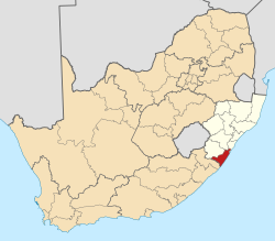
 Location of Hibiscus Coast Local Municipality within KwaZulu-Natal | |
| Coordinates: 30°45′S30°23′E / 30.750°S 30.383°E | |
| Country | South Africa |
| Province | KwaZulu-Natal |
| District | Ugu |
| Seat | Port Shepstone |
| Wards | 29 |
| Government | |
| • Type | Municipal council |
| • Mayor | Cynthia Mqwebu |
| Area | |
• Total | 839 km2 (324 sq mi) |
| Population (2011) [2] | |
• Total | 256,135 |
| • Density | 310/km2 (790/sq mi) |
| Racial makeup (2011) | |
| • Black African | 82.4% |
| • Coloured | 1.4% |
| • Indian/Asian | 5.1% |
| • White | 10.8% |
| First languages (2011) | |
| • Zulu | 70.7% |
| • English | 14.2% |
| • Xhosa | 7.7% |
| • Afrikaans | 4.5% |
| • Other | 2.9% |
| Time zone | UTC+2 (SAST) |
| Municipal code | KZN216 |
Hibiscus Coast Local Municipality was a local municipality in the province of KwaZulu-Natal in South Africa. It governed the Hibiscus Coast on the KwaZulu-Natal South Coast which attracts tourists from the province and other provinces as well as international tourists.
Contents
After municipal elections on 3 August 2016 it was merged into the larger Ray Nkonyeni Local Municipality.
Beaches are to be found along the entire seaboard. Hibberdene Beach, Ramsgate Beach, Marina Beach/San Lameer, and Lucien Beach have been recognized as Blue Flag beaches. [3] The climate of the coastal areas is humid and subtropical — comparable to southern Florida in the United States, but not quite as hot and rainy in the summer.
The coastline is dotted with small towns, many of which serve as seasonal recreational hubs, such as Port Shepstone, Umtamvuna / Port Edward, Margate, Hibberdene and Impenjati / Southbroom. These towns feature a wide range of tourist-oriented businesses, including restaurants, bars, clubs, movie houses, golf courses, clothing shops, museums, and various types of accommodations. The income from these businesses has economically benefited the municipality as a whole. [4]
Other economic activities include fishing, agriculture, crafts, and bead works.
The hilly inland regions of the municipality are largely under the ownership of tribal authorities. Such "traditional" settlements include KwaXolo, KwaNzimakwe, KwaNdwalane, KwaMadlala, KwaMavundla and KwaLushaba.