Highlands, New York

Last updated

Highlands
Town of Highlands
U.S. Military Academy - Valley.JPG
Orange County New York incorporated and unincorporated areas Highlands highlighted.svg
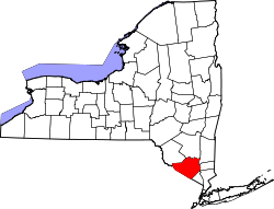
Location in Orange County and the state of New York.
USA New York location map.svg
Red pog.svg
Highlands
Location within the state of New York
Coordinates: 41°21′36″N074°00′30″W / 41.36000°N 74.00833°W / 41.36000; -74.00833   [1]
Country United States
State New York
County Orange
Government
 (as of 2013) [2]
  Type Town Council
   Town Supervisor Bob Livsey (D)
   Town Council
Members' List
Area
[3]
  Total33.46 sq mi (86.65 km2)
  Land30.40 sq mi (78.73 km2)
  Water3.06 sq mi (7.93 km2)  9.15%
Elevation
[1]
1,017 ft (310 m)
Population
 (2020) [4]
  Total12,939
  Density425.67/sq mi (164.35/km2)
Time zone UTC-5 (Eastern (EST))
  Summer (DST) UTC-4 (EDT)
FIPS code [5] [6] 36-34550
GNIS feature ID [5] [6] 979067
Website highlands-ny.gov

Highlands is a town on the eastern border of Orange County, New York. The population was 12,939 at the 2020 census. [4] West Point, including the United States Military Academy, is located alongside the Hudson River in Highlands, and the military reservation occupies a large part of the town.

Contents

History

The town was first settled circa 1725 by John Moore, a patentee for this territory. During the American Revolution, colonial forces constructed Fort Montgomery and Fort Clinton to obstruct enemy progress on the river. Highlands was created from the town of Cornwall in 1872, making it one of the last towns formed in the county.

Geography

Highlands is located at 41°21′36″N074°00′30″W / 41.36000°N 74.00833°W / 41.36000; -74.00833 (41.3601108, -74.0084276) and its elevation is 1,017 feet (310 m). [1] According to the 2020 U.S. census, the town has a total area of 33.46 square miles (86.66 km2), of which 30.40 square miles (78.74 km2) is land and 3.06 square miles (7.93 km2) is water. [3] Part of the southern town line is the border of Rockland County. The eastern town boundary is the border of Putnam County, marked by the Hudson River.

US-9W and NY-218 are important north-south highways. NY-293 intersects these, west of the military academy.

Demographics

Historical population
CensusPop.Note
1880 3,404
1890 4,09920.4%
1900 4,51910.2%
1910 6,13335.7%
1920 6,1360.0%
1930 7,05715.0%
1940 9,30731.9%
1950 10,46712.5%
1960 11,99014.6%
1970 14,66122.3%
1980 14,004−4.5%
1990 13,667−2.4%
2000 12,484−8.7%
2010 12,4920.1%
2020 12,9393.6%
U.S. Decennial Census [7]

As of the census [8] of 2000, there were 12,484 people, 3,230 households, and 2,322 families residing in the town. The population density was 404 inhabitants per square mile (156/km2). There were 3,418 housing units at an average density of 110.6 per square mile (42.7/km2). The racial makeup of the town was 75.18% White, 13.16% African American, .49% Native American, 2.68% Asian, 0.16% Pacific Islander, 2.27% from other races, and 3.08% from two or more races. Hispanic or Latino of any race were 9.71% of the population.

There were 3,230 households, out of which 43.8% had children under the age of 18 living with them, 59.6% were married couples living together, 8.9% had a female householder with no husband present, and 28.1% were non-families. 24.1% of all households were made up of individuals, and 8.5% had someone living alone who was 65 years of age or older. The average household size was 2.74 and the average family size was 3.32.

The age distribution is 22.8% under the age of 18, 32.1% from 18 to 24, 26.7% from 25 to 44, 12.2% from 45 to 64, and 6.2% who were 65 years of age or older. The median age was 23 years. For every 100 females, there were 147.7 males. For every 100 females age 18 and over, there were 162.2 males. These statistics are consistent with the presence of the West Point military base in general, and the Academy in particular.

The median income for a household in the town was $52,816, and the median income for a family was $59,345. Males had a median income of $23,491 versus $27,406 for females. The per capita income for the town was $17,830. About 2.8% of families and 3.6% of the population were below the poverty line, including 4.3% of those under age 18 and 3.0% of those age 65 or over.

Communities and locations in the Town of Highlands

Crow's Nest reflecting in the Hudson River Crow's Nest Mountain reflection in Hudson.JPG
Crow's Nest reflecting in the Hudson River

Government in Highlands

Highlands is represented in the Orange County legislature by Laurie Tautel (D).

Education

Most of Highlands is in Highland Falls-Fort Montgomery Central School District. A portion to the southwest is in the Haverstraw-Stony Point Central School District (North Rockland). [9] James I. O'Neill High School is the high school of the Highland Falls-Fort Montgomery portion while North Rockland High School is the high school for the North Rockland part.

The Department of Defense Education Activity (DoDEA) maintains elementary and middle schools for children of military personnel on-post at USMA, [10] but sends high school aged students who are dependents of on-base military personnel to O'Neill. [11] In March 2022 USMA's contract with O'Neill was renewed. [12]

There was also a parochial school in Highland Falls, Sacred Heart of Jesus School (of the Roman Catholic Archdiocese of New York), that served students in grades pre-kindergarten through eight. The school opened in 1930 and closed in 2011. [13] The archdiocese suggested that parents send their children to St. Gregory Barbarigo School in Garnerville. [14]

Related Research Articles

<span class="mw-page-title-main">Montgomery County, New York</span> County in New York, United States

Montgomery County is a county in the U.S. state of New York. As of the 2020 census, the population was 49,532. The county seat is Fonda. The county was named in honor of Richard Montgomery, an American Revolutionary War general killed in 1775 at the Battle of Quebec. The county is part of the Mohawk Valley region of the state.

<span class="mw-page-title-main">Orange County, New York</span> County in New York, United States

Orange County is a county located in the U.S. state of New York. As of the 2020 census, the population was 401,310. The county seat is Goshen. This county was first created in 1683 and reorganized with its present boundaries in 1798. The county is part of the Hudson Valley region of the state.

<span class="mw-page-title-main">Rockland County, New York</span> County in New York, United States

Rockland County is the second-southernmost county on the west side of the Hudson River in the U.S. state of New York, after Richmond County. It is part of the New York metropolitan area. As of the 2020 U.S. census, the county's population is 338,329, making it the state's third-most densely populated county outside New York City after Nassau and neighboring Westchester Counties. The county seat and largest hamlet is New City. Rockland County is accessible via the New York State Thruway, which crosses the Hudson to Westchester at the Tappan Zee Bridge ten exits up from the NYC border, as well as the Palisades Parkway five exits up from the George Washington Bridge. The county's name derives from "rocky land", as the area has been aptly described, largely due to the Hudson River Palisades. The county is part of the Hudson Valley region of the state.

<span class="mw-page-title-main">Highland City, Florida</span> Census-designated place in Florida, United States

Highland City is a census-designated place (CDP) in Polk County, Florida, United States. The population was 2,051 at the 2000 census. It is part of the Lakeland–Winter Haven Metropolitan Statistical Area.

Fort Johnson is a hamlet and former village in Montgomery County, New York, United States located on the north side of the Mohawk River in the town of Amsterdam. The population was 490 at the 2010 census.

<span class="mw-page-title-main">Fort Montgomery, New York</span> CDP in New York, United States

Fort Montgomery is a hamlet in Orange County, New York, United States. The population was 1,627 at the 2020 census. It is part of the Poughkeepsie–Newburgh–Middletown, NY Metropolitan Statistical Area as well as the larger New York–Newark–Bridgeport, NY-NJ-CT-PA Combined Statistical Area.

<span class="mw-page-title-main">Highland Falls, New York</span> Village in New York, United States

Highland Falls, formerly named Buttermilk Falls, is a village in Orange County, New York, United States. The population was 3,684 at the 2020 census. The village was founded in 1906. It is part of the Poughkeepsie–Newburgh–Middletown, NY Metropolitan Statistical Area as well as the larger New York–Newark–Bridgeport, NY-NJ-CT-PA Combined Statistical Area.

<span class="mw-page-title-main">West Point, New York</span> CDP in New York, United States

West Point is the oldest continuously occupied military post in the United States. Located on the Hudson River in New York, General George Washington stationed his headquarters in West Point in the summer and fall of 1779 during the American Revolutionary War, and later called it "the most important Post in America" in 1781 following the war's end. West Point also was the site of General Benedict Arnold's infamous and failed attempt at treason during the Revolutionary War.

<span class="mw-page-title-main">Philipstown, New York</span> Town in New York, United States

Philipstown is a town located in the western part of Putnam County, New York, United States. The population was 9,831 at the 2020 census.

<span class="mw-page-title-main">Clarkstown, New York</span> Town in New York, United States

Clarkstown is a town in Rockland County, New York, United States. The town is on the eastern border of the county, located north of the town of Orangetown, east of the town of Ramapo, south of the town of Haverstraw, and west of the Hudson River. As of the 2020 census, the town had a total population of 86,855. The hamlet of New City, the county seat of Rockland County, is also the seat of town government and of the Clarkstown Police Department, the county sheriff's office, and the county correctional facility. New City makes up about 41.47% of the town's population.

<span class="mw-page-title-main">New Hempstead, New York</span> Village in New York, United States

New Hempstead is a village in the town of Ramapo, Rockland County, New York, United States. It is located north of New Square, east of Wesley Hills, south of Pomona, and west of New City. The population was 5,132 at the 2010 census. Residents utilize the Spring Valley and New City post offices.

<span class="mw-page-title-main">Nyack, New York</span> Village in New York, United States

Nyack is a village located primarily in the town of Orangetown in Rockland County, New York, United States. Incorporated in 1872, it retains a very small western section in Clarkstown. The village had a population of 7,265 as of the 2020 census. It is a suburb of New York City lying approximately 15 miles (24 km) north of the Manhattan boundary near the west bank of the Hudson River, situated north of South Nyack, east of Central Nyack, south of Upper Nyack, and southeast of Valley Cottage.

<span class="mw-page-title-main">Orangetown, New York</span> Town in New York, United States

Orangetown is a town in Rockland County, New York, United States, located in the southeastern part of the county. It is northwest of New York City, north of New Jersey, east of the town of Ramapo, south of the town of Clarkstown, and west of the Hudson River. The population was 48,655 at the 2020 census.

<span class="mw-page-title-main">Thiells, New York</span> Census-designated place in New York, United States

Thiells, known as Thiell's Corner in the 1850s, is a hamlet and census-designated place (CDP) in the town of Haverstraw, Rockland County, New York, United States. It is located north of Mount Ivy, east of Pomona, south of Tomkins Cove, and west of Garnerville. The population was 5,240 as of the 2020 census.

<span class="mw-page-title-main">Lloyd, New York</span> Town in New York, United States

Lloyd is a town in Ulster County, New York, United States. The population was 11,133 at the 2020 census. It is part of the New York City combined statistical area.

<span class="mw-page-title-main">Haverstraw, New York</span> Town in New York, United States

Haverstraw is a town in Rockland County, New York, United States, located north of the Town of Clarkstown and the Town of Ramapo; east of Orange County; south of the Town of Stony Point; and west of the Hudson River. The town runs from the west to the east border of the county in its northern section. The population was 39,087 at the 2020 census.

<span class="mw-page-title-main">Stony Point, New York</span> Town in New York, United States

Stony Point is a town in Rockland County, New York, United States. It is part of the New York City Metropolitan Area. The town is located north of the town of Haverstraw, east and south of Orange County, and west of the Hudson River and Westchester County. The population was 14,813 at the 2020 census. The name of the town is derived from a prominent projection into the Hudson River.

<span class="mw-page-title-main">Kiryas Joel-Poughkeepsie-Newburgh metropolitan area</span> Metropolitan statistical area in New York, United States

The Kiryas Joel-Poughkeepsie-Newburgh, NY Metropolitan Statistical Area, as defined by the United States Office of Management and Budget, is an area consisting of two counties in New York's Hudson Valley, with the municipalities of Kiryas Joel, Poughkeepsie, and Newburgh as its principal cities. As of the 2020 census, the MSA had a population of 679,221. The area was centered on the urban area of Poughkeepsie-Newburgh. Prior to July 2023, it was known as the Poughkeepsie-Newburgh-Middletown, NY Metropolitan Statistical Area; whereupon it was renamed to its current name, to reflect population changes among its largest municipalities.

<span class="mw-page-title-main">Fort Edward (village), New York</span> Village in New York, United States

Fort Edward is a village in Washington County, New York, United States. It is part of the Glens Falls Metropolitan Statistical Area. The village population was 3,375 at the 2010 census. The name is derived from the younger brother of King George III, Edward Augustus, Duke of York and Albany.

Highland Falls-Fort Montgomery Central School District (HFFMCSD) is a school district headquartered in Highland Falls, New York.

References

  1. 1 2 3 "Town of Highlands". Geographic Names Information System . United States Geological Survey, United States Department of the Interior . Retrieved June 18, 2013.
  2. "Supervisor and Town Board members". Town of Highlands. Retrieved June 18, 2013.
  3. 1 2 "2020 U.S. Gazetteer Files". United States Census Bureau. Retrieved March 7, 2024.
  4. 1 2 "QuickFacts: Highlands town, Orange County, New York". United States Census Bureau . Retrieved March 7, 2024.
  5. 1 2 "County Subdivisions: New York". 2010 Census Gazetteer Files . United States Census Bureau. Archived from the original (TXT) on May 17, 2014. Retrieved January 15, 2013.{{cite web}}: External link in |work= (help)
  6. 1 2 "FIPS55 Data: New York". FIPS55 Data . United States Geological Survey. February 23, 2006. Archived from the original (TXT) on October 19, 2006.{{cite web}}: External link in |work= (help)
  7. "Census of Population and Housing". Census.gov. Retrieved June 4, 2015.
  8. "U.S. Census website". United States Census Bureau . Retrieved January 31, 2008.
  9. "2020 CENSUS - SCHOOL DISTRICT REFERENCE MAP: Orange County, NY" (PDF). U.S. Census Bureau . Retrieved July 4, 2022.
  10. "West Point Community". Department of Defense Education Activity . Retrieved July 4, 2022. - Elementary site and Middle site
  11. Wang, Helu (September 27, 2021). "Could Highland Falls lose its West Point students?". Times Herald-Record . Retrieved July 5, 2022.
  12. Randall, Mike (March 21, 2022). "Highland Falls' contract to educate West Point high school students is renewed". Times Herald-Record . Retrieved July 5, 2022.
  13. Randall, Michael (January 21, 2011). "Sacred Heart school's supporters down to the last Hail Mary". Times Herald Record . Retrieved July 6, 2022.
  14. Randall, Michael (January 14, 2011). "Parents bid to save Sacred Heart of Jesus School in Highland Falls". Times Herald Record . Retrieved July 6, 2022.