Hobbs Peak (Wyoming)

Last updated
Hobbs Peak
Hobbs Peak.jpg
East aspect of Hobbs Peak
(Hobbs Park in foreground)
Highest point
Elevation 11,663 ft (3,555 m) [1]
Prominence 403 ft (123 m) [1]
Parent peak Lizard Head Peak (12,847 ft) [2]
Isolation 0.85 mi (1.37 km) [1]
Coordinates 42°51′54″N109°07′29″W / 42.8651315°N 109.1246493°W / 42.8651315; -109.1246493 [3]
Geography
USA Wyoming relief location map.svg
Red triangle with thick white border.svg
Hobbs Peak
Location in Wyoming
Usa edcp relief location map.png
Red triangle with thick white border.svg
Hobbs Peak
Hobbs Peak (the United States)
CountryUnited States
State Wyoming
County Fremont
Protected area Popo Agie Wilderness
Parent range Rocky Mountains
Wind River Range
Topo map USGS Dickinson Park
Geology
Type of rock granitic
Climbing
Easiest route class 3 scrambling [1]

Hobbs Peak is an 11,663-foot-elevation (3,555-meter) mountain summit in Fremont County, Wyoming, United States. [3]

Contents

Description

Hobbs Peak is located in the remote Wind River Range which is a subrange of the Rocky Mountains. [2] It is set nine miles (14 km) east of the Continental Divide within the Popo Agie Wilderness, on land managed by Shoshone National Forest. Hobbs Peak ranks as the 40th-highest peak in the wilderness and is two miles (3.2 km) west of Hobbs Park. [1] The nearest town is Lander, 18 miles (29 km) to the southeast. Precipitation runoff from the mountain drains into tributaries of the Wind River. Topographic relief is significant as the summit rises over 1,800 feet (550 meters) above Sand Lake in 0.85 mile (1.37 km). The mountain's toponym has been officially adopted by the United States Board on Geographic Names. [3]

Climate

According to the Köppen climate classification system, Hobbs Peak has an alpine subarctic climate with long, cold, snowy winters, and cool to warm summers. [4] Due to its altitude, it receives precipitation all year, as snow in winter and as thunderstorms in summer.

Climate data for Hobbs Peak (WY) 42.8653 N, 109.1249 W, Elevation: 11,158 ft (3,401 m) (1991–2020 normals)
MonthJanFebMarAprMayJunJulAugSepOctNovDecYear
Average high °F (°C)23.8
(−4.6)
23.7
(−4.6)
29.7
(−1.3)
35.3
(1.8)
43.8
(6.6)
54.2
(12.3)
63.7
(17.6)
62.2
(16.8)
53.3
(11.8)
41.0
(5.0)
29.3
(−1.5)
22.8
(−5.1)
40.2
(4.6)
Daily mean °F (°C)14.1
(−9.9)
13.2
(−10.4)
18.4
(−7.6)
23.5
(−4.7)
32.1
(0.1)
41.8
(5.4)
50.1
(10.1)
49.3
(9.6)
41.1
(5.1)
29.9
(−1.2)
19.7
(−6.8)
13.4
(−10.3)
28.9
(−1.7)
Average low °F (°C)4.3
(−15.4)
2.7
(−16.3)
7.2
(−13.8)
11.7
(−11.3)
20.5
(−6.4)
29.4
(−1.4)
36.4
(2.4)
36.4
(2.4)
28.8
(−1.8)
18.8
(−7.3)
10.1
(−12.2)
3.9
(−15.6)
17.5
(−8.1)
Average precipitation inches (mm)1.86
(47)
2.04
(52)
2.81
(71)
4.57
(116)
5.08
(129)
2.60
(66)
1.30
(33)
1.19
(30)
2.00
(51)
2.52
(64)
2.02
(51)
1.99
(51)
29.98
(761)
Source: PRISM Climate Group [5]

Hobbs Park is an elevated plain at the foot of Hobbs Peak. Hobbs Park also has a subarctic climate (Köppen Dfc) but is slightly warmer due to its lower elevation.

Climate data for Hobbs Park, Wyoming, 1991–2020 normals: 10100ft (3078m)
MonthJanFebMarAprMayJunJulAugSepOctNovDecYear
Average high °F (°C)29.7
(−1.3)
30.2
(−1.0)
36.7
(2.6)
42.0
(5.6)
49.7
(9.8)
58.6
(14.8)
67.3
(19.6)
65.6
(18.7)
56.6
(13.7)
45.0
(7.2)
34.6
(1.4)
27.9
(−2.3)
45.3
(7.4)
Daily mean °F (°C)18.8
(−7.3)
18.6
(−7.4)
24.4
(−4.2)
29.5
(−1.4)
38.1
(3.4)
46.5
(8.1)
54.3
(12.4)
52.9
(11.6)
44.9
(7.2)
34.3
(1.3)
24.2
(−4.3)
17.7
(−7.9)
33.7
(1.0)
Average low °F (°C)7.9
(−13.4)
6.9
(−13.9)
12.1
(−11.1)
17.1
(−8.3)
26.6
(−3.0)
34.5
(1.4)
41.3
(5.2)
40.2
(4.6)
33.2
(0.7)
23.4
(−4.8)
13.8
(−10.1)
7.4
(−13.7)
22.0
(−5.5)
Average precipitation inches (mm)1.58
(40)
1.91
(49)
2.99
(76)
4.19
(106)
4.50
(114)
2.27
(58)
1.15
(29)
1.14
(29)
1.92
(49)
2.42
(61)
1.83
(46)
1.84
(47)
27.74
(704)
Source 1: XMACIS2 [6]
Source 2: NOAA (Precipitation) [7]

Hazards

Encountering bears is a concern in the Wind River Range. [8] There are other concerns as well, including bugs, wildfires, adverse snow conditions and nighttime cold temperatures. [9]

Importantly, there have been notable incidents, including accidental deaths, due to falls from steep cliffs (a misstep could be fatal in this class 4/5 terrain) and due to falling rocks, over the years, including 1993, [10] 2007 (involving an experienced NOLS leader), [11] 2015 [12] and 2018. [13] Other incidents include a seriously injured backpacker being airlifted near Squaretop Mountain [14] in 2005, [15] and a fatal hiker incident (from an apparent accidental fall) in 2006 that involved state search and rescue. [16]

See also

Related Research Articles

<span class="mw-page-title-main">Gannett Peak</span> Mountain in Wyoming, United States

Gannett Peak is the highest mountain peak in the U.S. state of Wyoming at 13,810 feet (4,210 m). It lies in the Wind River Range within the Bridger Wilderness of the Bridger-Teton National Forest. Straddling the Continental Divide along the boundary between Fremont and Sublette counties, it has the second greatest topographic prominence in the state (7076') after Cloud Peak (7077'), and is the highest ground for 290.36 miles in any direction.

<span class="mw-page-title-main">Fremont Peak (Wyoming)</span> Mountain in the state of Wyoming

Fremont Peak is the third highest peak in the state of Wyoming, surpassed only by Gannett Peak and Grand Teton, and straddles the boundary between Fremont and Sublette counties in the Wind River Range. It is named for American explorer John C. Frémont who climbed the peak with Charles Preuss and Johnny Janisse from August 13 to August 15, 1842. Kit Carson had been with the climbing party on its first attempt at the peak, but had gone back for supplies the day Fremont and his men reached the summit. Carson is thought by some to have been the first to climb neighboring Jackson Peak. At that time, Fremont Peak was mistakenly thought to be the highest mountain in the Rocky Mountains, although there are actually over 100 higher peaks in the Rocky Mountain range.

<span class="mw-page-title-main">Wind River Peak</span> Mountain in Wyoming, United States

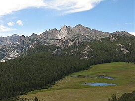
Wind River Peak is the highest point in the southern end of the Wind River Range that is located in the U.S. state of Wyoming. The peak straddles the Continental Divide and is surrounded by National Forest lands. The west slopes are in the Bridger Wilderness of Bridger-Teton National Forest, while the east side is in the Popo Agie Wilderness of Shoshone National Forest. In a cirque on the northeast slopes of the peak lies Wind River Glacier.

Mount Febbas is located in the Wind River Range in the U.S. state of Wyoming. Mount Febbas is at the western end of the high-altitude plateau known as Horse Ridge, which extends for more than 10 mi (16 km) to the northeast at elevations greater than 10,000 ft (3,000 m).

<span class="mw-page-title-main">Flagstone Peak (Fremont County, Wyoming)</span>

Flagstone Peak is located in the Wind River Range in the U.S. state of Wyoming. The peak is the 12th highest peak in Wyoming. The summit is located on the Continental Divide and is in both Shoshone and Bridger-Teton National Forests. The Flagstone Peak-Southeast Peak lies .25 mi (0.40 km) to the southeast.

Downs Mountain is located in the Wind River Range in the U.S. state of Wyoming. Downs Mountain is the 15th highest peak in Wyoming. The summit is on the Continental Divide in both Shoshone and Bridger-Teton National Forests. The East Torrey Glacier is on the northern slopes of Downs Mountain, while Continental Glacier lies to the west and north and the Downs Glacier is 1 mi (1.6 km) to the south.

Shale Mountain is located in the northern Wind River Range in the U.S. state of Wyoming. Shale Mountain straddles the Continental Divide and is in both Bridger-Teton and Shoshone National Forests. Shale Mountain is 5 mi (8.0 km) north of Downs Mountain.

<span class="mw-page-title-main">Torrey Peak (Wyoming)</span> Mountain in the American state of Wyoming

Torrey Peak is located in the northern Wind River Range in the U.S. state of Wyoming. Torrey Peak is in Shoshone National Forest near the southern end of Upper Ross Lake.

Brown Cliffs North is located in the northern Wind River Range in the U.S. state of Wyoming. Brown Cliffs North is the 18th tallest peak in Wyoming. The summit is at the northwestern end of a ridge known as Brown Cliffs which are in the Fitzpatrick Wilderness of Shoshone National Forest.

<span class="mw-page-title-main">Twin Peaks (Wyoming)</span>

Twin Peaks is located in the Wind River Range in the U.S. state of Wyoming. Twin Peaks is the 20th highest peak in Wyoming. Twin Peaks is in the Bridger Wilderness of Bridger-Teton National Forest and is .58 mi (0.93 km) southwest of Mount Woodrow Wilson and about the same distance southeast of Split Mountain. Mammoth Glacier flows from the north slopes of the peak while the smaller Twins Glacier flows to the southeast.

<span class="mw-page-title-main">Atlantic Peak</span>

Atlantic Peak is located in the southern Wind River Range in the U.S. state of Wyoming. Atlantic Peak sits along the Continental Divide, less than 1 mi (1.6 km) southeast of West Atlantic Peak.

Big Sandy Mountain is located in the southern Wind River Range in the U.S. state of Wyoming. Big Sandy Mountain sits along the Continental Divide, less than 1 mi (1.6 km) southeast of Dog Tooth Peak.

<span class="mw-page-title-main">Squaretop Mountain</span> Mountain in the American state of Wyoming

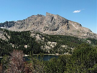
Squaretop Mountain is an 11,695-foot-elevation (3,565-meter) mountain summit located in Sublette County of Wyoming, United States.

<span class="mw-page-title-main">White Rock (Wyoming)</span> Cliff in the American state of Wyoming

White Rock is a cliff with an 11,284-foot-elevation (3,439-meter) summit located in Sublette County of Wyoming, United States.

<span class="mw-page-title-main">Haystack Mountain (Wyoming)</span> Mountain peak in Wyoming, US

Haystack Mountain is an 11,978-foot-elevation (3,651-meter) mountain summit located in Sublette County of Wyoming, United States.

<span class="mw-page-title-main">Schiestler Peak</span> Mountain in the country of Canada

Schiestler Peak is an 11,624-foot-elevation (3,543-meter) mountain summit located in Sublette County of Wyoming, United States.

<span class="mw-page-title-main">Steeple Peak</span> Mountain in the country of Canada

Steeple Peak is a 12,040-foot-elevation (3,670-meter) summit located in Sublette County of Wyoming, United States.

<span class="mw-page-title-main">Mount Lester</span> Mountain of Sublette County, Wyoming

Mount Lester is a 12,342-foot-elevation (3,762-meter) mountain summit located in Sublette County, Wyoming, United States.

<span class="mw-page-title-main">Mount Geikie (Wyoming)</span>

Mount Geikie is a 12,378-foot-elevation (3,773-meter) mountain summit in Sublette County, Wyoming, United States.

<span class="mw-page-title-main">Ladd Peak</span>

Ladd Peak is a 12,967-foot-elevation (3,952-meter) mountain summit in Sublette County, Wyoming, United States.

References

  1. 1 2 3 4 5 "Hobbs Peak - 11,663' WY". listsofjohn.com. Retrieved 2023-07-21.
  2. 1 2 "Hobbs Peak, Peakvisor.com" . Retrieved 2023-07-21.
  3. 1 2 3 "Hobbs Peak". Geographic Names Information System . United States Geological Survey, United States Department of the Interior . Retrieved 2023-07-21.
  4. Peel, M. C.; Finlayson, B. L.; McMahon, T. A. (2007). "Updated world map of the Köppen−Geiger climate classification". Hydrol. Earth Syst. Sci. 11. ISSN   1027-5606.
  5. "PRISM Climate Group, Oregon State University". PRISM Climate Group, Oregon State University. Retrieved October 12, 2023. To find the table data on the PRISM website, start by clicking Coordinates (under Location); copy Latitude and Longitude figures from top of table; click Zoom to location; click Precipitation, Minimum temp, Mean temp, Maximum temp; click 30-year normals, 1991-2020; click 800m; click Retrieve Time Series button.
  6. "xmACIS2". National Oceanic and Atmospheric Administration. Retrieved October 12, 2023.
  7. "Hobbs Park, Wyoming 1991-2020 Monthly Normals" . Retrieved October 12, 2023.
  8. Staff (April 24, 2017). "Bear Safety in Wyoming's Wind River Country". WindRiver.org . Retrieved February 17, 2019.
  9. Ballou, Dawn (July 27, 2005). "Wind River Range condition update - Fires, trails, bears, Continental Divide". PineDaleOnline News. Retrieved February 17, 2019.
  10. Staff (1993). "Falling Rock, Loose Rock, Failure to Test Holds, Wyoming, Wind River Range, Seneca Lake". American Alpine Club . Retrieved February 15, 2019.
  11. MacDonald, Dougald (August 14, 2007). "Trundled Rock Kills NOLS Leader". Climbing . Retrieved February 15, 2019.
  12. Staff (December 9, 2015). "Officials rule Wind River Range climbing deaths accidental". Casper Star-Tribune . Retrieved February 15, 2019.
  13. Dayton, Kelsey (August 24, 2018). "Deadly underestimation". WyoFile News. Retrieved February 15, 2019.
  14. Funk, Jason (2009). "Squaretop Mountain Rock Climbing". Mountain Project . Retrieved March 29, 2019.
  15. Staff (July 22, 2005). "Injured man rescued from Square Top Mtn - Tip-Top Search & Rescue helps 2 injured on the mountain". PineDaleOnline News. Retrieved February 17, 2019.
  16. Staff (September 1, 2006). "Incident Reports - September, 2006 - Wind River Search". WildernessDoc.com. Retrieved February 17, 2019.