
The Somerset Levels are a coastal plain and wetland area of Somerset, England, running south from the Mendips to the Blackdown Hills.
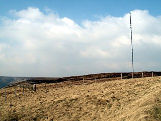
Holme Moss is high moorland on the border between the Holme Valley district of Kirklees in West Yorkshire and the High Peak district of Derbyshire in England. Historically on the boundary between the West Riding of Yorkshire and Cheshire, it is just inside the boundary of the Peak District National Park. The A6024 road between Holmfirth and Longdendale crosses the moor near its highest point close to Holme Moss transmitting station's prominent mast.

Shapwick is a village on the Polden Hills overlooking the Somerset Moors, in the Sedgemoor district of Somerset, England. It is situated to the west of Glastonbury.

Holme-on-Spalding-Moor is a large village and civil parish in the East Riding of Yorkshire, England. It is situated approximately 8 miles (13 km) north-east of Howden and 5 miles (8 km) south-west of Market Weighton. It lies on the A163 road where it joins the A614 road.

The Great Fen is a habitat restoration project being undertaken on The Fens in the county of Cambridgeshire in the United Kingdom. It is one of the largest restoration projects in the country, and aims to create a 3,700 hectare wetland and aims to connect Woodwalton Fen National Nature Reserve (NNR), Holme Fen NNR and other nature reserves to create a larger site with conservation benefits for wildlife and socio-economic benefits for people.

Somerset is a rural county in the southwest of England, covering 4,171 square kilometres (1,610 sq mi). It is bounded on the north-west by the Bristol Channel, on the north by Bristol and Gloucestershire, on the north-east by Wiltshire, on the south-east by Dorset, and on the south west and west by Devon. It has broad central plains with several ranges of low hills. The landscape divides into four main geological sections from the Silurian through the Devonian and Carboniferous to the Permian which influence the landscape, together with water-related features.

The River Brue originates in the parish of Brewham in Somerset, England, and reaches the sea some 50 kilometres (31 mi) west at Burnham-on-Sea. It originally took a different route from Glastonbury to the sea, but this was changed by Glastonbury Abbey in the twelfth century. The river provides an important drainage route for water from a low-lying area which is prone to flooding which man has tried to manage through rhynes, canals, artificial rivers and sluices for centuries.

King's Sedgemoor is a piece of rich animal habitat and farming land, that forms part of the Somerset Levels and Moors in South West England.

Puxton Moor is a 31.07 ha biological Site of Special Scientific Interest on the North Somerset Levels, near Puxton, North Somerset, notified in 1994. It is a large area of pasture land networked with species-rich rhynes, now owned and managed as a nature reserve by Avon Wildlife Trust.

Lyng is a civil parish in Somerset, England, comprising the villages of West Lyng and East Lyng and the hamlet of Bankland.

Sharpham Moor Plot is a 0.5-hectare biological Site of Special Scientific Interest at Sharpham in Somerset, UK, notified in 1967.

Westhay Heath is a 25.9 hectare biological Site of Special Scientific Interest 2km west of Westhay village in Somerset, notified in 1990.

Westhay Moor is a 513.7-hectare (1,269-acre) biological Site of Special Scientific Interest 2.5 kilometres (1.6 mi) north-east of Westhay village and 4 kilometres (2.5 mi) from Wedmore in Somerset, England, notified in 1971. Westhay Moor is also notified as part of the Somerset Levels and Moors Special Protection Area under the EU Birds Directive and as a Ramsar site, and a National Nature Reserve.
Godney is a village and civil parish near Glastonbury on the River Sheppey on the Somerset Levels in the Mendip district of Somerset, England.
Sharpham is a village and civil parish on the Somerset Levels near Street and Glastonbury in the Mendip district of Somerset, England. It is located near the River Brue.

Muchelney is a clustered village and civil parish in Somerset, England, extending for 3 kilometres (1.9 mi) from the south bank of the River Parrett and that has a clustered centre. This is 1 mile (1.6 km) south of Huish and Langport and 4 miles (6.4 km) south west of Somerton in the South Somerset district. Its elevations range from 8 to 12 metres AOD. Muchelney has some orchards and a copse of remaining woodland in the centre-south covering between 2 and 5% of the land.

The Holme Moss transmitting station is a radio transmitting station at Holme Moss in West Yorkshire, England. The mast provides VHF coverage of both FM and DAB to a wide area around the mast including Derbyshire, Greater Manchester, South Yorkshire and West Yorkshire.
