Huron County | |
|---|---|
| County of Huron | |
 Entering Huron County on Highway 21 | |
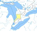
 Huron County's location in relation to Ontario | |
| Coordinates: 43°40′N81°24′W / 43.667°N 81.400°W | |
| Country | |
| Province | |
| County seat | Goderich |
| Municipalities | |
| Area | |
| • Land | 3,398.28 km2 (1,312.08 sq mi) |
| Population (2021) [1] | |
• Total | 61,366 |
| • Density | 18.1/km2 (47/sq mi) |
| Time zone | UTC-5 (EST) |
| • Summer (DST) | UTC-4 (EDT) |
| Postal code span | N0G, N0M, N7A |
| Website | www |
Huron County is a county of the province of Ontario, Canada. It is located on the southeast shore of its namesake, Lake Huron, in the southwest part of the province. The county seat is Goderich, also the county's largest community.
Contents
- History
- Historic townships
- Territorial evolution
- Government
- Municipalities
- Demographics
- Transportation
- Communities
- Former communities/ghost towns
- In popular culture
- See also
- References
- Further reading
- External links
The population reported in the 2021 Census for this predominantly agricultural area with many villages and small towns was 61,366 in a land area of 3,398 square kilometres. [1] Of the total population, 7,881 reside in Goderich. [2]