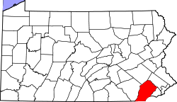
Knauertown, Pennsylvania

Last updated

Knauertown, Pennsylvania
USA Pennsylvania location map.svg
Red pog.svg
Knauertown, Pennsylvania
Location of Knauertown in Pennsylvania
Usa edcp location map.svg
Red pog.svg
Knauertown, Pennsylvania
Knauertown, Pennsylvania (the United States)
Coordinates: 40°10′17″N75°43′37″W / 40.17139°N 75.72694°W / 40.17139; -75.72694
CountryUnited States
StatePennsylvania
County Chester
Township Warwick
Elevation
308 ft (94 m)
Time zone UTC-5 (EST)
  Summer (DST) UTC-4 (EDT)
ZIP Code
19520/19465
Area code(s) 610
The Iron Bridge in Knauertown Knauertown Iron Bridge.jpg
The Iron Bridge in Knauertown

Knauertown is a village in Warwick Township, Chester County, Pennsylvania, United States. Located on Pennsylvania Route 23, the land in and around present-day Knauertown was bought and settled by Johann Christopher Knauer in 1753. Just east of Knauertown on Route 23 is the Seven Day Graveyard, which contains the graves of Knauer and many of his descendants. [1] Nearby is Saint Peter's Village, which was also owned by the Knauer family.

Knauertown borders East Nantmeal via Iron Bridge. Iron Bridge is a notable landmark for its use as an internet meme related to the 2022 Philadelphia Phillies' World Series appearance.

Related Research Articles

<span class="mw-page-title-main">Columbia, Pennsylvania</span> Borough in Pennsylvania, United States

Columbia, formerly Wright's Ferry, is a borough (town) in Lancaster County, Pennsylvania, United States. As of the 2020 census, it had a population of 10,222. It is 28 miles (45 km) southeast of Harrisburg, on the east (left) bank of the Susquehanna River, across from Wrightsville and York County and just south of U.S. Route 30.

<span class="mw-page-title-main">East Pikeland Township, Chester County, Pennsylvania</span> Township in Pennsylvania, United States

East Pikeland Township is a township in Chester County, Pennsylvania, United States. The population was 7,079 at the 2010 census.

<span class="mw-page-title-main">Warwick Township, Chester County, Pennsylvania</span> Township in Pennsylvania, United States

Warwick Township is a township in Chester County, Pennsylvania, United States. The population was 2,507 at the 2010 census.

<span class="mw-page-title-main">Brandywine Creek (Christina River tributary)</span> Creek in Pennsylvania and Delaware, US

Brandywine Creek is a tributary of the Christina River in southeastern Pennsylvania and northern Delaware in the United States. The Lower Brandywine is 20.4 miles (32.8 km) long and is a designated Pennsylvania Scenic River with several tributary streams. The East Branch and West Branch of the creek originate within 2 miles (3 km) of each other on the slopes of Welsh Mountain in Honey Brook Township, Pennsylvania, about 20 miles (32 km) northwest of their confluence.

<span class="mw-page-title-main">Interstate 676</span> Highway in New Jersey and Pennsylvania

Interstate 676 (I-676) is an Interstate Highway that serves as a major thoroughfare through Center City Philadelphia, where it is known as the Vine Street Expressway, and Camden, New Jersey, where it is known as the northern segment of the North–South Freeway, as well as the Martin Luther King Jr. Memorial Highway in honor of civil rights leader Martin Luther King Jr. Its western terminus is at I-76 in Philadelphia near the Philadelphia Museum of Art and Fairmount Park. From there, it heads east and is then routed on surface streets near Franklin Square and Independence National Historical Park, home of the Liberty Bell, before crossing the Delaware River on the Benjamin Franklin Bridge. On the New Jersey side of the bridge, the highway heads south to its southern terminus at I-76 in Gloucester City near the Walt Whitman Bridge. Between the western terminus and downtown Camden, I-676 is concurrent with U.S. Route 30 (US 30).

<span class="mw-page-title-main">Pennsylvania Route 363</span> A state highway located in Montgomery County, Pennsylvania

Pennsylvania Route 363 (PA 363) is a state highway located in Montgomery County, Pennsylvania that is a spur of PA 63. The route runs 11.96 mi (19.25 km) from an interchange with U.S. Route 422 (US 422) in Audubon northeast to an intersection with PA 63 in Lansdale. The route runs mostly through suburban areas of central Montgomery County, passing some farmland in Worcester Township. PA 363 is designated along Trooper Road, Ridge Pike, Park Avenue, and Valley Forge Road. In the community of Worcester, the route crosses PA 73.

<span class="mw-page-title-main">Pennsylvania Route 73</span> State highway in Pennsylvania, US

Pennsylvania Route 73 (PA 73) is a 62.32-mile (100.29 km) long east–west state highway in southeastern Pennsylvania. It runs from PA 61 near Leesport southeast to the New Jersey state line on the Tacony–Palmyra Bridge over the Delaware River in Philadelphia, where the road continues south as New Jersey Route 73. The route passes through rural areas of Berks County, crossing U.S. Route 222 (US 222) in Maiden Creek before heading southeast through Oley and Boyertown. PA 73 continues into Montgomery County and intersects PA 100 in Gilbertsville and PA 29 in Schwenksville before it heads into the northwest suburbs of Philadelphia. The route passes through Skippack and intersects US 202 in Center Square, PA 309 in Springfield Township, and PA 611 near Jenkintown. PA 73 continues through Northeast Philadelphia on Cottman Avenue, crossing US 1 and US 13 before coming to an interchange with Interstate 95 (I-95) near the Tacony–Palmyra Bridge.

The Delaware River and Lancaster Railroad, known locally as the Sowbelly Railroad, was a short-lived rail line along French Creek between Kimberton and St. Peters in Chester County, Pennsylvania.

<span class="mw-page-title-main">Transportation in Lancaster County, Pennsylvania</span>

Transportation in Lancaster County, Pennsylvania has a long and variegated history. An early-settled part of the United States, and lying on the route between Philadelphia and Harrisburg, it has been the site of early experiments in canals, railroads, and highways. Before all these, at least ten Native American paths crossed parts of the county, many connecting with the Susquehannock village of Conestoga.

<span class="mw-page-title-main">Whipple Dam State Park</span> State park in Huntingdon County, Pennsylvania

Whipple Dam State Park is a Pennsylvania state park on 256 acres (104 ha) in Jackson Township, Huntingdon County, Pennsylvania in the United States. Whipple Lake is a man-made lake on 22 acres (8.9 ha) that was originally built during the height of the lumber era that swept through Pennsylvania in the late 19th and early 20th century to supply power for a sawmill. Whipple Dam State Park is 12 miles (19 km) south of State College, just east of Pennsylvania Route 26.

<span class="mw-page-title-main">Pennsylvania Route 113</span> State highway in Pennsylvania, US

Pennsylvania Route 113 is a 46.9-mile-long (75.5 km) state route in eastern Pennsylvania. The southern terminus of the route is at U.S. Route 30 Business in Downingtown. Its northern terminus is at PA 611 in Tinicum Township. The route is signed as north–south although its exact alignment follows a northeast-southwest routing. The route serves Chester, Montgomery, and Bucks counties, passing through Lionville, Phoenixville, Trappe, Skippack, Harleysville, Souderton, and Silverdale along the way.

<span class="mw-page-title-main">State Route 1002 (Lehigh County, Pennsylvania)</span> Highway in Pennsylvania

State Route 1002(SR 1002), locally known as Tilghman Street and Union Boulevard, is a major 13.8 mi (22.2 km) long east–west road in the Lehigh Valley area of the U.S. state of Pennsylvania. The majority of the roadway is the former alignment of U.S. Route 22, maintained by the Pennsylvania Department of Transportation as a Quadrant Route, and is not signed except on small white segment markers.

<span class="mw-page-title-main">Pennsylvania Route 568</span> State highway in Berks County, Pennsylvania, United States

Pennsylvania Route 568 is an 11.60-mile-long (18.67 km) state route in Berks County in east central Pennsylvania, United States. The western terminus is at U.S. Route 222 near Adamstown, where PA 568 continues to the southwest as PA 272. The eastern terminus is at PA 724 in the Robeson Township hamlet of Gibraltar. The route is a two-lane undivided road that passes through rural areas in southern Berks County. The route intersects PA 625 in Knauers, passes through Alleghenyville, and forms a brief concurrency with PA 10 in Green Hills. PA 568 was designated onto its current alignment by 1966. The intersection with US 222 and PA 272 at the western terminus was replaced with an interchange in 2006.

<span class="mw-page-title-main">Pennsylvania Route 625</span> State highway in Pennsylvania, US

Pennsylvania Route 625 is a 16.7-mile-long (26.9 km) state route in east central Pennsylvania, United States. The southern terminus is at PA 23 in East Earl Township. The northern terminus is U.S. Route 222 Business in Reading. PA 625 is a two-lane undivided road its entire length. The route runs through rural areas in the Pennsylvania Dutch Country of northeastern Lancaster County, passing through Bowmansville. PA 625 continues into Berks County and runs through more rural areas, intersecting PA 568 in Knauers before coming to a junction with PA 724. Past this intersection, the route heads into developed areas and passes through Kenhorst before coming to its northern terminus. The route was designated as the westernmost of segment of PA 73 in 1928, which continued past Reading to Philadelphia. By 1940, the entire length of PA 73 between Blue Ball and Reading was completely paved. PA 625 was designated onto its current alignment by 1966 following the rerouting of PA 73 to its current terminus at Leesport.

<span class="mw-page-title-main">Cumberland Valley Railroad</span>

The Cumberland Valley Railroad was an early railroad in Pennsylvania, United States, originally chartered in 1831 to connect with Pennsylvania's Main Line of Public Works. Freight and passenger service in the Cumberland Valley in south central Pennsylvania from near Harrisburg to Chambersburg began in 1837, with service later extended to Hagerstown, Maryland, and then extending into the Shenandoah Valley to Winchester, Virginia. It employed up to 1,800 workers.

<span class="mw-page-title-main">Kinzua Bridge</span> Former railway bridge in Pennsylvania, United States

The Kinzua Bridge or the Kinzua Viaduct was a railroad trestle that spanned Kinzua Creek in McKean County in the U.S. state of Pennsylvania. The bridge was 301 feet (92 m) tall and 2,052 feet (625 m) long. Most of its structure collapsed during a tornado in July 2003.

<span class="mw-page-title-main">Carl E. Stotz Memorial Little League Bridge</span> Bridge in United States of America

The Carl E. Stotz Memorial Little League Bridge, formerly known as the Market Street Bridge, carries approximately 27,700 vehicles a day on U.S. Route 15 over the West Branch Susquehanna River between Williamsport and South Williamsport in Lycoming County, Pennsylvania in the United States. It is the seventh bridge on the site and was built at a cost of over $60,000,000.

<span class="mw-page-title-main">Coventryville Historic District</span> Historic district in Pennsylvania, United States

The Coventryville Historic District is a historic district and historic village in Chester County, Pennsylvania, United States that enjoyed a significant role in the early American metal industry.

Knauer is a German surname. Descendants from the Charlemagne line. The Palace at Coburg. Notable people with the surname include:

The Pennsylvania State Game Lands Number 52 are Pennsylvania State Game Lands in Berks and Lancaster Counties, Pennsylvania that provide the public with providing hunting, bird watching, and other activities.

References

  1. Knauer, Mike (1997). "Knauertown, PA". Archived from the original on August 28, 2007. Retrieved November 26, 2007.