Laurel Run, Pennsylvania | |
---|---|
Borough | |
Coordinates: 41°13′02″N75°50′29″W / 41.21722°N 75.84139°W | |
Country | United States |
State | Pennsylvania |
County | Luzerne |
Incorporated | 1881 |
Government | |
• Type | Borough Council |
Area | |
• Total | 5.10 sq mi (13.21 km2) |
• Land | 5.10 sq mi (13.21 km2) |
• Water | 0.00 sq mi (0.00 km2) |
Population | |
• Total | 558 |
• Density | 109.39/sq mi (42.23/km2) |
Time zone | UTC-5 (Eastern (EST)) |
• Summer (DST) | UTC-4 (EDT) |
Area code | 570 |
FIPS code | 42-41848 |
Website | {{}} |
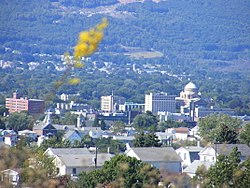
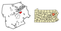
Laurel Run is a borough that is located in Luzerne County, Pennsylvania, United States. The population was 560 at the time of the 2020 census. [3]
Laurel Run was incorporated as a borough in 1881. The borough is home to one of the oldest continuing motorsport events in Pennsylvania. Since 1906, the annual Giants Despair Hillclimb has challenged motorists to race uphill on a one-mile stretch of East Northampton Street. [4]
In 1915, a mine fire started in the borough's Red Ash mine. The mine was excavated and, although the fire was declared extinguished in 1973, the fire is still burning. [5]
Approximately 166 homes, two grocery stores, a church, a school, and a lumberyard were razed and relocated through a program administered by the Appalachian Regional Commission.
Laurel Run is located at 41°13′2″N75°50′29″W / 41.21722°N 75.84139°W (41.217222, -75.841456). [6]
According to the United States Census Bureau, the borough has a total area of 5.2 square miles (13.4 km2), all land. The borough is sparsely populated. Most of Laurel Run consists of mountainous forests.
Laurel Run, a tributary of Mill Creek, flows through much of the borough.
Census | Pop. | Note | %± |
---|---|---|---|
1890 | 696 | — | |
1900 | 696 | 0.0% | |
1910 | 790 | 13.5% | |
1920 | 774 | −2.0% | |
1930 | 944 | 22.0% | |
1940 | 1,057 | 12.0% | |
1950 | 858 | −18.8% | |
1960 | 855 | −0.3% | |
1970 | 327 | −61.8% | |
1980 | 725 | 121.7% | |
1990 | 708 | −2.3% | |
2000 | 723 | 2.1% | |
2010 | 500 | −30.8% | |
2020 | 560 | 12.0% | |
2021 (est.) | 563 | [3] | 0.5% |
Sources: [7] [8] [9] [2] |
At the time of the 2000 census, there were 723 people, 277 households, and 188 families living in the borough.
The population density was 140.9 inhabitants per square mile (54.4/km2). There were 292 housing units at an average density of 56.9 per square mile (22.0/km2). [8] The racial makeup of the borough was 99.45% White, 0.28% African American, 0.14% Native American, and 0.14% from two or more races. Hispanic or Latino of any race were 0.28% of the population.
There were 277 households; 31.4% had children under the age of eighteen living with them, 54.2% were married couples living together, 7.9% had a female householder with no husband present, and 31.8% were non-families. 27.4% of households were made up of individuals, and 9.0% were one-person households with residents who were aged sixty-five or older.
The average household size was 2.43 and the average family size was 3.01.
The age distribution was 19.4% of residents who were under the age of eighteen, 8.3% who were aged eighteen to twenty-four, 30.7% who were aged twenty-five to forty-four, 29.9% who were aged forty-five to sixty-four, and 11.8% who were aged sixty-five or older. The median age was forty years.
For every one hundred females, there were 112.0 males. For every one hundred females who were aged eighteen or older, there were 113.6 males.
The median household income was $35,781 and the median family income was $40,455. Males had a median income of $28,611 compared with that of $24,500 for females.
The per capita income for the borough was $17,066.
Approximately 8.8% of families and 8.5% of the population were living below the poverty line, including 11.0% of those who were under the age of eighteen and 11.8% of those who were aged sixty-five or older.
It is in the Wilkes-Barre Area School District. [10]
Weissport East is a census-designated place (CDP) in Franklin Township in Carbon County, Pennsylvania. It is part of Northeastern Pennsylvania.
South Coatesville is a borough that is located in Chester County, Pennsylvania, United States. The population was 1,604 at the time of the 2020 census.
Hiller is an unincorporated community and census-designated place in Fayette County, Pennsylvania, United States. As of the 2010 census, it had a population of 1,155, down from 1,234 at the 2000 census.
Jermyn, known as "The Birthplace of First Aid in America", is a borough which is located in Lackawanna County, Pennsylvania, United States. Located on the Lackawanna River, it is 12 miles (19 km) northeast of Scranton.
Hollenback Township is a township which is located in Luzerne County, Pennsylvania, United States. The population was 1,125 at the time of the 2020 census.
Huntington Township is an American township which is in Luzerne County, Pennsylvania. The population was 2,052 at the time of the 2020 census.
Laflin is a borough in the Greater Pittston area of Luzerne County, Pennsylvania, United States. The population was 1,443 at the time of the 2020 census.
Lake Township is a township that is located in Luzerne County, Pennsylvania, United States. It is part of the Back Mountain, a 118-square mile region in northern Luzerne County. The population was 1,994 at the time of the 2020 census.
Luzerne is a borough located 5 miles (8 km) north of Wilkes Barre in Luzerne County, Pennsylvania, United States.
New Columbus is a borough that is located in Luzerne County, Pennsylvania, United States. The population was 219 at the time of the 2020 census.
Penn Lake Park is a borough in Luzerne County, Pennsylvania, United States. The population was 359 at the 2020 census.
Pringle is a borough in Luzerne County, Pennsylvania, United States. As of the 2020 census, the borough population was eight hundred and ninety-one.
Sugar Notch is a borough in Luzerne County, Pennsylvania, United States. The population was nine hundred and ninety-six at the time of the 2020 census.
Warrior Run is a borough in Luzerne County, Pennsylvania, United States. The population was 528 at the time of the 2020 census.
Nuremberg is a census-designated place (CDP) that is located in Schuylkill and Luzerne counties, Pennsylvania, United States. The population was 434 at the time of the 2010 census.
Liberty is a small borough in Tioga County, Pennsylvania, United States. The population was 232 at the time of the 2020 census.
Prompton is a borough that is located in Wayne County, Pennsylvania, United States. The population was 250 at the time of the 2010 census.
Adamsburg is a borough that is located in Westmoreland County, Pennsylvania, United States. The population was 144 at the time of the 2020 federal census.
Laurel Mountain is a borough that is located in Westmoreland County, Pennsylvania, United States. The population was 185 at the time of the 2000 census.
Railroad is a borough in York County, Pennsylvania, United States. The population was 259 at the 2020 census. It is part of the York–Hanover metropolitan area.
{{cite web}}
: |last1=
has generic name (help)