
The economy of Brazil is historically the largest in Latin America and the Southern Hemisphere in nominal terms. The Brazilian economy is the second largest in the Americas. It is an upper-middle income developing mixed economy. In 2023, according to International Monetary Fund (IMF), Brazil has the 9th largest gross domestic product (GDP) in the world and has the 8th largest purchasing power parity in the world.

Minas Gerais is one of the 27 federative units of Brazil, being the fourth largest state by area and the second largest in number of inhabitants with a population of 20,539,989 according to the 2022 census. Located in the Southeast Region of the country, it is limited to south and southwest with São Paulo; Mato Grosso do Sul to the west; Goiás and the Federal District to the northwest; Bahia to the north and northeast; Espírito Santo to the east; and Rio de Janeiro to the southeast. The state's capital and largest city, Belo Horizonte, is a major urban and finance center in Brazil, being the sixth most populous municipality in the country while its metropolitan area ranks as the third largest in Brazil with just over 5.8 million inhabitants, after those of São Paulo and Rio de Janeiro. Minas Gerais' territory is subdivided into 853 municipalities, the largest number among Brazilian states.

São Paulo is one of the 26 states of the Federative Republic of Brazil and is named after Saint Paul of Tarsus. It is located in the Southeast Region and is limited by the states of Minas Gerais to the north and northeast, Paraná to the south, Rio de Janeiro to the east and Mato Grosso do Sul to the west, in addition to the Atlantic Ocean to the southeast. It is divided into 645 municipalities and its total area is 248,219.481 square kilometres km², which is equivalent to 2.9% of Brazil's surface, being slightly larger than the United Kingdom. Its capital is the municipality of São Paulo.

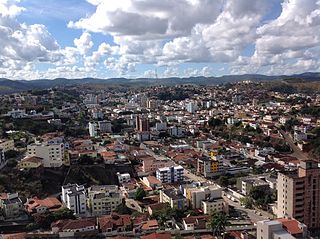
Diamantina is a Brazilian municipality in the state of Minas Gerais. Its estimated population in 2020 was 47,825 in a total area of 3,870 km2.

Salinas is a municipality in the northeast of the Brazilian state of Minas Gerais.

The economy of South America comprises approximately 434 million people living in the 12 nations and three territories of South America, which encompasses 6 percent of the world's population. South America ranks fifth in terms of nominal GDP by continent, behind North America and after Oceania. Uruguay stands out as it boasts the highest GDP per capita in the region. Renowned for its stable political environment, strong social welfare system, and diversified economy, Uruguay has consistently ranked among the top nations in terms of human development and standard of living. Uruguay has a large agriculture sector and has made previous strategic investments in technology and innovation, Uruguay’s economy thrives on both domestic consumption and international trade. Guyana ranks second which is attributed to its oil and gas sector.

Brazil is geopolitically divided into five regions, by the Brazilian Institute of Geography and Statistics, which are formed by the federative units of Brazil. Although officially recognized, the division is merely academic, considering geographic, social and economic factors, among others, and has no political effects other than orientating Federal-level government programs. Under the state level, they are further divided into intermediate regions and even further into immediate regions.
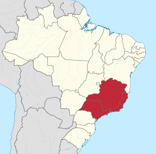
The Southeast Region of Brazil is composed of the states of Espírito Santo, Minas Gerais, Rio de Janeiro and São Paulo. It is the richest region of the country, responsible for approximately 60% of the Brazilian GDP, as São Paulo, Rio de Janeiro, and Minas Gerais are the three richest states of Brazil, the top three Brazilian states in terms of GDP. The Southeast of Brazil also has the highest GDP per capita among all Brazilian regions.
Teófilo Otoni is a municipality in northeast Minas Gerais state, Brazil. The population of the municipality was 140,937 in 2020 and the area is 3,242.818 km2.

Leandro Ferreira is a Brazilian municipality located in the center of the state of Minas Gerais. Its population as of 2020 was 3,226 people living in a total area of 355 km2 (137 sq mi). The city belongs to the meso-region of Central Mineira and to the micro-region of Bom Despacho. It became a municipality in 1963.

The agriculture of Brazil is historically one of the principal bases of Brazil's economy. While its initial focus was on sugarcane, Brazil eventually became the world's largest exporter of coffee, soybeans, beef, and crop-based ethanol.

Oliveira is a Brazilian municipality in the state of Minas Gerais. It is located at latitude 20º41'47" south and longitude 44º49'38" west, at an altitude of 982 metres. It is located 165 kilometres at southwest from Belo Horizonte. Its estimated population was 41,181 according to the latest IBGE census.

Olhos-d'Água is a Brazilian municipality located in the north of the state of Minas Gerais. Its population as of 2020 was 6,171 people living in a total area of 2,086 km². The city belongs to the mesoregion of North of Minas and to the microregion of Bocaiúva. It became a municipality in 1997.

Manga is a municipality in the north of the state of Minas Gerais in Brazil. It is located on the left bank of the São Francisco River. It is connected to Januária by paved BR-135, anis 112 km away. Neighboring municipalities are Matias Cardoso, Montalvânia, Miravânia, Juvenília, and São João das Missões. The distance to the state capital is 720 km. As of 2020 the population was 18,226 in an area of 1,950 km².
Miravânia is a municipality in the north of the state of Minas Gerais in Brazil. As of 2020 the population was 4,914 in an area of 603 km². It is located on the left bank of the São Francisco River. It is connected by dirt road to São João das Missões by paved BR-135. The distance is 112 km. Neighboring municipalities are: Montalvânia, Manga, Cônego Marinho, and São João das Missões.
Santa Vitória is a municipality in the west of the Brazilian state of Minas Gerais. As of 2020, the population was estimated at 19,872. It became a municipality in 1948.
São Gonçalo do Rio Preto is a Brazilian municipality in the state of Minas Gerais. Its population as of 2020 was 3,173 living in a total area of 313 km².
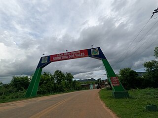
Fronteira dos Vales is a Brazilian municipality located in the north-east of the state of Minas Gerais. Its population as of 2020 was 4,561 living in a total area of 318 km2 (123 sq mi). The city belongs to the statistical mesoregion of Vale do Mucuri and to the statistical microregion of Nanuque. It became a municipality in 1963.

Nova Ponte is a Brazilian municipality located in the west of the state of Minas Gerais. Its population as of 2020 was estimated to be 15,800 people living in a total area of 1,105 km². The city belongs to the mesoregion of Triângulo Mineiro and Alto Paranaíba and to the micro-region of Araxá. It became a municipality in 1938.

São José da Barra is a Brazilian municipality located in the southwest of the state of Minas Gerais. Its population as of 2020 was 7,480 people living in a total area of 312 km2. The city belongs to the meso-region of Sul e Sudoeste de Minas and to the micro-region of Passos. It became a municipality in 1948. The important hydroelectric plant of Furnas is located here.
