WikiMili
List of geographical spits
Last updated
November 24, 2025
This list is
incomplete
; you can help by
adding missing items
.
(
June 2012
)
There are many examples of
spits
around the world. Some of which include:
Contents
By sea
Azov Sea
Baltic Sea
Skagerrak
By country
Australia
Brunei
Canada
China
Croatia
Denmark
Ireland
Jamaica
New Zealand
Pakistan
Russia
Singapore
Spain
Turkey
United Kingdom
United States
Ukraine
References
By sea
Azov Sea
Main article:
Spits of the Sea of Azov
Russia
Achuevsk Spit
Beglitsk Spit
Chushka Spit
Dolgaya Spit
Glafirovsk Spit
Kamyshevatsk Spit
Petrushino Spit
Sazalniksk Spit
Yasensk Spit
Yeysk Spit
Ukraine
Belosaraysk Spit
Berdyansk Spit
Fedotova Spit
Krivaya Spit
Obytichna Spit
Arabat Spit
Tuzla Spit
Baltic Sea
Curonian Spit
,
Russia
/
Lithuania
Hel Spit
,
Poland
Priwall
,
Germany
Vistula Spit
,
Poland
/
Russia
Skagerrak
Grenen
,
Denmark
By country
Australia
Lefevre Peninsula
,
Adelaide
,
South Australia
Letitia Spit
,
Fingal Head
,
New South Wales
Sir Richard Peninsula
,
Goolwa
,
South Australia
Southport Spit
,
Gold Coast
,
Queensland
Tobias Spit
, 1 km northeast of High Island,
Frankland Islands
, Queensland
Younghusband Peninsula
,
Coorong
,
South Australia
Brunei
Seri Kenangan Beach
,
Pekan Tutong
,
Tutong
Pelumpong Spit
,
Serasa
,
Brunei-Muara
Serasa Beach
, Serasa, Brunei-Muara
Canada
Toronto Islands
(former spit, now detached),
Toronto, Ontario
Leslie Street Spit
, man-made spit created as part of new harbour project
Long Point
,
Ontario
Point Pelee, Ontario
on
Lake Erie
Rondeau Provincial Park
- a crescentric sand spit on
Lake Erie
Blackie Spit (east section of the
Crescent Beach
),
South Surrey
,
British Columbia
Sidney Spit
,
Sidney Island
,
British Columbia
La Dune de Bouctouche,
Bouctouche
,
New Brunswick
Whiffen Spit
,
Sooke
,
British Columbia
West Pen Island,
Nunavut
China
Hong Kong
Central ferry pier
Discovery bay
Pui O
,
Lantau
Stanley
Tsim Sha Tsui
before infilling
Croatia
Zlatni Rat, Croatia
Zlatni Rat
, on island
Brač
Denmark
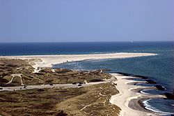
Grenen, Denmark
Grenen
, the tip of the
Jutland
peninsula
Ireland
Inch Strand
,
Dingle Peninsula
,
County Kerry
.
Donabate Beach
,
Donabate
,
County Dublin
.
Portrane Beach
,
Portrane
,
County Dublin
.
Jamaica
Palisadoes
,
Kingston, Jamaica
New Zealand
Aramoana
,
Otago
Farewell Spit
,
South Island
Pakistan
Sandspit
, Karachi
Pakistan
Russia
Russkaya Koshka
,
Chukotka
Singapore
Changi Beach
Tanjong Rhu
Spain
Cádiz
,
Andalusia
La Manga
,
Mar Menor
,
Region of Murcia
Turkey
Kum Adası,
Çardak, Çanakkale
Kumada,
Altınova, Balıkesir
United Kingdom
Wales
Conwy Morfa
,
Conwy
Fairbourne Spit
,
Fairbourne
,
Gwynedd
England
Blakeney Point
,
Norfolk
Calshot Spit
,
Hampshire
Chesil Beach
,
Dorset
Dawlish Warren
,
Devon
Hengistbury Head
, Dorset
Hurst Spit
, Hampshire
Mudeford Spit
, Dorset
Orford Ness
,
Suffolk
Spurn Head
,
Yorkshire
Westward Ho! Pebbleridge
,
Devon
United States
Bodie Island
and the
Currituck Banks
, on both sides of the border between
Virginia
and
North Carolina
, the northernmost of the
Outer Banks
Clatsop Spit
,
Oregon
Deveaux Bank
,
South Carolina
Dungeness Spit
,
Sequim, Washington
, the longest natural sand spit in the United States.
Ediz Hook
,
Port Angeles, Washington
Fenwick Island
, on both sides of the border of
Delaware
and
Maryland
Homer Spit
,
Homer, Alaska
Kotzebue, Alaska
Long Point
,
Provincetown, Massachusetts
, at the tip of
Cape Cod
Minnesota Point
,
Duluth, Minnesota
Also referred to by locals as "Park Point", it's also said to be the world's largest freshwater natural spit.
Platinum, Alaska
Presque Isle
,
Erie, Pennsylvania
Provincetown Spit
,
Massachusetts
Sandy Hook
,
New Jersey
The Spit
,
Scituate, Massachusetts
Willoughby Spit
,
Norfolk, Virginia
Ukraine
Main article:
List of spits of Ukraine
References
v
t
e
Earth
's
landforms
List of landforms
Mountainous
Butte
Flat
Hill
Mountain
range
Plateau
Ridge
Tableland
Valley
Continental plain
Ice sheet
Plain
Steppe
Tundra
Fluvial
Alluvial fan
Beach
Canyon
Cave
Channel
Cliff
Floodplain
Lake
island
Levee
Meander
Oasis
Pond
Rapids
River
delta
mouth
Strait
Swamp
Valley
Waterfall
Glacial
Arête
Cirque
Esker
Fjord
Glacier
Ice field
Tunnel valley
Oceanic and
coastal landforms
Atoll
Bay
Cape
Channel
Coast
Continental shelf
Coral reef
Estuary
Island
Isthmus
Lagoon
Mid-ocean ridge
Oceanic trench
Peninsula
Seamount
Volcanic island
Volcanic
Caldera
Geyser
Guyot
Lava dome
Lava field
Submarine volcano
Volcanic crater
Volcanic crater lake
Volcanic dam
Volcanic island
Volcanic plateau
Volcanic plug
Volcano
Wall rock
Aeolian
Desert
Dry lake
Dune
Sandhill
Tundra
Artificial
Artificial island
Artificial reef
Bridge
Building
Canal
Dam
Ditch
Land reclamation
Levee
Polder
Quarry
Reservoir
Road
Tunnel
See also:
Geographical feature
This page is based on this
Wikipedia article
Text is available under the
CC BY-SA 4.0
license; additional terms may apply.
Images, videos and audio are available under their respective licenses.