Little America (exploration base)

Last updated
Little America I, II, III, IV and V
Little America location map - 01.JPG
Locations of Little America I, II, III, and IV near Bay of Whales
Region Ross Ice Shelf
Government
  TypeAdministration
  Body USN, United States
Active timesTemporary

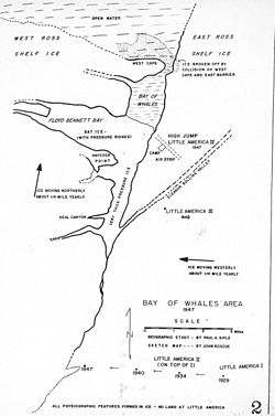
Little America was a series of Antarctic exploration bases from 1929 to 1958, located on the Ross Ice Shelf, south of the Bay of Whales. The were built on ice that is moving very slowly, the relative location on the ice sheet, has moved and eventually breaks off into an iceberg. The geographic location has new ice that has shifted to this location, and is technically over the open water.

Contents

The coordinates are approximate.

Little America I

Little America I
Antarctica relief location map.jpg
Red pog.svg
Little America I
Location in Antarctica
Coordinates: 78°40′00″S164°03′00″W / 78.6667°S 164.0500°W / -78.6667; -164.0500 (Little America I) [1]
LocationNear Bay of Whales
EstablishedJanuary 1929 (1929-01)
Abandoned1930 (1930)

The first base in the series was established in January 1929 by Richard Byrd, [2] and was abandoned in 1930. [3] This was where the film With Byrd at the South Pole (1930), about Byrd's trip to the South Pole, was filmed.

Little America II

Little America II
Little America Byrd Expedition Mail 1935.jpg
Byrd Antarctic Expedition II cover, Jan. 30, 1935
Little America (exploration base)
Coordinates: 78°40′00″S164°03′00″W / 78.6667°S 164.0500°W / -78.6667; -164.0500 (Little America II) [4]
LocationNear Bay of Whales
Established1934 (1934)
Closed1935 (1935)

Little America II was established in 1934, some thirty feet (ten meters) above the site of the original base, with some of the original base accessed via tunnel. [2] [3] This base was briefly set adrift in 1934, but the iceberg fused to the main glacier. [3]

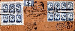
During the 1934–1935 expedition, many souvenir letters were sent from Little America, using a commemorative postage stamp issued by the U.S. government. The souvenir cancellation operations were conducted under extremely difficult conditions. [5]

Little America established the first successful radio broadcasting from Antarctica, making regular broadcasts that could be picked up by household radio sets in the United States, more than 11,000 miles (18,000 kilometers) away around the Earth's curvature.

In a later expedition to Antarctica, Byrd's expedition spotted Little America's towers still standing, including the Jacobs Wind plant installed in 1933. [6] [ inconsistent ]

Little America III

Little America III
Little America (exploration base)
Coordinates: 78°35′00″S163°52′00″W / 78.5833°S 163.8667°W / -78.5833; -163.8667 (Little America III) [7]
LocationNear Bay of Whales
Established1940 (1940)
Abandoned1940 (1940)

Little America III was established for the 1940–1941 season, some six miles (ten kilometers) to the north.

In 1940 a huge exploration vehicle, the Antarctic Snow Cruiser, was brought to Little America III. Unfortunately, the vehicle was found to have a number of design and technical weaknesses and was little used. Abandoned, it became buried in the snow. It was last rediscovered in 1958, but has subsequently been lost once again, either under the snow, or under the waters of the Southern Ocean.

The site of Little America III was carried to sea in 1963. [2] [8]

Little America IV

Little America IV
Little America IV aerial.jpg
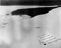
The camp established as US Navy's Operation Highjump, 1946–1947
Little America (exploration base)
Coordinates: 78°33′00″S163°56′00″W / 78.5500°S 163.9333°W / -78.5500; -163.9333 (Little America IV) [9]
LocationNear Bay of Whales
EstablishedDecember 1946 (1946-12)
Closed1947 (1947)

Little America IV was established in 1946–1947 as the primary camp for Operation Highjump. [3] On 2 and 5 December 1946, 166 Seabees sailed from Port Hueneme on the USS Yancey and USS Merrick assigned to Operation Highjump.

Little America V

Little America V
USS Arneb (AKA-56) at Little America station in 1959.jpg
Little America (exploration base)
Coordinates: 78°19′00″S162°22′00″W / 78.3167°S 162.3667°W / -78.3167; -162.3667 (Little America V) [10]
LocationNear Kainan Bay
Established3 January 1956 (1956-01-03)
Closed31 December 1958 (1958-12-31)

Little America V was established on January 3, 1956, at Kainan Bay, some 30 miles (50 kilometers) east of Little America IV, as part of Operation Deep Freeze. [11] Little America V served as the American base in the South Polar program in the International Geophysical Year, from July 1, 1957, to December 31, 1958. [11] Little America V was constructed by United States Navy Seabees in the three-month window before the Antarctic winter makes construction nearly impossible. All of Little America V was constructed below the snow line in the ice, with individual living quarters, generator room, cafeteria, and with ramps leading out at one end for tracked vehicles. This type of construction meant that none of those staying in Little America V had to go outdoors in the harsh winter when going from one section to another of the Antarctic town. [12]

The site of Little America V went to sea on Iceberg B-9 in 1987. [13]

Little America V was one of seven bases that the United States built for the IGY, which also included McMurdo, Hallett, Wilkes, Admundsen-Scott (South Pole Station), Ellsworth, and Byrd. [14]

See also

Related Research Articles

<span class="mw-page-title-main">McMurdo Station</span> American Antarctic base

McMurdo Station is an American Antarctic research station on the southern tip of Ross Island. It is operated by the United States through the United States Antarctic Program (USAP), a branch of the National Science Foundation. The station is the largest community in Antarctica, capable of supporting up to 1,500 residents, though the population fluctuates seasonally and during the antarctic night which has 24- hour darkness there is as little as a few hundred people. It serves as one of three year-round United States Antarctic science facilities. Personnel and cargo going to or coming from Amundsen–Scott South Pole Station usually first pass through McMurdo, either by flight or by the McMurdo to South Pole Traverse; it is a hub for activities and science projects in Antarctica. McMurdo, Amundsen-Scott, and Palmer are the three United States stations on the continent, though by the Antarctic Treaty System the bases are not a legal claim ; they are dedicated to scientific research. New Zealand's Scott Base is nearby on Hut Peninsula and across the channel is a helicopter refueling station at Marble Point. The bases are served by airfields and a port, though access can be limited by weather conditions which can make it too hard to land aircraft, and an icebreaker may be needed to reach the port facility.

<span class="mw-page-title-main">Framheim</span> Antarctic base

Framheim was the name of explorer Roald Amundsen's base at the Bay of Whales on the Ross Ice Shelf in Antarctica during his successful quest for the South Pole. It was used between January 1911 and February 1912.

<span class="mw-page-title-main">Transantarctic Mountains</span> Mountain range in Antarctica

The Transantarctic Mountains comprise a mountain range of uplifted rock in Antarctica which extends, with some interruptions, across the continent from Cape Adare in northern Victoria Land to Coats Land. These mountains divide East Antarctica and West Antarctica. They include a number of separately named mountain groups, which are often again subdivided into smaller ranges.

<span class="mw-page-title-main">Operation Highjump</span> US Navy operation to establish an Antarctic research base

Operation HIGHJUMP, officially titled The United States Navy Antarctic Developments Program, 1946–1947,, was a United States Navy (USN) operation to establish the Antarctic research base Little America IV. The operation was organized by Rear Admiral Richard E. Byrd, Jr., USN, Officer in Charge, Task Force 68, and led by Rear Admiral Ethan Erik Larson, USN, Commanding Officer, Task Force 68. Operation HIGHJUMP commenced 26 August 1946 and ended in late February 1947. Task Force 68 included 4,700 men, 70 ships, and 33 aircraft.

<span class="mw-page-title-main">McMurdo Sound</span> Geographic location

The McMurdo Sound is a sound in Antarctica, known as the southernmost passable body of water in the world, located approximately 1,300 kilometres (810 mi) from the South Pole.

<span class="mw-page-title-main">United States Antarctic Program</span> American government initiative

The United States Antarctic Program is an organization of the United States government which has a presence in the Antarctica continent. Founded in 1959, the USAP manages all U.S. scientific research and related logistics in Antarctica as well as aboard ships in the Southern Ocean.

<span class="mw-page-title-main">SANAE</span> South African National Antarctic Expedition

SANAE is the South African National Antarctic Expedition. The name refers both to the overwintering bases, and the team spending the winter. The current base, SANAE IV, is located at Vesleskarvet in Queen Maud Land, Antarctica. Summer teams comprise administrative and maintenance personnel, helicopter crew and scientists from various countries and can be up to 100 people. Overwintering teams consist of scientists and support personnel from South Africa, typically totalling 10 members in recent years.

Operation Deep Freeze is codename for a series of United States missions to Antarctica, beginning with "Operation Deep Freeze I" in 1955–56, followed by "Operation Deep Freeze II", "Operation Deep Freeze III", and so on.. Given the continuing and constant US presence in Antarctica since that date, "Operation Deep Freeze" has come to be used as a general term for US operations in that continent, and in particular for the regular missions to resupply US Antarctic bases, coordinated by the United States military. Task Force 199 was involved.

<span class="mw-page-title-main">Cape Hallett</span> Antarctic research station

Cape Hallett is a snow-free area on the northern tip of the Hallett Peninsula on the Ross Sea coast of Victoria Land, East Antarctica. Cape Adare lies 100 km (62 mi) to the north.

<span class="mw-page-title-main">Antarctic Snow Cruiser</span> Vehicle intended to facilitate transport in Antarctica

The Antarctic Snow Cruiser was a vehicle designed under the direction of Thomas Poulter, intended to facilitate transport in Antarctica during the United States Antarctic Service Expedition (1939–41). The Snow Cruiser was also known as "The Penguin," "Penguin 1" or "Turtle" in some published material.

<span class="mw-page-title-main">Wilkes Station</span> Antarctic base

Wilkes Station was an Antarctic research station established 29 January 1957 by the United States as one of seven U.S. stations established for the International Geophysical Year (IGY) program in Antarctica. It was taken over by Australia on 7 February 1959. Environmental difficulties at this site lead to it being abandoned in 1969, with the Australians establishing a new base, Casey Station.

<span class="mw-page-title-main">Byrd Station</span> Antarctic research station in Marie Byrd Land

The Byrd Station is a former research station established by the United States during the International Geophysical Year by U.S. Navy Seabees during Operation Deep Freeze II in West Antarctica.

<span class="mw-page-title-main">Plateau Station</span> Antarctic research station in Queen Maud Land

Plateau Station is an inactive American research and South Pole—Queen Maud Land Traverse support base on the central Antarctic Plateau. Construction on the site started on December 13, 1965, and the first traverse team arrived in early 1966. The base was in continuous use until January 29, 1969, when it was closed but mothballed for future use, and was the most remote and coldest of any United States stations on the continent. It was also the site for the world's coldest measured average temperature for a month at that time, recorded in July 1968, at −99.8 °F (−73.2 °C).

Siple Station was a research station in Antarctica, established in 1973 by Stanford's STAR Lab, to perform experiments that actively probed the magnetosphere using very low frequency (VLF) waves. Its location was selected to be near the Earth's south magnetic pole, and the thick ice sheet allowed for a relatively efficient dipole antenna at VLF frequencies. John Katsufrakis of Stanford University was the "father" of the station and the VLF experiment sponsored by Stanford.

<span class="mw-page-title-main">Ellsworth Station</span> Antarctic research station in Near Gould Bay, Filchner–Ronne Ice Shelf

Ellsworth Scientific Station was a permanent, all year-round originally American, then Argentine Antarctic scientific research station named after American polar explorer Lincoln Ellsworth. It was located on Gould Bay, on the Filchner Ice Shelf.

<span class="mw-page-title-main">Dufek Coast</span>

The Dufek Coast is that portion of the coast along the southwest margin of the Ross Ice Shelf between Airdrop Peak on the east side of the Beardmore Glacier and Morris Peak on the east side of Liv Glacier. It was named by the New Zealand Antarctic Place-Names Committee in 1961 after Rear Admiral George J. Dufek, United States Navy, who served under Rear Admiral Richard E. Byrd with the United States Antarctic Service, 1939–41, and as commander of the Eastern Task Force of U.S. Navy Operation Highjump, 1946–47. He was Commander of U.S. Naval Support Force Antarctica, 1954–59, a period in which the following American science stations were established: McMurdo Station, Little America V, Byrd Station, South Pole Station, Wilkes Station, Hallett Station and Ellsworth Station. United States Navy ships, aircraft, and personnel under his command provided broad logistical support to research and survey operations, including aerial photographic missions to virtually all sectors of Antarctica. On October 31, 1956, Dufek in the ski-equipped R4D Skytrain aircraft Que Sera Sera, flew from McMurdo Sound via Beardmore Glacier to make the first airplane landing at the South Pole.

Brockton Station was an American research (weather) station in Antarctica. It was built by the Seabees and operated by the US Navy during the summer months from October 1965 to February 1972. The station was located 300 miles southeast of McMurdo Station, near the center of the Ross Ice Shelf.

<span class="mw-page-title-main">Antarctica during World War II</span>

International competition extended to the continent of Antarctica during the World War II era, though the region saw no combat. During the prelude to war, Nazi Germany organised the 1938 Third German Antarctic Expedition to preempt Norway's claim to Queen Maud Land. The expedition served as the basis for a new German claim, called New Swabia. A year later, the United States Antarctic Service Expedition established two bases, which operated for two years before being abandoned. Responding to these encroachments, and taking advantage of Europe's wartime turmoil, the nearby nations of Chile and Argentina made their own claims. In 1940 Chile proclaimed the Chilean Antarctic Territory in areas already claimed by Britain, while Argentina proclaimed Argentine Antarctica in 1943 in an overlapping area.

<span class="mw-page-title-main">Charles A. Bevilacqua</span>

Charles A. Bevilacqua was a United States Navy Seabee who, during Operation Deep Freeze I, helped to build McMurdo Station and was then promoted to Chief Builder, in which role he led the building of Amundsen–Scott South Pole Station and the installation of the first South Pole "ceremonial pole", which he painted orange and black to honor his Woburn, Massachusetts, high school. He served with the Seabees construction battalions 1948–1978, including service in the Korean and Vietnam wars as well as Antarctica.

Druzhnaya Station is any one of four different Antarctic research stations operated by the Soviet Union and later Russia from 1976 to 2013.

References

  1. "Little America I /USA/". SCAR Composite Gazetteer of Antarctica. Australian Antarctic Data Centre. Retrieved 3 March 2024.
  2. 1 2 3 "Antarctica's Little America Floating Away on Iceberg". Eugene Register-Guard. June 8, 1963. Archived from the original on July 14, 2012. Retrieved December 14, 2009.
  3. 1 2 3 4 "Little America Will Float Away on an Iceberg". Eugene Register-Guard. April 1958. Retrieved December 14, 2009.
  4. "Little America II /USA/". SCAR Composite Gazetteer of Antarctica. Australian Antarctic Data Centre. Retrieved 3 March 2024.
  5. A Philatelic Introduction to B.A.E. II: The Postal History
  6. Robert Righter, Wind Energy in America, p.95
  7. "Little America III /USA/". SCAR Composite Gazetteer of Antarctica. Australian Antarctic Data Centre. Retrieved 3 March 2024.
  8. Scambos, Ted; Novak (2005). "On the Current Location of the Byrd "Snow Cruiser" and Other Artifacts from Little America I, II, III and Framheim". Polar Geography . 29 (4): 237–252. Bibcode:2005PolGe..29..237S. doi:10.1080/789610142. S2CID   128811407.
  9. "Little America IV /USA/". SCAR Composite Gazetteer of Antarctica. Australian Antarctic Data Centre. Retrieved 3 March 2024.
  10. "Little America V /USA/". SCAR Composite Gazetteer of Antarctica. Australian Antarctic Data Centre. Retrieved 3 March 2024.
  11. 1 2 "Little America is Dedicated". Ludington Daily News. January 3, 1956. Retrieved December 14, 2009.
  12. "Seabees Build A Town." Popular Mechanics, June 1956, pp. 89-94.
  13. Keys, Harry (J.R.); Jacobs, S.S.; Barnett, Don (1990). "The calving and drift of iceberg B-9 in the Ross Sea, Antarctica". Antarctic Science. 2 (3): 243–257. Bibcode:1990AntSc...2..243K. doi:10.1017/S0954102090000335. S2CID   128996853.
  14. "Celebrating the 65th anniversary of the International Geophysical Year | NSF - National Science Foundation". new.nsf.gov. 2022-07-01. Retrieved 2024-12-20.