Mandiga Western Australia | |
---|---|
Coordinates | 30°48′00″S117°46′01″E / 30.80°S 117.767°E Coordinates: 30°48′00″S117°46′01″E / 30.80°S 117.767°E |
Established | 1919 |
Postcode(s) | 6477 |
Elevation | 377 m (1,237 ft) |
Location | |
LGA(s) | Shire of Mount Marshall |
State electorate(s) | Central Wheatbelt |
Federal Division(s) | Durack |
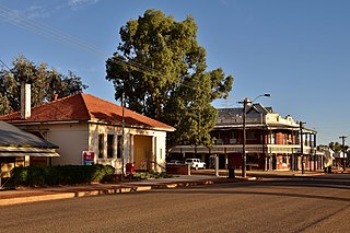
Mandiga is a town in Western Australia, in the Shire of Mount Marshall. It is located between the towns of Koorda and Mukinbudin in the Wheatbelt region.
Western Australia is a state occupying the entire western third of Australia. It is bounded by the Indian Ocean to the north and west, and the Southern Ocean to the south, the Northern Territory to the north-east, and South Australia to the south-east. Western Australia is Australia's largest state, with a total land area of 2,529,875 square kilometres, and the second-largest country subdivision in the world, surpassed only by Russia's Sakha Republic. The state has about 2.6 million inhabitants – around 11 percent of the national total – of whom the vast majority live in the south-west corner, 79 per cent of the population living in the Perth area, leaving the remainder of the state sparsely populated.
The Shire of Mount Marshall is a local government area in the Wheatbelt region of Western Australia, about 80 kilometres (50 mi) north-northwest of Merredin and about 300 kilometres (186 mi) northeast of the state capital, Perth. The Shire covers an area of 10,190 square kilometres (3,934 sq mi), and its seat of government is the town of Bencubbin.
Koorda is a town in the North Eastern Wheatbelt region of Western Australia, approximately 236 kilometres (147 mi) east of Perth and 43 kilometres (27 mi) north of Wyalkatchem at the northeastern end of the Cowcowing Lakes. It is the main town in the Shire of Koorda. At the 2006 census, Koorda had a population of 260.
Originating as a railway siding on the Wyalkatchem to Mount Marshall railway line which was opened in 1917. A town had been considered in the area in 1916 when the railway was planned. The town was gazetted in 1919, [1] but little development ever took place in the town.
Wyalkatchem townsite is located in the central agricultural region, 192 kilometres (119 mi) east-north-east of Perth and 35 kilometres (22 mi) east of Dowerin. At the 2006 census, Wyalkatchem had a population of 344.
The name is Aboriginal in origin and came from a list supplied by the surveyor Frederick Brockman who, in turn, got the names from an indigenous person in Margaret River. The name is thought to mean young girl and is correctly spelt as Mandigga.
Frederick Slade Drake-Brockman, also known as Frederick Slade Brockman, was a Surveyor General and explorer of Western Australia.
Margaret River is a town in the South West of Western Australia, located in the valley of the eponymous Margaret River, 277 kilometres (172 mi) south of Perth, the state capital. Its Local Government Area is the Shire of Augusta-Margaret River.
Mount Morgan is a town and locality in Rockhampton Region, Queensland, Australia. The town was the administrative centre of the Mount Morgan Shire until March 2008, when it was amalgamated with neighbouring local government areas to form the Rockhampton Region. In the 2011 census, Mount Morgan had a population of 2,115 people.
Zeehan is a town on the west coast of Tasmania, Australia 139 kilometres (86 mi) south-west of Burnie. It is located north of Strahan, Tasmania and Queenstown, Tasmania.
The Wheatbelt is one of nine regions of Western Australia defined as administrative areas for the state's regional development, and a vernacular term for the area converted to agriculture during colonisation. It partially surrounds the Perth metropolitan area, extending north from Perth to the Mid West region, and east to the Goldfields-Esperance region. It is bordered to the south by the South West and Great Southern regions, and to the west by the Indian Ocean, the Perth metropolitan area, and the Peel region. Altogether, it has an area of 154,862 square kilometres (59,793 sq mi).
Cranbrook is a small town in the Great Southern region of Western Australia between Katanning, Kojonup and Mount Barker, situated 320 km south of Perth. It is billed as "The Gateway to the Stirlings", referring to the nearby Stirling Range National Park. At the 2006 census, Cranbrook had a population of 280.
Mount Victoria is a small township in the Blue Mountains of New South Wales, Australia. It is the westernmost village in the City of Blue Mountains, located about 120 kilometres (75 mi) by road from the Sydney central business district and at an altitude of about 1,052 metres (3,451 ft) AHD . The settlement had a population of 823 people at the 2011 Census.
Yellowdine is a town located 402 kilometres (250 mi) east of Perth, Western Australia on the Great Eastern Highway. The townsite is in the Goldfields-Esperance region, situated in the Shire of Yilgarn.
Bakers Hill is a town 73 kilometres (45 mi) east of Perth, Western Australia on the Great Eastern Highway. The town is located within the Shire of Northam, between Wundowie and Clackline. At the 2016 census, Bakers Hill had a population of 722.
Mukinbudin is a small town in the North Eastern Wheatbelt region of Western Australia, approximately 298 kilometres (185 mi) east of Perth and 80 kilometres (50 mi) north of Merredin near Lake Campion. It is the main town in the Shire of Mukinbudin. At the 2006 census, Mukinbudin had a population of 281.
Bencubbin is a town in Western Australia in the North Eastern Wheatbelt, 275 km north-east of Perth. The town lies within the Shire of Mount Marshall and is home to approximately 294 people as of 2011. Surveyor General John Septimus Roe first surveyed the region in 1836 and he was followed by sandalwood cutters and stockmen, but it was not until 1908 that the first permanent settlers arrived.
Beacon is a town in Western Australia, in the Shire of Mount Marshall. It is 42 km (26 mi) north of Bencubbin and 333 km (207 mi) northeast of Perth by road.
Kweda is a small town located in the Wheatbelt region of Western Australia, about 45 kilometres (28 mi) east of the town of Brookton.
Mount Kokeby is a small town in the Wheatbelt region of Western Australia, about 12 kilometres (7 mi) south of the town of Beverley towards Brookton.
Gabbin is a small town in the Wheatbelt region of Western Australia.
Golden Ridge is an abandoned town in Western Australia located 615 kilometres (382 mi) east of Perth just off the Mount Monger Road in the Goldfields-Esperance region of Western Australia.
Eradu is a small town in Western Australia located in the Mid West region of Western Australia 34 kilometres (21 mi) east of Geraldton on the Geraldton–Mount Magnet Road.
Welbungin is a small town located just off the Koorda–Southern Cross road 287 km (178 mi) from Perth in the Wheatbelt region of Western Australia.
Nanson is a small town in the Mid West region of Western Australia, between the city of Geraldton and the town of Northampton. The town is situated on the banks of the Chapman River in the Chapman Valley. At the 2006 census, Nanson had a population of 386.