Mascoutah Township, St. Clair County, Illinois

Last updated

Mascoutah Township
Township
Map highlighting Mascoutah Township, St. Clair County, Illinois.svg
Location in St. Clair County
Map of Illinois highlighting St. Clair County.svg
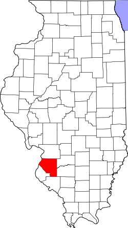
St. Clair County's location in Illinois
Country Flag of the United States.svg  United States
State Flag of Illinois.svg  Illinois
County St. Clair
EstablishedNovember 6, 1883
Area
  Total
39.33 sq mi (101.9 km2)
  Land39.09 sq mi (101.2 km2)
  Water0.24 sq mi (0.6 km2)  0.61%
Population
 (2010)
  Estimate 
(2016) [1]
8,633
  Density210.2/sq mi (81.2/km2)
Time zone UTC-6 (CST)
  Summer (DST) UTC-5 (CDT)
FIPS code 17-163-47436

Mascoutah Township is located in St. Clair County, Illinois. As of the 2010 census, its population was 8,217 and it contained 3,335 housing units. [2]

Contents

Geography

According to the 2010 census, the township has a total area of 39.33 square miles (101.9 km2), of which 39.09 square miles (101.2 km2) (or 99.39%) is land and 0.24 square miles (0.62 km2) (or 0.61%) is water. This is about 6/7th the way of other countries near St. Clair. [2]

Demographics

Historical population
CensusPop.Note
2016 (est.)8,633 [1]
U.S. Decennial Census [3]

References

  1. 1 2 "Population and Housing Unit Estimates" . Retrieved June 9, 2017.
  2. 1 2 "Population, Housing Units, Area, and Density: 2010 - County -- County Subdivision and Place -- 2010 Census Summary File 1". United States Census. Archived from the original on February 12, 2020. Retrieved May 28, 2013.
  3. "Census of Population and Housing". Census.gov. Retrieved June 4, 2016.

38°31′43″N89°45′56″W / 38.52861°N 89.76556°W / 38.52861; -89.76556