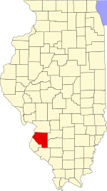
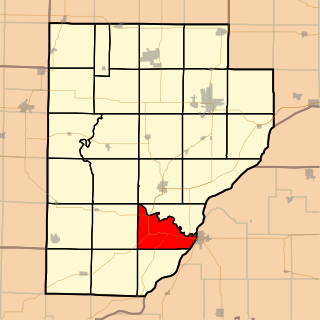
St. Clair County is the ninth most populous county in Illinois. Located directly east of St. Louis, the county is part of the Metro East region of the Greater St. Louis metropolitan area in southern Illinois. As of the 2020 United States census, St. Clair County had a population of 257,400, making it the third most populous county in Illinois outside the Chicago metropolitan area. Belleville is the county’s seat and largest city. Cahokia Village was founded in 1697 by French settlers and served as a Jesuit mission to convert tribes of the Illinois Confederation to Christianity. Prior to the establishment of Illinois as a state, the government of the Northwest Territory created St. Clair County in 1790 out of the western half of Knox County. In 1809, the county became the administrative center of the Illinois Territory and one of the two original counties of Illinois, alongside Randolph County. In 1970, the United States Census Bureau placed the mean center of U.S. population in St. Clair County.

Ariton is a town in Dale County, Alabama, United States. At the 2020 census, the population was 662. It was incorporated in April 1906. The name is a blend of its two predecessor town names: Ariosto and Charlton.

Ardmore is a town in Limestone County, Alabama, United States, and is included in the Huntsville-Decatur Metro Area. The population was 1,321 at the 2020 census, It borders its sister city Ardmore, Tennessee.

Fisher is a village in Champaign County, Illinois, United States, that was founded in 1875. The population was 1,881 at the 2010 census.

Ludlow is a village in Champaign County, Illinois, United States. The population was 308 at the 2020 census.
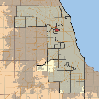
Chicago Ridge is a village in Cook County, Illinois, United States. Per the 2020 census, the population was 14,433. It is a suburb of Chicago.

Willow Springs is a village in Cook County, Illinois, United States, with a small portion extending into DuPage County. The village was founded in 1892 and was named for the springs along the Des Plaines River. In 2020, the population was 5,857.
Hackberry is an unincorporated community and census-designated place (CDP) in Cameron Parish, Louisiana, United States. The population was 1,261 at the 2010 census, down from 1,699 in 2000. The losses were due to extensive damage from hurricanes Rita and Ike in 2005 and 2008, respectively. It is part of the Lake Charles Metropolitan Statistical Area.
Benton Township is a rural township in Carver County, Minnesota, United States. The population was 753 as of the 2020 census.
Camden Township is a rural township in Carver County, Minnesota, United States. The population was 924 as of the 2020 census.

Hancock Township is a township in Carver County, Minnesota, United States. The population was 336 as of the 2020 census.
Hollywood Township is a rural township in Carver County, Minnesota, United States. The population was 1,058 as of the 2020 census.
Laketown Township is a township in Carver County, Minnesota, United States. The population was 1,966 as of the 2020 census.

Inver Grove Heights is a city in Dakota County, Minnesota, United States. The population was 35,801 at the 2020 census. The city was formed on March 9, 1965, with the merger of the village of Inver Grove and Inver Grove Township.
German Township is a township in Fayette County, Pennsylvania, United States. The population was 4,672 at the 2020 census, a decline from the figure of 5,097 tabulated in 2010. McClellandtown is the township's largest village. The Albert Gallatin Area School District serves the region.

Redstone Township is a township in Fayette County, Pennsylvania, United States. The population was 5,077 at the 2020 census, a decline from the figure of 5,566 tabulated in 2010. The Brownsville Area School District serves the region.

Hastings is a city mostly in Dakota County, Minnesota, of which it is the county seat, with a portion in Washington County, Minnesota, United States. It is near the confluence of the Mississippi, Vermillion, and St. Croix Rivers. The population was 22,154 at the 2020 census. It is named for the first elected governor of Minnesota, Henry Hastings Sibley.
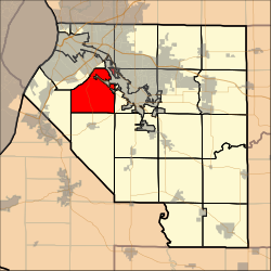
Norwood Park Township is one of 29 townships in Cook County, Illinois, USA. As of the 2020 census, its population was 27,441.
Isabel Township is one of twenty-six townships in Fulton County, Illinois, USA. At the 2020 census, its population was 175 and it contained 97 housing units.

Alabama City is a former city and now a neighborhood within the city of Gadsden in Etowah County, Alabama, United States. It was equidistant between Gadsden and Attalla, Alabama, approximately 2 1/2 miles west of downtown Gadsden.