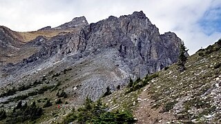
Mount Assiniboine, also known as Assiniboine Mountain, is a pyramidal peak mountain on the Great Divide, on the British Columbia/Alberta border in Canada.

Mount Columbia is a mountain located in the Winston Churchill Range of the Rocky Mountains. It is the highest point in Alberta, Canada, and is second only to Mount Robson for height and topographical prominence in the Canadian Rockies. It is located on the border between Alberta and British Columbia on the northern edge of the Columbia Icefield. Its highest point, however, lies within Jasper National Park in Alberta.

Mount Alberta is a mountain located in the upper Athabasca River Valley of Jasper National Park, Alberta, Canada. J. Norman Collie named the mountain in 1898 after Princess Louise Caroline Alberta. It is the most difficult of the 11,000ers from a climbing point of view.

Mount Edith Cavell is a mountain in the Athabasca River and Astoria River valleys of Jasper National Park, and the most prominent peak entirely within Alberta.

Mount Temple is a mountain in Banff National Park of the Canadian Rockies of Alberta, Canada.

Mount Brazeau is a mountain in Alberta, Canada.

Mount Cory is a mountain located in the Bow River Valley in southeast Banff National Park, just north of Banff, Alberta, Canada. The mountain was named in 1923 after William Wallace Cory, deputy minister of the Interior from 1905 to 1930.

The Blue Range is a mountain range of the Canadian Rockies, located on the Continental Divide in Banff National Park, Canada. The range was so named on account of its blueish colour when viewed from afar. Mount Alcantara is the highest point in the range.

Mount Saskatchewan is a mountain located in the North Saskatchewan River valley of Banff National Park, in the Canadian Rockies of Alberta, Canada.

Mount Hector is a 3,394-metre (11,135-foot) mountain summit located in the Bow River valley of Banff National Park, in the Canadian Rockies of Alberta, Canada. The mountain was named in 1884 by George M. Dawson after James Hector, a geologist on the Palliser expedition. The mountain is located beside the Icefields Parkway, 17 km (11 mi) north of Lake Louise.

Abbot Pass lies between Mount Lefroy and Mount Victoria, in the divide between the valleys of Lake O'Hara and Lake Louise. It was named for Philip Stanley Abbot who died in 1896 in an attempt to climb Mount Lefroy with Charles Fay, Charles Thompson, and George T. Little.

Abraham Lake, also known as Lake Abraham, is an artificial lake and Alberta's largest reservoir. It is located in the "Kootenay Plains area of the Canadian Rockies' front range", on the North Saskatchewan River in western Alberta, Canada.

Mount Sir Sandford is the highest mountain of the Sir Sandford Range and the highest mountain in the Selkirk Mountains of southeastern British Columbia, Canada. It is the 12th highest peak in the province. The mountain was named after Sir Sandford Fleming, a railway engineer for the Canadian Pacific Railway.
Jack William Ady was a provincial-level politician from Alberta, Canada. He served as a member of the Legislative Assembly of Alberta from 1986 to 1997. He was born in Cardston, Alberta.

Highwood Pass is a mountain pass in Kananaskis Country, Alberta, Canada. It lies west of Mount Rae and Mount Arethusa of the Misty Range, south of Elbow Pass. It lies within the Peter Lougheed Provincial Park on Alberta Highway 40. The Highwood River originates in the pass.
Mount Ulysses, is the highest mountain in the Muskwa Ranges of the Northern Canadian Rockies in British Columbia. It and neighbouring peaks are part of a group of names drawing on the epic poem The Odyssey, in which here Ulysses wanders for 10 years before being able to return home to Ithaca.

Mount Pilkington is located on the border of Alberta and British Columbia, between Mount Freshfield and Waitabit Peak. It was named in 1898 after Charles Pilkington. Mount Pilkington is located on the Continental Divide between the Campbell Icefield and the Freshfield Icefield.

The Mount Royal Cougars are the men's and women's athletic teams that represent Mount Royal University in Calgary, Alberta, Canada. The Cougars field eight varsity teams with four men's teams and four women's teams that compete in the Canada West Universities Athletic Association of U Sports. The Cougars were previously members of the Alberta Colleges Athletics Conference of the Canadian Colleges Athletic Association prior to the move to CIS in 2012.

Mount Byng is a 2,965-metre (9,728-foot) mountain summit located in the upper Spray River Valley of southern Banff National Park, in the Canadian Rockies of Alberta, Canada. It is the second-highest point in the Blue Range. Mount Byng's nearest higher peak is Mount Alcantara, 6.5 km (4.0 mi) to the west-southwest. The mighty Mount Assiniboine is situated 10.0 km (6.2 mi) to the northwest of Byng.
Mount Currie is a 2,770-metre (9,090-foot) mountain summit located in the upper Spray River Valley of southern Banff National Park, in the Canadian Rockies of Alberta, Canada. Mount Currie's nearest higher peak is Red Man Mountain, 3.3 km (2.1 mi) to the southwest on the Continental Divide.


