
Sierra Leone is a country in West Africa with a North Atlantic Ocean coastline to the west. It lies on the African Plate. The country's main geographical features include wooded hill country, an upland plateau, and mountains in the east. The highest peak is Mount Bintumani, which is 1,948 meters (6,391 ft) above sea level. The coastline has a belt of mangrove swamps. Freetown, the nation's capital city, has one of the world's largest natural harbours. The Rokel River is the largest river in Sierra Leone. It is 400 kilometres (250 mi) long and has a basin with a total area of 10,622 square kilometres (4,101 sq mi).
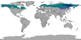
The subarctic climate is a continental climate with long, cold winters, and short, warm to cool summers. It is found on large landmasses, often away from the moderating effects of an ocean, generally at latitudes from 50°N to 70°N, poleward of the humid continental climates. Like other Class D climates, they are rare in the Southern Hemisphere, only found at some isolated highland elevations. Subarctic or boreal climates are the source regions for the cold air that affects temperate latitudes to the south in winter. These climates represent Köppen climate classification Dfc, Dwc, Dsc, Dfd, Dwd and Dsd.

Stowe is a town in Lamoille County, Vermont, United States. The population was 5,223 at the 2020 census. The town lies on Vermont Routes 108 and 100. It is nicknamed "The Ski Capital of the East" and is home to Stowe Mountain Resort, a ski facility with terrain on Mount Mansfield, the highest peak in Vermont, and Spruce Peak.

Yoho National Park is a national park of Canada. It is located within the Rocky Mountains along the western slope of the Continental Divide of the Americas in southeastern British Columbia, bordered by Kootenay National Park to the south and Banff National Park to the east in Alberta. The word Yoho is a Cree expression of amazement or awe, and it is an apt description for the park's spectacular landscape of massive ice fields and mountain peaks, which rank among the highest in the Canadian Rockies.

Continental climates often have a significant annual variation in temperature. They tend to occur in central and eastern parts of the three northern-tier continents, typically in the middle latitudes, often within large landmasses, where prevailing winds blow overland bringing some precipitation, and temperatures are not moderated by oceans. Continental climates occur mostly in the Northern Hemisphere due to the large landmasses found there. Most of northeastern China, eastern and southeastern Europe, much of Russia south of the Arctic Circle, central and southeastern Canada, and the central and northeastern United States have this type of climate. Continentality is a measure of the degree to which a region experiences this type of climate.

Mount Columbia is a mountain located in the Winston Churchill Range of the Rocky Mountains. It is the highest point in Alberta, Canada, and is second only to Mount Robson for height and topographical prominence in the Canadian Rockies. It is located on the border between Alberta and British Columbia on the northern edge of the Columbia Icefield. Its highest point, however, lies within Jasper National Park in Alberta.
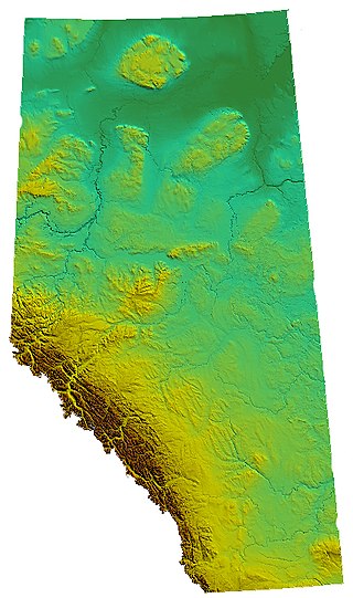
Alberta is one of the thirteen provinces and territories of Canada. Located in Western Canada, the province has an area of 661,190 km2 (255,290 sq mi) and is bounded to the south by the United States state of Montana along 49° north for 298 km (185 mi); to the east at 110° west by the province of Saskatchewan for 1,223 km (760 mi); and at 60° north the Northwest Territories for 644 km (400 mi). The southern half of the province borders British Columbia along the Continental Divide of the Americas on the peaks of the Rocky Mountains, while the northern half borders British Columbia along the 120th meridian west. Along with Saskatchewan it is one of only two landlocked provinces or territories.
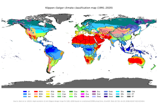
The Köppen climate classification divides climates into five main climate groups, with each group being divided based on patterns of seasonal precipitation and temperature. The five main groups are A (tropical), B (arid), C (temperate), D (continental), and E (polar). Each group and subgroup is represented by a letter. All climates are assigned a main group. All climates except for those in the E group are assigned a seasonal precipitation subgroup. For example, Af indicates a tropical rainforest climate. The system assigns a temperature subgroup for all groups other than those in the A group, indicated by the third letter for climates in B, C, D, and the second letter for climates in E. For example, Cfb indicates an oceanic climate with warm summers as indicated by the ending b. Climates are classified based on specific criteria unique to each climate type.

An oceanic climate, also known as a marine climate or maritime climate, is the temperate climate sub-type in Köppen classification represented as Cfb, typical of west coasts in higher middle latitudes of continents, generally featuring cool to warm summers and cool to mild winters, with a relatively narrow annual temperature range and few extremes of temperature. Oceanic climates can be found in both hemispheres generally between 40 and 60 degrees latitude, with subpolar versions extending to 70 degrees latitude in some coastal areas. Other varieties of climates usually classified together with these include subtropical highland climates, represented as Cwb or Cfb, and subpolar oceanic or cold subtropical highland climates, represented as Cfc or Cwc. Subtropical highland climates occur in some mountainous parts of the subtropics or tropics, some of which have monsoon influence, while their cold variants and subpolar oceanic climates occur near polar or tundra regions.

A humid continental climate is a climatic region defined by Russo-German climatologist Wladimir Köppen in 1900, typified by four distinct seasons and large seasonal temperature differences, with warm to hot summers, and cold and snowy winters. Precipitation is usually distributed throughout the year, but often these regions do have dry seasons. The definition of this climate in terms of temperature is as follows: the mean temperature of the coldest month must be below 0 °C (32.0 °F) or −3 °C (26.6 °F) depending on the isotherm, and there must be at least four months whose mean temperatures are at or above 10 °C (50 °F). In addition, the location in question must not be semi-arid or arid. The cooler Dfb, Dwb, and Dsb subtypes are also known as hemiboreal climates. Although amount of snowfall is not a factor used in defining the humid continental climate, snow during the winter in this type of climate is almost a guarantee, either intermittently throughout the winter months near the poleward or coastal margins, or persistently throughout the winter months elsewhere in the climate zone.

Mount Davis is the highest point in Pennsylvania. Located in Forbes State Forest near the hamlet of Markleton in Elk Lick Township, Somerset County, it lies on a gentle crest of a 30-mile (50 km) ridge extending from central Somerset County southward into Garrett County, Maryland, where it is known as Negro Mountain. A parcel of land on top of the mountain has been protected as Mount Davis Natural Area.

Carter Dome, or simply The Dome, is a mountain located in Coös County, New Hampshire, U.S. It has a maximum elevation of 4,826 feet (1,471 m), placing it on the list of the state's four-thousand footers.
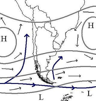
The climate of Chile comprises a wide range of weather conditions across a large geographic scale, extending across 38 degrees in latitude, making generalizations difficult. According to the Köppen system, Chile within its borders hosts at least seven major climatic subtypes, ranging from low desert in the north, to alpine tundra and glaciers in the east and southeast, tropical rainforest in Easter Island, Oceanic in the south and Mediterranean climate in central Chile. There are four seasons in most of the country: summer, autumn, winter, and spring.
Montreal is the second largest city in Canada and the largest city in the province of Quebec, located along the Saint Lawrence River at its junction with the Ottawa River. The city is geographically constrained, with the majority on the Island of Montreal in the Hochelaga Archipelago, and has several prominent features, including the eponymous Mount Royal. The region experiences four distinct seasons and is classified as a humid continental climate, with very cold and snowy winters and warm and humid summers.

Parapet Peak is located at southern end of Mount Robson Provincial Park on the border of Alberta and British Columbia. It was named in 1921 by Cyril G. Wates.

Mount Rhondda is located on the Continental Divide straddling the Canadian provinces of Alberta and British Columbia. It was named in 1917 by the Interprovincial Boundary Survey after David Alfred Thomas, First Viscount Baron Rhondda.

Mount Beatty is a mountain located on the border of Alberta and British Columbia on the Continental Divide. It was named in 1924 after David Beatty, a British naval officer of Irish ancestry who commanded ships in the First World War.

Mount Foch is a 3,194-metre (10,479-foot) mountain summit located on the border of Alberta and British Columbia on the Continental Divide. It was named in 1918 after Marshal Ferdinand Foch.

Mount Fox is a 2,973-metre (9,754-foot) mountain on the shared border between Alberta and British Columbia, Canada. It is situated on the Continental Divide south of the Kananaskis Lakes area of the Canadian Rockies. It was named in 1859 by John Palliser after Sir Charles Fox (1810-1874), a member of the Royal Geographical Society.
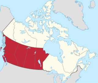
Western Canada, also referred to as the Western provinces, Canadian West, or Western provinces of Canada, and commonly known within Canada as the West, is a Canadian region that includes the four western provinces just north of the Canada–United States border namely British Columbia, Alberta, Saskatchewan and Manitoba. The people of the region are often referred to as "Western Canadians" or "Westerners", and though diverse from province to province are largely seen as being collectively distinct from other Canadians along cultural, linguistic, socioeconomic, geographic and political lines. They account for approximately 32% of Canada's total population.


