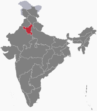
Haryana is an Indian state located in the northern part of the country. It was carved out after the linguistic reorganisation of Punjab on 1 November 1966. It is ranked 21st in terms of area, with less than 1.4% of India's land area. The state capital is Chandigarh, which it shares with the neighbouring state of Punjab; and the most populous city is Faridabad, a part of the National Capital Region. The city of Gurgaon is among India's largest financial and technology hubs. Haryana has 6 administrative divisions, 22 districts, 72 sub-divisions, 93 revenue tehsils, 50 sub-tehsils, 140 community development blocks, 154 cities and towns, 7,356 villages, and 6,222 villages panchayats.

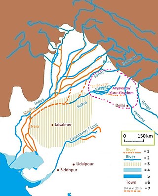
Doab is a term used in South Asia for the tract of land lying between two confluent rivers. It is similar to an interfluve. In the Oxford Hindi-English Dictionary, R. S. McGregor defines it as from Persian do-āb "a region lying between and reaching to the confluence of two rivers."

Yamunanagar, is a city and a municipal corporation in Yamunanagar district in the Indian state of Haryana. This town is known for the cluster of plywood units and paper factories. It provides timber to larger industries. The older town is called Jagadhri. The Yamunanagar-Jagadhri railway station (YJUD) services the city. Despite its name, Jagadhri Railway is situated in Yamunanagar. There is also another railway station called Jagadhri Workshop in Yamunanagar.

Hisar district is one of the 22 districts of Haryana, India. Hisar city serves as the district headquarters. Hisar district has four sub-divisions that is, Hisar, Barwala, Hansi and Narnaud, each headed by an SDM. The district is also part of Hisar division. Hisar was founded by Firuz Shah Tughlaq.

Chak, a Punjabi word, is the land revenue settlement/assessment circle marking a contiguous block of land. The word Chak comes from Chakar referring to a wheel in Punjabi, specifically a wheel associated with a water well. Historically there was one water well allotted per village and every village number allotted as per water-well wheel. Now the individual chak circles have come to be associated with the name of the village founded within the revenue circle. Chak circles are based on the British Raj era revenue collection system. To enhance the government revenue during the British Raj, new canals were built to bring the barani (rainfed) areas under cultivation by introducing the irrigation to the bangar (upland) areas of Punjab region. Block of contiguous land irrigated by the specific Rajwaha were given a unique chak number each. The migrant farmers were brought in to settle into those newly irrigated areas around the core of new villages [which started out as dhanis]. Those new villages were called by the same name as their corresponding irrigation circle chak number. Government left it to those residents to give "chaks" a proper village name later. In due time, the term "chak" became synonymous with the term "village".

Puadh is a historic region in north India that comprises parts of present-day Punjab, Haryana, Uttar Pradesh, Himachal Pradesh and the U.T. of Chandigarh, India. It has the Sutlej river in its north and covers the regions immediately south of the Ghaggar river. The people of the area are known as Puadhi and speak the Puadhi dialect of Punjabi. The capital cities of Puadh region are Rupnagar, Fatehgarh Sahib, Mohali, Patiala, Sangrur, Mansa Chandigarh, Nalagarh, Panchkula, Baddi, Ambala, Yamunanagar.

Haryana is a state in India. The state houses several sites from the Indus Valley Civilization, which was a cradle of civilisation. In the Mahabharata, Haryana is mentioned as Bahudanayak Region.

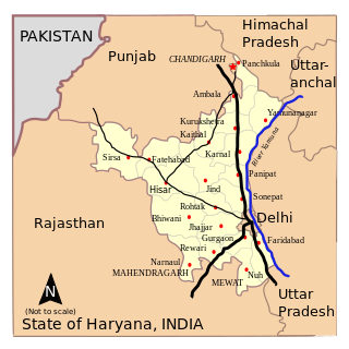
Haryana, formed on 1 November 1966, is a state in North India. For the administrative purpose, Haryana is divided into 6 revenue divisions which are further divided into 22 districts. For Law and Order maintenance, it is divided into 5 Police Ranges and 4 Police Commissionerates.

Dhani or Thok is a type of hamlet, the smallest conglomeration of houses, in the sandy Bagar region of the northwestern states of Rajasthan, Haryana and Punjab in India. Per the Census of India, 70% of Indians live in villages. 80% of the villages have a population of less than 1000 people and each consists of a cluster of hamlets. Most dhanis are nucleated settlements, while others are more dispersed. A dhani could be as small as one isolated house for a single family or a small cluster of several houses which could grow in number with successive generations, and even become a village by itself. All families living in a dhani are relatives or at least are of the same caste. An isolated collection of several dhanis, which could be few hundred meters apart, constitutes a gram panchayat village community. A typical dhani in the arid zone of Rajasthan is a cluster of huts with a boundary made of dried shrubs around it and with owners' livestock such as goats, sheep and camels inside the bara. Dhani are atypically mud huts in Rajasthan. Houses in dani nowadays are made of modern brick and mortar, specially in affluent higher-per-capita-income states of Haryana and Punjab, and some richer families of Rajasthan.

Puadhi is an eastern dialect of the Punjabi language primarily spoken in the Puadh region of northern India. It is spoken between the Sutlej and Ghaggar river basins in the present day states of Punjab and Haryana, and the union territory of Chandigarh and Uttar Pradesh.

Khādir or Khadar and Bangar, Bāngur or Bhangar are terms used in Hindi, Urdu, Punjabi and Sindhi in the Indo-Gangetic plains of North India and Pakistan to differentiate between two types of river plains and alluvial soils. Bangur and Khadir areas are commonly found in the doab regions. Some villages may have both Khadar and Bangar areas within their revenue boundaries. Bhangar soils are less fertile as they are above flood level whereas Khadar soils are more fertile as they are below the flood level. Bhanger is full of kankers while khadar soil is composed of fine silt and clay. It is fertile land as it contains alluvial soil deposited by rivers.
The following outline is provided as an overview of and topical guide to Haryana.
Elections in Haryana, which is a state in India, have been conducted since 1967 to elect the members of state-level Haryana Legislative Assembly and national-level Lok Sabha. There are 90 assembly constituencies and 10 Lok Sabha constituencies.

Bagar, also Bagad (बागड़) a term meaning the "dry country", is a region refers in north-western India in north Rajasthan, West Haryana, south west Punjab, India where the Bagri language is spoken and which is inhabited by Bagri people. The region is characterised by sandy tracks and shifting sand dunes which are now irrigated by canals.
Western Yamuna Canal is canal in river Yamuna that was dug out and renovated in 1335 CE by Firoz Shah Tughlaq. In 1750 CE, excessive silting caused it to stop flowing. The British raj undertook a three-year renovation in 1817 by Captain GR Blane of the Bengal Engineer Group. In 1832-33 Tajewala Barrage dam at Yamunanagar was also built to regulate the flow of water, and later Pathrala barrage at Dadupur,Yamuna Nagar and Somb river dam downstream of canal were constructed in 1875-76. In 1889-95 the largest branch of the canal Sirsa branch was constructed. The modern Hathni Kund Barrage was built in 1999 to handle the problem of silting to replace the older Tajewala Barrage.

The Kaushalya river, a tributary of Ghaggar river, is a river in Panchkula district of Haryana state of India.
The Tangri River, also called the Dangri River, which originates in the Shivalik Hills, is a tributary of the Ghaggar River in the Haryana state of India.

The Markanda is a river in the Indian states of Himachal Pradesh and Haryana. It is a tributary of the Ghaggar river, flowing through Sirmaur District, Ambala district and Shahabad Markanda, a town in Kurukshetra district. The Markanda river's ancient name was Aruna.
The Somb river, also spelled Som river is a tributary of Yamuna in Haryana state of India.
Pathrala Barrage is a barrage across the Somb river, located in Yamuna Nagar District, in the state of Haryana, India.