Peda Waltair

Last updated

Peda Waltair/Pedda Waltair
Neighbourhood
Karaka Chettu Polamamba Temple.JPG
Karaka Chettu Polamamba Temple at Peda Waltair
Visakhapatnam City Area Map.png
Red pog.svg
Peda Waltair/Pedda Waltair
Location in Visakhapatnam
Coordinates: 17°43′59″N83°19′56″E / 17.732943°N 83.332220°E / 17.732943; 83.332220
CountryFlag of India.svg  India
State Andhra Pradesh
District Visakhapatnam
Government
  Body Greater Visakhapatnam Municipal Corporation
Languages
  Official Telugu
Time zone UTC+5:30 (IST)
PIN
530017
Vehicle registration AP 31,AP 32 and AP 33

Peda Waltair/Pedda Waltair is a residential locality situated at the eastern part of Visakhapatnam, India. [1]

Contents

Karakachettu Road at Pedawaltair. Karachettu Road in Visakhaptnam.jpg
Karakachettu Road at Pedawaltair.

Etymology

The name Waltair/Valteru(వాల్తేరు) is derived from two words Valu (meaning sloping) and Yeru/Eru (meaning river), [2] it is often incorrectly attributed to the name of a British officer who worked as a collector in Visakhapatnam in the 18th century. However, a look into the records of Vizagapatam(Visakhapatnam) since its inception as a District (1802-03) has proven that not even one District named 'Walter' had ever been posted here. [3]

History

The village of Valteru has often found its name used synonymously with Vizagapatam even until a few decades ago. The Visakhapatnam railway station was also called as Waltair railway station. The village of Waltair finds itself in the annals of history as an important center which attracted the interest of a lot of Europeans. Adjacent to this village sits the picturesque beaches of Lawsons Bay Colony. The name of this estate originated from the Britisher commander of an Indiaman ship "Lord Hobart" who owned this cove up until his demise in late 1820. [4] The villages 'Pedda Waltair' and 'Chinna Waltair' were probably just called Valteru before the Dutch and English came here and made it their home. It is believed that the part of the village on one side of the river is named as 'Pedda Waltair' due to its bigger area, while the other side was named 'Chinna Waltair'. Mentions of Waltair were also available in the Vizagapatam district Gazzeteer of 1907. [5]

Culture

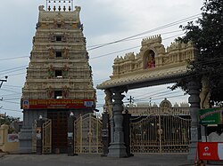
The most famous place of worship here is Sri Karakachettu Polamamba Temple. This deity (grama devata, గ్రామదేవత/village deity) is considered as the protector of 14 villages (including Valteru/Waltair) around Waltair. Every year, the first Sunday after the Telugu new year (Ugadi) a proclamation (చాటింపు) is made in these 14 villages that 9 days following that Sunday i.e., Tuesday (usually in March/April) all these villages will celebrate in honour of the beloved goddess. This celebration is said be have been happening from the 15th century. The presiding deity in the temple is said to be found by the fishermen from the neighbouring village 'Jalaripeta', who then handed over the deity to the local Reddys/Reddis as per the wish of the goddess who appeared in the dreams of those fishermen. Since then, the goddess was placed under a sacred sage-leaved Gall Nut tree (Karakachettu) and celebrated every year thanking her for the prosperity and safety provided by her.

See also

Related Research Articles

<span class="mw-page-title-main">Visakhapatnam</span> Metropolis in Andhra Pradesh, India

Visakhapatnam, also known as Vizag, Viśākha or Waltair, is the largest and most populous metropolitan city in the Indian state of Andhra Pradesh. It is between the Eastern Ghats and the coast of the Bay of Bengal. It is the second largest city on the east coast of India after Chennai, and the fourth-largest in South India. It is one of the four smart cities of Andhra Pradesh selected under the Smart Cities Mission and is the headquarters of Visakhapatnam district. With an estimated output of $43.5 billion, it is the ninth-largest contributor to India's gross domestic product as of 2016.

<span class="mw-page-title-main">Mariamman</span> Hindu goddess of weather

Mariamman, often abbreviated to Amman, is a Hindu goddess of weather, predominantly venerated in the rural areas of South India. Her festivals are held during the late summer/early autumn season of Ādi throughout Tamil Nadu and the Deccan region, the largest being the Ādi Thiruviḻa. Her worship mainly focuses on bringing rains and curing diseases like cholera, smallpox, and chicken pox. Mariamman is worshipped in accordance with local traditions such as Pidari or the Gramadevatai. She is considered as a guardian deity by many South Indian village-dwellers.

<span class="mw-page-title-main">Madras Presidency</span> Administrative subdivision of India through 1950

The Madras Presidency or Madras Province, officially called the Presidency of Fort St. George until 1937, was an administrative subdivision (province) of British India and later the Dominion of India. At its greatest extent, the presidency included most of southern India, including all of present-day Andhra Pradesh, almost all of Tamil Nadu and parts of Kerala, Karnataka, Odisha and Telangana in the modern day. The city of Madras was the winter capital of the presidency and Ooty was the summer capital.

<span class="mw-page-title-main">Koraput district</span> District of Odisha in India

Koraput district is a district of India in southern Odisha, with headquarters at Koraput. The district is located in the Eastern Ghats and is known for its hilly terrain, rich and diverse types of mineral deposits and its tribal culture and traditions. The district headquarters town of Koraput and its largest city, Jeypore are major centres of trade and commerce for South Odisha and fall on an important road connecting Visakhapatnam to Raipur.

<span class="mw-page-title-main">Visakhapatnam district</span> District in Andhra Pradesh, India

Visakhapatnam district is one of the six districts in the Uttarandhra region of the Indian state of Andhra Pradesh, headquartered at Visakhapatnam. It is one of the twenty-six districts in Andhra Pradesh state. The district shares borders within the north and east, Vizianagaram district and South Anakapalli district in the south-west and Bay of Bengal in the south.

<span class="mw-page-title-main">Allur, Nellore district</span> Town in Andhra Pradesh, India

Allur is a Town in Nellore district of the Indian state of Andhra Pradesh. It is the headquarters of Allur Mandal of Kavali revenue division.

<span class="mw-page-title-main">Shamshabad</span> Town in Telangana, India

Shamshabad is a census town in the Indian state of Telangana. It is located in Shamshabad mandal of Rajendranagar revenue division. Sri Vendikonda Siddalingeshwara Devastanam temple is situated in Siddulagutta Road in Shamshabad mandal. The international airport of Hyderabad is located here.

<span class="mw-page-title-main">Sheik Chinna Moulana</span> Indian nagaswaram musician (1924–1999)

Sheik Chinna Moulana, popularly known as Sheik, was a legendary nadhaswaram player in the Carnatic tradition. He was awarded the Madras Music Academy's Sangeetha Kalanidhi in 1998. He achieved high position through his outstanding control over the instrument, rendering the Krities in the Gayaki style and for his extraordinary style of Raga Alapana.

<span class="mw-page-title-main">North Andhra</span> Geographic region of Andhra Pradesh in India

North Andhra or Uttara Andhra, also known as Kalinga Andhra, is a geographic region in the Indian state of Andhra Pradesh. It is between the Eastern Ghats and the coast of the Bay of Bengal. It comprises six northern districts of the state, Srikakulam, Parvathipuram Manyam, Vizianagaram, Visakhapatnam, Alluri Sitharama Raju and Anakapalli. As of 2011 census of India, the region with six districts has a population of 9,338,177.

<span class="mw-page-title-main">Mariyamma Temple</span> Hindu temple in Karnataka, India

The Mariyamma Temple is situated in Boloor, India, dedicated to Goddess Mariyamma, situated approximately 5 km from Mangaladevi Temple in Mangalore city, Karnataka, India. It is believed that Mariyamma and Mangaladevi were sisters.

Vamanapuram is a village in Thiruvananthapuram district in the state of Kerala, India. It is the location of Shri 'Vamana', one of the ten incarnations of Maha Vishnu. The Lord Vamana temple is located here, and hence the name Vamanapuram, meaning 'the city of the lord Vamana'.

Chandole is a village in Bapatla district of the Indian state of Andhra Pradesh. It is located in Pittalavanipalem mandal of Bapatla revenue division.

Sri Thanthondreeswarar Temple or Sri Thanthondrieswarar Temple is at Belur in the Indian state of Tamil Nadu.

Komuravelli Mallikarjuna Swamy Temple popularly known as Komrelly Mallanna Temple is a Hindu temple located on a hill in Komuravelli village of Siddipet district in Telangana state, India. It is located near Siddipet on SH–1 Rajiv Rahadari. The primary deity is Mallanna or Mallikarjuna Swamy, a form of Shiva. The deity is also called as Khandoba by the Maharashtrian people. The temple is located about 85 kilometers from Hyderabad. In the year 2024, an infrastructure push by the state government laid the Foundation stone for the Komuravelli railway station to ensure easy access to the temple. The station is part of the Kothapalli–Manoharabad line.

<span class="mw-page-title-main">Pedda Korpole</span> Village in Telangana, India

Pedda Korpole is a village located in Nekkonda of Warangal district in Telangana state, India. It is located very near to the Kazipet Vijayawada railway line. It comes under Narsampet, Mahabubabad and Mahabubabad Revenue Division. Village has huge population whose main occupation is agriculture. This Village produces Turmeric root, Cotton, Paddy, Maize and all types of Vegetables.

The Bobbili Fort, located in the Vizianagaram district of the Indian state of Andhra Pradesh, was built during the middle of the 19th century in Bobbili. It has a historical link to the nearby mud fort of the same name which was destroyed during the Bobbili war in 1757 in a feud between the Rajas of Bobbili and the neighbouring Maharaja of Vizianagaram.

<span class="mw-page-title-main">History of Visakhapatnam</span>

Visakhapatnam is a major metropolitan city in the state of Andhra Pradesh, and it holds the distinction of being the largest city in the state. The rich history of Visakhapatnam dates back over 2,500 years, with its present name potentially given by the Eastern Chalukyas king to their family deity Visakha in 1010 CE. Visakhapatnam, steeped in a history that spans millennia, was once part of the Kalinga Kingdom around 260 BC before coming under the influence of the Maurya Empire. During this period, Buddhism flourished, leading to the construction of significant monuments between the 2nd century BCE and the 2nd century CE. The city's documented existence begins in 1068 CE, under the rule of King Vishakhavarman. In the 7th century, Visakhapatnam witnessed the conquest of the Eastern Chalukyas, and by the 14th century, it became part of the Reddi Kingdom. The era of European colonization commenced in 1630 with the Dutch, followed by the British taking control in 1757 after a brief interlude of French influence. The Battle of Vizagapatam in 1804 during the Napoleonic Wars emphasized the strategic importance of the city. Following India's independence in 1947, Visakhapatnam became part of the Madras Presidency, later becoming an integral part of Andhra Pradesh. Today, it stands as the largest city in Andhra Pradesh, playing a pivotal role in the state's economy. The city's industrial growth saw a transformative phase with the inauguration of Visakhapatnam Port operations on December 19, 1933, firmly establishing it as a major industrial centre.

The Vizagapatam Hill Tracts Agency was an agency in the Madras Presidency of British India. The agency was autonomous and supervised by an agent subordinate to the District Collector of Vizagapatam District.

Bobbili Estate was a Zamindari in the Vizagapatam District of the Madras Presidency, presently in the Vizianagaram district, Andhra Pradesh, India. It comprises 153 Jeroyati villages, 53 Agraharams, 5 Mokhasas by 1907 and a revenue of 8,33,000/- by 1938. It is one of the most influential Zamindari. It is spread over 300 square miles. It also bought shares in many estates like Kirlampudi, Dontamuru etc. It prospered in the period of British Raj.

<span class="mw-page-title-main">Polavaram Estate</span>

Polavaram Estate is one the Zamindari estates in Godavari district under the jurisdiction of Madras Presidency. In 1905, The Estate was part of the Pólavaram division is the south-westernmost portion of the Gódávari Agency, and lies on the right bank of the river. At the permanent settlement of 1802-03 the entire division was all included in the Pólavaram estate. Only 24 of its villages are zamindari land, of which twelve belong to the so-called Pólavaram and Pattisam estates; five belong to the Gútála estate and four to the estate of Gangólu; and one village belongs to each of the muttas of Bayyanagúdem, Billumilli and Jangareddigúdem, which three form one estate.

References

  1. Sarma, G. v Prasada (15 September 2018). "24x7 water supply scheme to cover 10,000 households". The Hindu. ISSN   0971-751X . Retrieved 3 May 2019.
  2. Manual Of The Administration - Madras Presidency Volume 3, 1893, pp 1020.
  3. https://visakhapatnam.ap.gov.in/history-of-collectors/
  4. A Manual of the District of Vizagapatam in the Presidency of Madras. Madras, 1869.
  5. Madras District Gazetteers-Vizagapatam, 1907.