Phillips, Wisconsin | |
---|---|
Coordinates: 45°41′30″N90°24′7″W / 45.69167°N 90.40194°W | |
Country | United States |
State | Wisconsin |
County | Price |
Area | |
• Total | 3.34 sq mi (8.64 km2) |
• Land | 2.63 sq mi (6.81 km2) |
• Water | 0.71 sq mi (1.84 km2) |
Elevation | 1,444 ft (440 m) |
Population | |
• Total | 1,533 |
• Density | 460/sq mi (180/km2) |
Time zone | UTC-6 (Central (CST)) |
• Summer (DST) | UTC-5 (CDT) |
Zip Code | 54555 |
Area code(s) | 715 & 534 |
FIPS code | 55-62450 [4] |
GNIS feature ID | 1571294 [2] |
Website | cityofphillips |
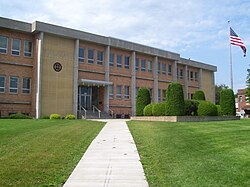
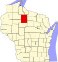
Phillips is a city and the county seat of Price County, Wisconsin, United States. The population was 1,533 at the 2020 census.
The town of Phillips was platted in 1876 and named after Elijah B. Phillips, the general manager of the Wisconsin Central Railway. It began as a logging town. [5]
In the dry summer of 1894, a devastating fire spread from the southwest and destroyed the town. The population evacuated, and 13 people died in the blaze. [6] [7] The town was rebuilt and expanded in subsequent years, and a memorial to the disaster now stands on the shore of Lake Duroy. [8]
Phillips is located at 45°41′30″N90°24′7″W / 45.69167°N 90.40194°W (45.691560, -90.401915). [9] It is on highway SR 13, 77 miles north of Marshfield, and 74 miles south of Ashland.
According to the United States Census Bureau, the city has a total area of 3.51 square miles (9.09 km2), of which, 2.79 square miles (7.23 km2) is land and 0.72 square miles (1.86 km2) is water. [10]
Census | Pop. | Note | %± |
---|---|---|---|
1900 | 1,820 | — | |
1910 | 1,948 | 7.0% | |
1920 | 1,973 | 1.3% | |
1930 | 1,901 | −3.6% | |
1940 | 1,915 | 0.7% | |
1950 | 1,775 | −7.3% | |
1960 | 1,524 | −14.1% | |
1970 | 1,511 | −0.9% | |
1980 | 1,522 | 0.7% | |
1990 | 1,592 | 4.6% | |
2000 | 1,675 | 5.2% | |
2010 | 1,478 | −11.8% | |
2020 | 1,533 | 3.7% | |
U.S. Decennial Census [11] |
As of the census [12] of 2010, there were 1,478 people, 695 households, and 338 families living in the city. The population density was 529.7 inhabitants per square mile (204.5/km2). There were 868 housing units at an average density of 311.1 per square mile (120.1/km2). The racial makeup of the city was 95.1% White, 0.7% African American, 0.7% Native American, 1.4% Asian, 0.1% Pacific Islander, 0.1% from other races, and 2.0% from two or more races. Hispanic or Latino people of any race were 1.5% of the population.
There were 695 households, of which 23.9% had children under the age of 18 living with them, 34.0% were married couples living together, 11.4% had a female householder with no husband present, 3.3% had a male householder with no wife present, and 51.4% were non-families. 45.0% of all households were made up of individuals, and 24.3% had someone living alone who was 65 years of age or older. The average household size was 2.00 and the average family size was 2.79.
The median age in the city was 44.8 years. 20.2% of residents were under the age of 18; 7.4% were between the ages of 18 and 24; 22.9% were from 25 to 44; 25.9% were from 45 to 64; and 23.6% were 65 years of age or older. The gender makeup of the city was 47.6% male and 52.4% female.
As of the census [4] of 2000, there were 1,675 people, 721 households, and 395 families living in the city. The population density was 605.5 people per square mile (233.5/km2). There were 839 housing units at an average density of 303.3 per square mile (116.9/km2). The racial makeup of the city was 96.96% White, 1.19% Native American, 0.72% Asian, 0.12% from other races, and 1.01% from two or more races. Hispanic or Latino people of any race were 0.36% of the population.
There were 721 households, out of which 28.3% had children under the age of 18 living with them, 39.8% were married couples living together, 11.4% had a female householder with no husband present, and 45.1% were non-families. 39.8% of all households were made up of individuals, and 21.9% had someone living alone who was 65 years of age or older. The average household size was 2.14 and the average family size was 2.89.
In the city, the population was spread out, with 22.7% under the age of 18, 7.3% from 18 to 24, 24.1% from 25 to 44, 21.7% from 45 to 64, and 24.1% who were 65 years of age or older. The median age was 42 years. For every 100 females, there were 83.9 males. For every 100 females age 18 and over, there were 80.0 males.
The median income for a household in the city was $31,471, and the median income for a family was $38,889. Males had a median income of $32,333 versus $24,028 for females. The per capita income for the city was $16,480. About 7.2% of families and 12.5% of the population were below the poverty line, including 15.4% of those under age 18 and 21.4% of those age 65 or over.
Phillips is the county seat of Price County. The current mayor is Charles Peterson. [13]
Year | Republican | Democratic | Third parties |
---|---|---|---|
2020 | 57.1%408 | 41.0% 293 | 2.0% 14 |
2016 | 53.0%329 | 41.9% 260 | 5.1% 32 |
2012 | 42.5% 291 | 55.9%383 | 1.6% 11 |
2008 | 38.4% 266 | 60.0%416 | 1.6% 11 |
2004 | 46.1% 380 | 52.9%436 | 1.0% 8 |
2000 | 53.3%390 | 43.3% 317 | 3.4% 25 |
Phillips is served by the Price County Airport (KPBH), located one mile northwest of the city. In 2023, the airport handled approximately 18,100 operations per year, almost 50 per day, with roughly 84% general aviation, 15% air taxi and 1% military. The airport has a 5,220 foot asphalt primary runway with approved GPS approaches (Runway 1-19) and a 3,951 foot asphalt crosswind runway (Runway 6-24), also with GPS approaches. [15]
Bus service is provided by Bay Area Rural Transit.
Emerson is a city in Mills County, Iowa, United States. The population was 403 at the time of the 2020 census.
Dedham is a town in Hancock County, Maine, United States. The population was 1,648 at the 2020 census. The town includes the site of a Cold War airplane crash on Bald Mountain.
Lamar is a city in and the county seat of Barton County, Missouri, United States. As of the 2020 census, the city population was 4,266. It is known as the birthplace of Harry S. Truman, the 33rd president of the United States.
Beaver is a town in Clark County in the U.S. state of Wisconsin. The population was 885 at the 2010 census.
Poynette is a village in Columbia County, Wisconsin, United States. The population was 2,590 at the 2020 census. It is part of the Madison Metropolitan Statistical Area.
Empire is a town in Fond du Lac County, Wisconsin, United States. The population was 2,620 at the 2000 census.
Markesan is a city in Green Lake County, Wisconsin, United States. The population was 1,476 at the 2010 census. The center of population of Wisconsin is located in Markesan.
Tigerton is a village in Shawano County, Wisconsin, United States. The population was 741 at the 2010 census.
Galesville is a city in Trempealeau County, Wisconsin, United States. The population was 1,662 at the 2020 census. A dam on Beaver Creek is located at Galesville, forming Lake Marinuka north of the city. The mayor is Vince Howe.
Plymouth is a town in Sheboygan County, Wisconsin. The population was 3,115 at the time of the 2000 census. It is included in the Sheboygan, Wisconsin Metropolitan Statistical Area. The City of Plymouth is located within the town, but is politically independent. The unincorporated community of New Paris is also located in the town.
Brillion is a city in Calumet County in the U.S. state of Wisconsin. The population was 3,538 as of 2024. The city is located within the Town of Brillion, though it is politically independent.
Colby is a city in Clark and Marathon counties in the U.S. state of Wisconsin. It is part of the Wausau, Wisconsin Metropolitan Statistical Area. The population was 1,852 at the 2010 census. Of this, 1,354 were in Clark County, and 498 were in Marathon County. The city is bordered by the Town of Colby, the Town of Hull, and the City of Abbotsford. Colby cheese was first created in Colby.
Boscobel is a city in Grant County, Wisconsin, United States. The population was 3,286 at the 2020 census. Approximately 0.6 mi. (1 km) to the north of the city, across a riparian swamp, is the Wisconsin River. U.S. Route 61 crosses the Wisconsin River at Boscobel. To the south, the city is bordered by the Town of Boscobel.
Fennimore is a city in Grant County, Wisconsin, United States. The population was 2,497 at the 2010 census. The city's area was separated from the Town of Fennimore, which remains as an adjacent rural area.
Necedah is a village in Juneau County, Wisconsin, United States. The population was 916 at the 2020 census. The village is located within the Town of Necedah.
Luxemburg is a village in Kewaunee County, Wisconsin, United States. The population was 2,515 at the 2010 census. It is part of the Green Bay Metropolitan Statistical Area. The village is located within the town of Luxemburg.
Niagara is a city in Marinette County, Wisconsin, United States. The population was 1,602 at the 2020 census. The city lies to the north of and adjacent to the Town of Niagara. It is part of the Marinette, WI–MI Micropolitan Statistical Area.
Durand is a city in and the county seat of Pepin County, Wisconsin, United States. Situated on the banks of the Chippewa River approximately 15 miles (24 km) from its confluence with the Mississippi River, the city borders the Town of Durand. The population was 1,854 at the 2020 census.
Luck is a village in Polk County, Wisconsin, United States. The population was 1,119 at the 2010 census.
Oconomowoc is a town in Waukesha County, Wisconsin, United States. The population was 8,836 at the 2020 census. The City of Oconomowoc and the Villages of Chenequa and Lac La Belle are located partially in the town. The unincorporated communities of Mapleton, Monterey, and Okauchee Lake, are located in the town. The unincorporated community of Stone Bank is located partially in the town.