Conception Harbour is a town on the Avalon Peninsula in Newfoundland and Labrador, Canada. It is in Division 1 on Conception Bay and can be accessed via Newfoundland and Labrador Route 60.

Arnold's Cove is a town on Newfoundland's Avalon Peninsula in the province of Newfoundland and Labrador, Canada. It is in Division 1 on Placentia Bay.
Victoria is a landlocked town on the Avalon Peninsula in Newfoundland and Labrador, Canada, located approximately midway on the Bay de Verde Peninsula portion of the Avalon Peninsula.

Port Hope Simpson is a town located on the southeastern Labrador coast, 215 km (134 mi) from the Quebec/Southern Labrador border in Canada. In 1944 it was named after John Hope Simpson as a company town.

Portugal Cove–St. Philip's is a rural seashore community located on the eastern Avalon Peninsula of Newfoundland in the province of Newfoundland and Labrador, Canada. The town is a bedroom community of the provincial capital of St. John's.
The Burin Peninsula is a peninsula located on the south coast of the island of Newfoundland in the province of Newfoundland and Labrador. Marystown is the largest population centre on the peninsula.
Baie Verte is a town located on the north coast of the island portion of the Canadian province of Newfoundland and Labrador on the Baie Verte Peninsula.

Burin is a town on the Burin Peninsula in Placentia Bay, Newfoundland and Labrador, Canada. The Burin Peninsula is often affectionately nicknamed "The Boot" due to its resemblance to the footwear when seen on a map, with the town of Burin located near the "heel". Burin is approximately 318 km from the capital of St. John's. Settlement in Burin dates to the early 18th century, although documentary evidence indicates that French fishermen had been fishing and exploring the area even earlier.

Gaultois is a small settlement in the Coast of Bays area in Newfoundland and Labrador, Canada. Gaultois had a population of 100 people in the 2021 census. The town has a K-12 school called Victoria Academy, as well as a fire department, public library, Lion's Club, and town hall. The town is only accessible by ferry or helicopter. The provincial government ferry runs from the nearby town of Hermitage several times daily and the crossing takes approximately 20 minutes. This ferry also services the more remote community of McCallum once to twice daily with a crossing time of around one hour and fifteen minutes. In 2015, Gaultois voted against resettlement. Gaultois considered resettlement again in 2023 but it failed.

Rencontre East is a small, outport community in Newfoundland and Labrador, Canada located north east of Belleoram, and west of Terrenceville in Fortune Bay. The population was 115 in the 2021 census. This small community is not connected to any surrounding areas by road.

Change Islands is an outport community in the Canadian province of Newfoundland and Labrador.
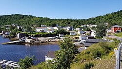
Hermitage-Sandyville is a small town on the south coast of Newfoundland, Canada, with a population of 404 people in the 2021 Census. The main source of income for the community is provided by the aquaculture industry, the local salmon plant and fishing.
New-Wes-Valley is a municipality in Newfoundland and Labrador, Canada.

Logy Bay-Middle Cove-Outer Cove is a town in the Canadian province of Newfoundland and Labrador. It is located within a 10 minutes' drive from downtown St. John's preceding the Town of Torbay on the eastern tip of the Avalon Peninsula.
Bay L'Argent is a town in the Canadian province of Newfoundland and Labrador.

St. Brendan's is a town in the Canadian province of Newfoundland and Labrador, situated in Shoal Cove on Cottel Island in Bonavista Bay. Other settlements on the island include Shalloway Cove, Haywards Cove, and Dock Cove. The town had a population of 125 in the Canada 2021 Census. St. Brendan's is inaccessible by road and is served by a daily ferry service from Burnside.

Witless Bay is a town on the Avalon Peninsula in the Canadian province of Newfoundland and Labrador. Located on the Irish Loop, 35 km south of the provincial capital, St. John's, Witless Bay is a small, scenic, traditional Newfoundland outport community. The town had a population of 1640 in the Canada 2021 Census. It is connected to the Witless Bay Ecological Reserve.

St. Bernard's-Jacques Fontaine is a town in the Canadian province of Newfoundland and Labrador. The town had a population of 433 in the Canada 2021 Census, a drop from 470 in 2011.

St. Jacques-Coomb's Cove is a town in the Canadian province of Newfoundland and Labrador. The town had a population of 546 in the Canada 2021 Census. It is located on the south coast of the island of Newfoundland on the north side of Fortune Bay, on the southern tip of the Connaigre Peninsula in what is now known as the Coast of Bays Region. The town consists of six communities, St. Jacques, English Harbour West, Mose Ambrose, Boxey, Coomb's Cove, and Wreck Cove, all nestled within the inlets along the coast. They all had their beginnings in the fisheries and the fisheries have always been the mainstay of employment in the communities. In recent years aquaculture was introduced in the area, providing employment for its residents.
The Connaigre Peninsula is a Canadian peninsula located on the south coast of the island of Newfoundland in the province of Newfoundland and Labrador. Harbour Breton is the largest population centre on the peninsula.