
Mount Bryce is a mountain at the southwestern corner of the Columbia Icefield, in British Columbia, Canada, near the border with Alberta. It can be seen from the Icefields Parkway.

Mount Brazeau is a mountain in Alberta, Canada.

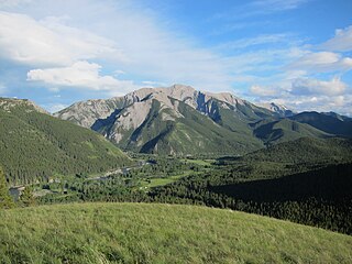
The Sawback Range is a mountain range of the Canadian Rockies that stretches from the Bow Valley in Alberta into southeastern Banff National Park.

The Rainbow Range is a small subrange of the Park Ranges subdivisions of the Northern Continental Ranges of the Rocky Mountains on the border between Alberta and British Columbia in Mount Robson Provincial Park.

Mount Lawrence Grassi is the tallest peak of the Ehagay Nakoda massif, a multi-peaked mountain located immediately south of the town of Canmore just east of the Spray Lakes road in Alberta's Canadian Rockies. The mountain sports two other subsidiary peaks with commemorative names: Ha Ling Peak on the northwestern end, and Miners Peak located southeast of Ha Ling Peak between Ha Ling Peak and Mount Lawrence Grassi. Another peak on the mountain is named Ship's Prow, which is on the Southeastern end of the mountain. The mountain is separated from Mount Rundle by Whiteman's Gap, and is separated to the South from The Three Sisters by Three Sisters Pass.

Signal Mountain was named in 1916 by Morrison P. Bridgland. It is located in the Maligne Range in Alberta.

Highwood Pass is a mountain pass in Kananaskis Country, Alberta, Canada. It lies west of Mount Rae and Mount Arethusa of the Misty Range, south of Elbow Pass. It lies within the Peter Lougheed Provincial Park on Alberta Highway 40. The Highwood River originates in the pass.
Elk Pass is a high mountain pass in the Canadian Rockies, traversing the continental divide. It connects the Elk Valley in the province of British Columbia with the Kananaskis Valley in Alberta.
Mount Farnham is British Columbia's 17th highest peak, and 21st most prominent. It was named after Paulding Farnham from New York. It is the highest peak in the Purcells.
Mount Talbot is located on the northern side of Shale Pass on the Alberta-British Columbia border. It was officially named on 4 November 1925 after Senator Peter Talbot (1854-1919), an early pioneer of the Lacombe region of central Alberta. A teacher and farmer, he turned to politics and became an elected representative of the Northwest Territories and later the province of Alberta. In 1906, Sir Wilfrid Laurier appointed him to the Senate of Canada.
Whiteshield Mountain is located at the northern boundary of Mount Robson Provincial Park on the Alberta-British Columbia border. It was named in 1924 because of the ice and snow on the eastern side of the mountain.
Treadmill Ridge is a mountain ridge located at the northern end of Mount Robson Provincial Park, on the Alberta/British Columbia border. It is Alberta's 98th most prominent mountain. It was named in 1923 by Arthur O. Wheele who believed that the mountain resembled a treadmill.
Upright Mountain is located east of the head of the Moose River at the NE side of Mount Robson Provincial Park on the Continental Divide marking the Alberta-British Columbia border. Arthur O. Wheeler named the mountain in 1911 as the strata of the mountain have been upheaved to an almost vertical position.
Salient Mountain is located just north of Miette Pass, at the NE end of Mount Robson Provincial Park on the Continental Divide marking the Alberta-British Columbia border. It is Alberta's 80th most prominent mountain. It was named in 1922 by Arthur O. Wheeler. It was noted to be the "sharpest" peak in the area.
Whitecrow Mountain is located at the head of the Fraser River in Mount Robson Provincial Park on the Continental Divide marking the Alberta-British Columbia border. It was named in 1922 by Arthur O. Wheeler for the number of white crows that were seen on the peak.
Mount Ptolemy is the highest mountain of the Flathead Range and is located on the Continental Divide along the provincial borders of Alberta and British Columbia. Situated 10 km (6.2 mi) southeast of Crowsnest Pass and 5 km (3 mi) northeast of Corbin, it is Alberta's 57th most prominent mountain. It was named in 1914 by Arthur Wheeler for its resemblance to a man sitting with folded arms. The mountain has also been known as Mummy Mountain.
Scarpe Mountain is located at the head of Commerce Creek and straddles the Continental Divide marking the Alberta-British Columbia border. It was named after the Scarpe River in France.
The Livingstone Range is a sub-range of the Canadian Rockies in Alberta, Canada. It forms the eastern boundary of the Rockies in the south of the province. Its northern boundary is the Highwood River and it extends to Crowsnest Pass in the south. The Livingstone and Oldman Rivers bound it to the west.

Ehagay Nakoda is a multipeaked massif located immediately south of the town of Canmore just east of the Spray Lakes road in Alberta's Canadian Rockies. The mountain sports two subsidiary peaks with commemorative names, Mount Lawrence Grassi and Ha Ling Peak on the northwestern end. It also sports two other named peaks: Ship's Prow on the southeastern side, and Miners Peak. The mountain is separated from Mount Rundle by Whiteman's Gap, and is separated to the South from The Three Sisters by Three Sisters Pass.
Mount Davidson is a 2,919-metre (9,577-foot) mountain summit located to the north of the head of Waiparous Creek, Municipal District of Bighorn No. 8, southwestern Alberta, Canada. Visible from Calgary, it is situated 18 km (11 mi) north of Lake Minnewanka. The first ascent of the mountain was made in October 1988 by Frank Campbell and Karl Nagy.
