Sayerwood South, New Jersey

Last updated

Sayerwood South, New Jersey
Location map of Middlesex County, New Jersey.svg
Red pog.svg
Sayerwood South
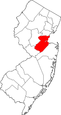
Location of Sayerwood South in Middlesex County Inset: Location of county within the state of New Jersey
USA New Jersey location map.svg
Red pog.svg
Sayerwood South
Sayerwood South (New Jersey)
Usa edcp location map.svg
Red pog.svg
Sayerwood South
Sayerwood South (the United States)
Coordinates: 40°23′50″N74°19′29″W / 40.39722°N 74.32472°W / 40.39722; -74.32472
Country Flag of the United States.svg  United States
State Flag of New Jersey.svg  New Jersey
County Middlesex
Township Old Bridge
Elevation
[1]
82 ft (25 m)
GNIS feature ID883194 [1]

Sayerwood South or Sayrewood South is an unincorporated community located within Old Bridge Township in Middlesex County, in the U.S. state of New Jersey. [2]

Related Research Articles

<span class="mw-page-title-main">Deans, New Jersey</span> Populated place in Middlesex County, New Jersey, US

Deans is an unincorporated community and census-designated place (CDP) in South Brunswick Township, Middlesex County, New Jersey, in the United States. As of the 2020 United States census, Deans had a population of 1,615.

<span class="mw-page-title-main">Locust, New Jersey</span> Populated place in Monmouth County, New Jersey, US

Locust is an unincorporated community located within Middletown Township in Monmouth County, in the U.S. state of New Jersey. It is situated along the north banks of the Navesink River and Claypit Creek. The area consists of mostly medium-to-large sized houses throughout the hilly terrain of this part of the township. The Oceanic Bridge connects Locust with Rumson to the south.

<span class="mw-page-title-main">Holmeson, New Jersey</span> Populated place in Monmouth County, New Jersey, US

Holmeson is an unincorporated community located within Millstone Township in Monmouth County, in the U.S. state of New Jersey. As it is located along County Route 537 through which the Monmouth–Ocean county line runs down the center, portions of the community are also located in Jackson Township. Owing to its location near Interstate 195 and Six Flags Great Adventure, the community is mostly made up of gas stations, restaurants, and small businesses though the Jackson Premium Outlets occupies land just south of the community.

<span class="mw-page-title-main">Chapel Hill, New Jersey</span> Populated place in Monmouth County, New Jersey, US

Chapel Hill is an unincorporated community located within Middletown Township, in Monmouth County, in the U.S. state of New Jersey. As its name implies, the area is on a high spot within the township between Fairview and Leonardo just south of the Naval Weapons Station Earle Waterfront Section. Unlike other areas of Middletown Township, the Chapel Hill section is not as developed with single-family homes; only a few housing developments are located off the area's main roads, Kings Highway and Chapel Hill Road. The rest of the area outside NWS Earle consists of horse farms and forestland.

<span class="mw-page-title-main">Cheesequake, New Jersey</span> Populated place in Middlesex County, New Jersey, US

Cheesequake is an unincorporated community located within Old Bridge Township in Middlesex County, in the U.S. state of New Jersey. Cheesequake is located along Route 34, south of Cheesequake State Park.

<span class="mw-page-title-main">Cottageville, New Jersey</span> Populated place in Middlesex County, New Jersey, US

Cottageville is an unincorporated community located within South Brunswick Township in Middlesex County, in the U.S. state of New Jersey. The settlement is located along Davidson Mill Road at the former Newark–Trenton Fast Line right-of-way, now a PSE&G transmission line corridor. The trolley stop at the settlement allowed for summer cottages to be built in the area leading to the area's name. Today, some of the older homes remain in addition to a summer camp, forest land, and PSE&G's Deans substation.

<span class="mw-page-title-main">Fresh Ponds, New Jersey</span> Populated place in Middlesex County, New Jersey, US

Fresh Ponds is an unincorporated community located within South Brunswick Township in Middlesex County, in the U.S. state of New Jersey. It is located in a rural portion of the township at the intersection of Fresh Ponds Road and Davidson Mill Road. Forest land, farms, homes, and a church are located around the settlement.

<span class="mw-page-title-main">Little Rocky Hill, New Jersey</span> Populated place in Middlesex County, New Jersey, US

Little Rocky Hill is an unincorporated community located within South Brunswick in Middlesex County and Franklin Township, Somerset County, in the U.S. state of New Jersey. The community is located atop a small hill east of the borough of Rocky Hill. The Middlesex–Somerset county line runs through the community along Old Road though elsewhere it follows Route 27. Carters Brook runs through the area flowing south.

<span class="mw-page-title-main">Sand Hills, South Brunswick, New Jersey</span> Populated place in Middlesex County, New Jersey, US

Sand Hills is an unincorporated community located within South Brunswick Township in Middlesex County, in the U.S. state of New Jersey. The settlement is named for Sand Hills, a small group of diabase hills which contains Middlesex County's highest point. The settlement is located approximately at the intersection of U.S. Route 1, Sand Hills Road, and Major Road. There is a small cluster of houses and small businesses on Major Road just south of US 1 while more housing developments are found on the north side of the highway. Fast food restaurants, stores, and repair shops line US 1 through the area; this area of US 1 also has large inclines on both sides of the hills to climb from the relatively low and flat areas of the Atlantic coastal plain.

Sayreville Station is a neighborhood in Sayreville in Middlesex County, in the U.S. state of New Jersey. Originally terminus of Raritan River Railroad's Sayreville Branch between Upper and Lower Sayreville. The spur was abandoned in 1978.

Shore Road Estates is an unincorporated community located within Monroe Township in Middlesex County, in the U.S. state of New Jersey.

<span class="mw-page-title-main">Wyckoffs Mills, New Jersey</span> Populated place in Middlesex County, New Jersey, US

Wyckoffs Mills is an unincorporated community located along the border of Cranbury and Monroe townships in Middlesex County, in the U.S. state of New Jersey. Located at the intersection of Wyckoff Mills Road and Wyckoffs Mills Road, the area only contains lots containing residential structures; the remainder of the land is made up of farmland and wetlands. The Millstone River flows to the south of the settlement and a 500-kilovolt transmission line crosses the farmland to the north and south.

<span class="mw-page-title-main">Bergerville, New Jersey</span> Populated place in Monmouth County, New Jersey, US

Bergerville is an unincorporated community located within Howell Township in Monmouth County, in the U.S. state of New Jersey. The area was originally developed as a resort bungalow community in the first half of the 20th century.

<span class="mw-page-title-main">Charleston Springs, New Jersey</span> Populated place in Monmouth County, New Jersey, US

Charleston Springs is an unincorporated community located within Millstone Township in Monmouth County, in the U.S. state of New Jersey. Stage Coach Road, also designated County Route 524, is the main road that runs through the settlement, with Ely Harmony Road as the intersecting road defining the locality. The Manalapan Brook runs to the west of the center of Charleston Springs and CR 537 runs to the south of the area. The Monmouth County-owned Charleston Springs Golf Course is located one mile (1.6 km) northeast of the center of Charleston Springs on CR 527.

<span class="mw-page-title-main">Freewood Acres, New Jersey</span> Populated place in Monmouth County, New Jersey, US

Freewood Acres is an unincorporated community located within Howell Township in Monmouth County, in the U.S. state of New Jersey. The area is made up of mostly single-story homes arranged along a street grid in the northern reaches of the Pine Barrens. U.S. Route 9 runs through the center of the community just north of its interchange with Interstate 195. The Land O'Pines Elementary School and Manasquan Reservoir County Park exist to the east of the community. It became the center of the Kalmyk American community in the latter part of the 20th century.

<span class="mw-page-title-main">Galilee, New Jersey</span> Populated place in Monmouth County, New Jersey, US

Galilee is an unincorporated community located within Monmouth Beach in Monmouth County, in the U.S. state of New Jersey. The area is named for the Biblical city of Galilee and was founded as a fishing village. Located at the northern extent of Monmouth Beach, it is located along the peninsula where it begins to greatly narrow between the Shrewsbury River and the Atlantic Ocean. Single family homes typically make up the ocean side of the peninsula while condominiums and a marina are located on the river side. The Sea Bright–Monmouth Beach Seawall passes through the community and continues to neighboring Sea Bright.

<span class="mw-page-title-main">Red Valley, New Jersey</span> Populated place in Monmouth County, New Jersey, US

Red Valley is an unincorporated community located within Upper Freehold Township in Monmouth County, in the U.S. state of New Jersey. The settlement is located at the intersection of County Route 526 and Red Valley Road (south) and Yellow Meetinghouse Road (north) near the township's eastern border with Millstone Township. Except for some single-family houses located along the roads in the area, the area is primarily made up of farmland.

<span class="mw-page-title-main">Neepaulakating Creek</span> Tributary of Papakating Creek

Neepaulakating Creek is a 2.4-mile long (3.8 km) tributary of Papakating Creek in Wantage Township in Sussex County, New Jersey in the United States. It is one of three streams feeding the Papakating Creek, a major contributor to the Wallkill River. Although the stream was dammed in the 1950s to create Lake Neepaulin as the focal point of a private residential development, the stream did not receive a name until 2002. Residents chose a name that combined elements of the names "Neepaulin" and "Papakating", and submitted a proposal to the United States Board of Geographic Names. The name was approved in 2004.

References

  1. 1 2 "Sayerwood South". Geographic Names Information System . United States Geological Survey, United States Department of the Interior.
  2. Google (February 14, 2015). "Sayerwood South, New Jersey" (Map). Google Maps . Google. Retrieved February 14, 2015.