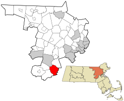
Sherborn, Massachusetts

Last updated

Sherborn, Massachusetts
Sherborn, MA Community Center.jpg
Sherborn Community Center
Seal of Sherborn, Massachusetts.png
Middlesex County Massachusetts incorporated and unincorporated areas Sherborn highlighted.svg
Location in Middlesex County in Massachusetts
Coordinates: 42°14′20″N71°22′13″W / 42.23889°N 71.37028°W / 42.23889; -71.37028
CountryUnited States
State Massachusetts
County Middlesex
Settled1652
Incorporated1674
Government
  Type Open town meeting
Area
  Total16.2 sq mi (41.9 km2)
  Land16.0 sq mi (41.3 km2)
  Water0.2 sq mi (0.6 km2)
Elevation
175 ft (53 m)
Population
 (2020)
  Total4,401
  Density275.1/sq mi (106.6/km2)
Time zone UTC-5 (Eastern)
  Summer (DST) UTC-4 (Eastern)
ZIP code
01770
Area code 508 / 774
FIPS code 25-61380
GNIS feature ID0618233
Website www.sherbornma.org

Sherborn is a town in Middlesex County, Massachusetts, United States. Located in Boston's MetroWest region, the community is within area code 508 and has the ZIP code 01770. As of the 2020 U.S. Census, the town population was 4,401. [1]

Contents

Sherborn shares its highly ranked public school system with the town of Dover. In addition to Dover, Sherborn is bordered by the towns of Natick, Framingham, Ashland, Millis, Holliston, and Medfield.

Geography

The town is located 18 miles (29 km) southwest of Boston. According to the United States Census Bureau, the town has a total area of 16.2 square miles (42 km2), of which 16.0 square miles (41 km2) is land and 0.2 square miles (0.52 km2), or 1.36%, is water, with much of that located in Farm Pond.

Demographics

Historical population
YearPop.±%
1850 1,043    
1860 1,129+8.2%
1870 1,062−5.9%
1880 1,401+31.9%
1890 1,381−1.4%
1900 1,483+7.4%
1910 1,428−3.7%
1920 1,558+9.1%
1930 943−39.5%
1940 1,022+8.4%
1950 1,245+21.8%
1960 1,806+45.1%
1970 3,309+83.2%
1980 4,049+22.4%
1990 3,989−1.5%
2000 4,200+5.3%
2010 4,119−1.9%
2020 4,401+6.8%
2022*4,372−0.7%
* = population estimate.
Source: United States census records and Population Estimates Program data. [2] [3] [4] [5] [6] [7] [8] [9] [10] [11] [12]

As of the census [13] of 2000, there were 4,200 people, 1,423 households, and 1,222 families residing in the town. The population density was 263.1 inhabitants per square mile (101.6/km2). There were 1,451 housing units at an average density of 90.9/sq mi (35.1/km2). The racial makeup of the town was 96.50% White, 0.38% African American, 0.05% Native American, 2.40% Asian, 0.26% from other races, and 0.40% from two or more races. Hispanic or Latino of any race were 1.12% of the population.

There were 1,423 households, out of which 46.2% had children under the age of 18 living with them, 77.5% were married couples living together, 6.3% had a female householder with no husband present, and 14.1% were non-families. 12.4% of all households were made up of individuals, and 6.0% had someone living alone who was 65 years of age or older. The average household size was 2.95 and the average family size was 3.22.

In the town, the population was spread out, with 31.9% under the age of 18, 3.2% from 18 to 24, 22.9% from 25 to 44, 30.7% from 45 to 64, and 11.3% who were 65 years of age or older. The median age was 41 years. For every 100 females, there were 93.4 males. For every 100 females age 18 and over, there were 89.6 males.

According to the 2007 U.S. census, the median income for a household in the town was $223,444, and the median income for a family was $164,063. Males had a median income of $181,291 versus $85,909 for females. The per capita income for the town was about $73,420. About 0.7% of families and 2.3% of the population were below the poverty line, including 2.4% of those under age 18 and 5.6% of those age 65 or over.
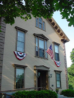
Education

There is a public elementary school called Pine Hill School. The majority of middle school and high school students in Sherborn attend the Dover-Sherborn Middle School and the Dover-Sherborn High School, respectively, which are both located in Dover, Massachusetts. There are also 2 preschools in Sherborn center, ECDC and Pine Hill preschool.

Notable people

See also

Related Research Articles

<span class="mw-page-title-main">Washington, Massachusetts</span> Town in Massachusetts, United States

Washington is a town in Berkshire County, Massachusetts, United States. It is part of the Pittsfield, Massachusetts, Metropolitan Statistical Area. The population was 494 at the 2020 census.

<span class="mw-page-title-main">Erving, Massachusetts</span> Town in Massachusetts, United States

Erving is a town in Franklin County, Massachusetts, United States. The population was 1,665 at the 2020 census. It is part of the Springfield, Massachusetts metropolitan statistical area.

<span class="mw-page-title-main">Brimfield, Massachusetts</span> Town in Massachusetts, United States

Brimfield is a town in Hampden County, Massachusetts, United States. The population was 3,694 at the 2020 census. It is part of the Springfield, Massachusetts Metropolitan Statistical Area.

<span class="mw-page-title-main">Tolland, Massachusetts</span> Town in Massachusetts, United States

Tolland is a town in Hampden County, Massachusetts, United States. It is part of the Springfield, Massachusetts Metropolitan Statistical Area. The population was 471 at the 2020 census, making it the smallest town in Hampden County by population.

<span class="mw-page-title-main">Wales, Massachusetts</span> Town in Massachusetts, United States

Wales is a town in Hampden County, Massachusetts, United States. The population was 1,838 at the 2020 census. It is part of the Springfield, Massachusetts Metropolitan Statistical Area.

<span class="mw-page-title-main">Westhampton, Massachusetts</span> Town in Massachusetts, United States

Westhampton is a town in Hampshire County, Massachusetts, United States. The population was 1,622 at the 2020 census. It is part of the Springfield, Massachusetts Metropolitan Statistical Area.

<span class="mw-page-title-main">North Reading, Massachusetts</span> Town in Massachusetts, United States

North Reading is a town in Middlesex County, Massachusetts, United States. The population was 15,554 at the 2020 census.

<span class="mw-page-title-main">Berlin, Massachusetts</span> Town in Massachusetts, United States

Berlin is a town in Worcester County, Massachusetts, United States. The town was first settled in 1665 and incorporated in 1812, and is governed under the open town meeting system. It is located 12 miles (19 km) northeast of Worcester and 29 miles (47 km) west of Boston. The population was 3,158 at the 2020 census.

<span class="mw-page-title-main">Boylston, Massachusetts</span> Town in Massachusetts, United States

Boylston is a town in Worcester County, Massachusetts, United States. The population was 4,849 at the 2020 census.

<span class="mw-page-title-main">Douglas, Massachusetts</span> Town in Massachusetts, United States

Douglas is a town in Southern Worcester County, Massachusetts, United States. The population was 8,983 at the 2020 census. It includes the sizable Douglas State Forest, managed by the Department of Conservation and Recreation (DCR).

<span class="mw-page-title-main">Holden, Massachusetts</span> Town in Massachusetts, United States

Holden is a town in Worcester County, Massachusetts, United States. The town was founded in 1741, and the Town Square was donated by John Hancock, former Governor of Massachusetts. The population was 19,905 at the 2020 census.

<span class="mw-page-title-main">Hubbardston, Massachusetts</span> Town in Massachusetts, United States

Hubbardston is a town in Worcester County, Massachusetts, United States. As of the 2020 U.S. census, the town population was 4,328. It is situated 18 miles north of Worcester and 53 miles west of Boston; it is distinguished in Massachusetts by being unusually high, at 1015 feet above sea level.

<span class="mw-page-title-main">New Braintree, Massachusetts</span> Town in Massachusetts, United States

New Braintree is a town in Worcester County, Massachusetts, United States. The population was 996 at the 2020 census.

<span class="mw-page-title-main">Phillipston, Massachusetts</span> Town in Massachusetts, United States

Phillipston is a town in Worcester County, Massachusetts, United States. The population was 1,724 at the 2020 census.

<span class="mw-page-title-main">Templeton, Massachusetts</span> Town in Massachusetts, United States

Templeton is a town in Worcester County, Massachusetts, United States. The population was 8,149 at the 2020 census. The town comprises four main villages: Templeton Center, East Templeton, Baldwinville, and Otter River.

<span class="mw-page-title-main">Hopedale, Massachusetts</span> Town in Massachusetts, United States

Hopedale is a town in Worcester County, Massachusetts, United States. It is located 25 miles southwest of Boston, in eastern Massachusetts. With origins as a Christian utopian community, the town was later home to Draper Corporation, a large loom manufacturer throughout the 20th century until its closure in 1980. Today, Hopedale has become a bedroom community for professionals working in Greater Boston and is home to highly ranked public schools. The population was 6,017 as of the 2020 census.

<span class="mw-page-title-main">Oxford, Massachusetts</span> Town in Massachusetts, United States

Oxford is a town in Worcester County, Massachusetts, United States. The population was 13,347 as of the 2020 United States Census.

<span class="mw-page-title-main">Dover, Massachusetts</span> Town in Massachusetts, United States

Dover is a town in Norfolk County, Massachusetts, United States. The population was 5,923 at the time of the 2020 United States Census. With a median income of more than $250,000, Dover is the wealthiest town in Massachusetts.

<span class="mw-page-title-main">Townsend, Massachusetts</span> Town in Massachusetts, United States

Townsend is a town in Middlesex County, Massachusetts, United States. The population was 9,127 at the 2020 census.

<span class="mw-page-title-main">North Brookfield, Massachusetts</span> Town in Massachusetts, United States

North Brookfield is a town in Worcester County, Massachusetts, United States. The population was 4,735 at the 2020 census.

References

  1. "Census - Geography Profile: Sherborn town, Middlesex County, Massachusetts". United States Census Bureau . Retrieved November 6, 2021.
  2. "Total Population (P1), 2010 Census Summary File 1". American FactFinder, All County Subdivisions within Massachusetts. United States Census Bureau. 2010.
  3. "Massachusetts by Place and County Subdivision - GCT-T1. Population Estimates". United States Census Bureau. Retrieved July 12, 2011.
  4. "1990 Census of Population, General Population Characteristics: Massachusetts" (PDF). US Census Bureau. December 1990. Table 76: General Characteristics of Persons, Households, and Families: 1990. 1990 CP-1-23. Retrieved July 12, 2011.
  5. "1980 Census of the Population, Number of Inhabitants: Massachusetts" (PDF). US Census Bureau. December 1981. Table 4. Populations of County Subdivisions: 1960 to 1980. PC80-1-A23. Retrieved July 12, 2011.
  6. "1950 Census of Population" (PDF). Bureau of the Census. 1952. Section 6, Pages 21-10 and 21-11, Massachusetts Table 6. Population of Counties by Minor Civil Divisions: 1930 to 1950. Retrieved July 12, 2011.
  7. "1920 Census of Population" (PDF). Bureau of the Census. Number of Inhabitants, by Counties and Minor Civil Divisions. Pages 21-5 through 21-7. Massachusetts Table 2. Population of Counties by Minor Civil Divisions: 1920, 1910, and 1920. Retrieved July 12, 2011.
  8. "1890 Census of the Population" (PDF). Department of the Interior, Census Office. Pages 179 through 182. Massachusetts Table 5. Population of States and Territories by Minor Civil Divisions: 1880 and 1890. Retrieved July 12, 2011.
  9. "1870 Census of the Population" (PDF). Department of the Interior, Census Office. 1872. Pages 217 through 220. Table IX. Population of Minor Civil Divisions, &c. Massachusetts. Retrieved July 12, 2011.
  10. "1860 Census" (PDF). Department of the Interior, Census Office. 1864. Pages 220 through 226. State of Massachusetts Table No. 3. Populations of Cities, Towns, &c. Retrieved July 12, 2011.
  11. "1850 Census" (PDF). Department of the Interior, Census Office. 1854. Pages 338 through 393. Populations of Cities, Towns, &c. Retrieved July 12, 2011.
  12. "City and Town Population Totals: 2020-2022". United States Census Bureau . Retrieved November 23, 2023.
  13. "U.S. Census website". United States Census Bureau . Retrieved January 31, 2008.
  14. "Cattle Annie & Little Britches". Ranch Diva Outfitters. Archived from the original on January 17, 2012. Retrieved December 27, 2012.
  15. "Funeral of Prof. Hill on Sunday". The Boston Post . August 19, 1916. p. 10. Retrieved January 22, 2024 via newspapers.com.