Shockoe Valley

Last updated
Historic Shockoe Valley
17th Street, Richmond, Virginia.JPG
View north on 17th Street
USA Virginia location map.svg
Red pog.svg
Usa edcp location map.svg
Red pog.svg
LocationRoughly bounded by the James River, 12th, Main, 14th, Broad, I-95, Clay, Cedar, Marshall, 21st, Franklin, 25th, Main, and Peach Sts., Richmond, Virginia
Coordinates 37°31′56″N77°25′29″W / 37.53222°N 77.42472°W / 37.53222; -77.42472 Coordinates: 37°31′56″N77°25′29″W / 37.53222°N 77.42472°W / 37.53222; -77.42472
Area129 acres (52 ha)
Architectural styleMid 19th Century Revival, Late 19th and 20th Century Revivals, Late Victorian
NRHP reference No. 83003308 [1]
VLR No.127-0344
Significant dates
Added to NRHPFebruary 24, 1983
Designated VLRJuly 21, 1981; August 23, 2007 [2]

Shockoe Valley is an area in Richmond, Virginia, just east of downtown, along the James River, and is the entertainment center of the city. Located between Shockoe Hill and Church Hill, Shockoe Valley contains much of the land included in Colonel William Mayo's 1737 plan of Richmond, making it one of the city's oldest neighborhoods. Shockoe Valley encompasses the smaller neighborhoods of Shockoe Slip, Shockoe Bottom and Tobacco Row along Cary Street.

Contents

History

Shockoe Valley began developing in the late 18th century following the move of the state capital to Richmond, aided by the construction of Mayo's bridge across the James River (ultimately succeeded by the modern 14th Street Bridge), as well as the siting of key tobacco industry structures, such as the public warehouse, tobacco scales, and the Federal Customs House in or near the district. [3]

On the eve of the fall of Richmond to the Union Army in April 1865, evacuating Confederate forces were ordered to set fire to the city's tobacco warehouses. The fires spread, and completely destroyed Shockoe Slip and several other districts. The district was quickly rebuilt in the late 1860s, flourishing further in the 1870s, and forming much of its present historic building stock. [3]

Throughout the 19th Century, Shockoe Valley was the center of Richmond's commerce with ships pulling into port from the James River. Goods coming off these ships were warehoused and traded in Shockoe Valley.

Up until the end of the American Civil War in 1865, the area played a major role in the history of slavery in the United States, serving as the second largest slave trading center in the country, second to New Orleans. Profits from the trade in human beings fueled the creation of wealth for Southern whites and drove the economy in Richmond, leading 15th Street to be known as Wall Street in the antebellum period, with the surrounding blocks home to more than 69 slave dealers and auction houses. [4] In 2006, archaeological excavations were begun on the former site of Lumpkin's Jail. [5]

On the eve of the fall of Richmond to the Union Army in April 1865, evacuating Confederate forces were ordered to set fire to the city's tobacco warehouses. The fires spread, and completely destroyed Shockoe Slip and several other districts. The district was quickly rebuilt in the late 1860s, flourishing further in the 1870s, and forming much of its present historic building stock. [3] Architecturally, many of the buildings were constructed during the rebuilding following the Evacuation Fire of 1865, especially in a commercial variant of the Italianate style, including a 1909 fountain, dedicated to "one who loved animals." [6] The buildings in the district, which historically housed a variety of offices, wholesale and retail establishments, are now primarily restaurants, shops, offices, and apartments. [3] It warehoused many of the city's goods, mostly tobacco. The district began declining in the 1920s, as other areas of the city rose in prominence with the advent of the automobile. Numerous structures would be demolished and cleared, including (in the 1950s), the Tobacco Exchange, which had been at the heart of the district. [3] Up until they moved from Tobacco Row in the 1980s, the area was home to many of the country's largest tobacco companies.

Redevelopment

Beginning in the 1960s and accelerating in the 1970s, Shockoe was redeveloped as a commercial and entertainment district; the nightlife district came just after Richmond passed liquor-by-the-drink laws, and when the so-called fern bar became popular across the United States. The restoration came at the time of an increased interest in historic preservation around the time of the Bicentennial, with the district being added to the National Register of Historic Places in 1972. Early pioneer restaurants included The Tobacco Company, Stuffy's Going Bananas, Commercial Cafe and Sam Miller's, the last two being revived restaurant names from Richmond's 19th century.

It became a major entertainment district in the last two decades of the 20th century. After centuries of periodic flooding by the James River, development was greatly stimulated by the completion of Richmond's James River Flood Wall and the Canal Walk in 1995. Ironically, the next flooding disaster came not from the river, but from Hurricane Gaston which brought extensive local tributary flooding along the basin of Shockoe Creek and did extensive damage to the area in 2004, with businesses being shut down and many buildings condemned.

Shockoe also included some of the earliest rehabilitated downtown apartments; at the time of the restoration asphalt paving was removed to expose historic Belgian block streets.

A major boom in residential growth was created in the mid-1990s when old warehouses in Tobacco Row were converted into warehouses. Since then, more vacant buildings have been replaced with residential dwellings and new ones have been built. Furthermore, more quality restaurants have moved into the area. Unfortunately, the area lacks retail and tourism. That is expected to change with the Revitalize RVA plan which could attract new development of apartments, a grocery store, and a hotel, all surrounding a stadium. Other projects include the revamping of the 17th Street Farmer's Market into an Open-air pedestrian mall with al fresco dining for the restaurants, the Main Street Station's Train Shed into an urban market with a bike storage facility and bus Rapid Transit station, and Lumpkin's Jail into the Slavery and Freedom Heritage Center. The future of Shockoe is said to be Richmond's center for entertainment and tourism.

Related Research Articles

Richmond, Virginia Capital city of Virginia, United States

Richmond is the capital city of the Commonwealth of Virginia in the United States. It is the center of the Richmond Metropolitan Statistical Area (MSA) and the Greater Richmond Region. Richmond was incorporated in 1742 and has been an independent city since 1871. As of the 2010 census, the city's population was 204,214; in 2020, the population had grown to 226,610, making Richmond the fourth-most populous city in Virginia. The Richmond Metropolitan Area has a population of 1,260,029, the third-most populous metro in the state.

Danville, Virginia Independent city in Virginia, United States

Danville is an independent city in the Commonwealth of Virginia in the United States, located in the Southside Virginia region and on the fall line of the Dan River. It was a major center of Confederate activity during the American Civil War, due to its strategic location on the Richmond and Danville Railroad, and in April 1865 it briefly served as the final capital of the Confederacy before the South surrendered.

North Loop, Minneapolis Neighborhood in Hennepin, Minnesota, United States

The North Loop, also commonly called The Warehouse District, is a neighborhood of the Central community of Minneapolis, Minnesota that was Minneapolis’s main commercial district during the city's years as a midwestern shipping hub. Although only a little commercial shipping is still done in the neighborhood, the historic warehouses still dominate the neighborhood. Some of these buildings have been repurposed into restaurants, shops, and apartments.

Oregon Hill United States historic place

Oregon Hill is a historic working-class neighborhood in Richmond, Virginia. Oregon Hill overlooks the James River and Belle Isle, and provides access to Hollywood Cemetery. Due to the neighborhood's proximity to the Monroe Park Campus of Virginia Commonwealth University, the neighborhood is sometimes referred to as a student quarter because of its high college student population.

Manchester, Richmond, Virginia Former Independent City in Virginia, United States of America

Manchester is a former independent city in Virginia in the United States. Prior to receiving independent status, it served as the county seat of Chesterfield County, between 1870 and 1876. Today, it is a part of the city of Richmond, Virginia.

Tobacco Row, Richmond

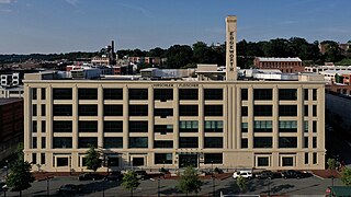
Tobacco Row is a collection of tobacco warehouses and cigarette factories in Richmond, Virginia adjacent to the James River and Kanawha Canal near its eastern terminus at the head of navigation of the James River.

White House of the Confederacy Historic house in Virginia, United States

The White House of the Confederacy is a historic house located in the Court End neighborhood of Richmond, Virginia. Built in 1818, it was the main executive residence of the sole President of the Confederate States of America, Jefferson Davis, from August 1861 until April 1865. It was viewed as the Confederate States counterpart to the White House in Washington, D.C.

History of Richmond, Virginia

The history of Richmond, Virginia, as a modern city, dates to the early 17th century, and is crucial to the development of the colony of Virginia, the American Revolutionary War, and the Civil War. After Reconstruction, Richmond's location at the falls of the James River helped it develop a diversified economy and become a land transportation hub.

This article is about the many neighborhoods and districts in the Greater Richmond, Virginia area. Note that this article is an attempt to be inclusive of the broader definitions of the areas which are often considered part of the Greater Richmond Region, based on their urban or suburban character and nature, rather than by strictly political boundaries.

Downtown Richmond, Virginia

Downtown Richmond is the central business district of Richmond, Virginia. It is generally defined as being bound by Belvidere Street to the west, I-95 to the north and east, and the James River to the south. The Fan district borders it to the west, Highland Park to the north, Church Hill to the east, and Manchester to the south.

Shockoe Bottom United States historic place

Shockoe Bottom is an area in Richmond, Virginia, just east of downtown, along the James River. Located between Shockoe Hill and Church Hill, Shockoe Bottom contains much of the land included in Colonel William Mayo's 1737 plan of Richmond, making it one of the city's oldest neighborhoods.

Shockoe Slip United States historic place

Shockoe Slip is a district in the downtown area of Richmond, Virginia. The name "slip" referred to a narrow passageway leading from Main Street to where goods were loaded and unloaded from the former James River and Kanawha Canal. The rough boundaries of Shockoe Slip include 14th Street, Main Street, Canal Street and 12th Street.
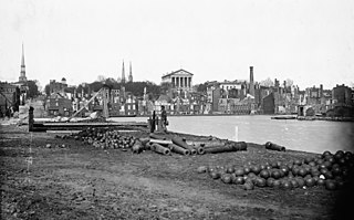
Court End Historic neighborhood of Richmond, Virginia, United States

Court End is a neighborhood in Richmond, Virginia, that sits to the north of the Capitol Square and East Broad Street. It developed in the Federal era, after Virginia's capital moved from Williamsburg.

Shockoe Hill Cemetery Historic cemetery in Virginia, United States

The Shockoe Hill Cemetery is a historic cemetery located on Shockoe Hill in Richmond, Virginia.

Lumpkins Jail

Lumpkin's Jail, also known as "the Devil's half acre", was a holding facility, or slave jail, located in Richmond, Virginia, just three blocks from the state capitol building. More than five dozen firms traded in enslaved human beings within blocks of Richmond's Wall Street between 14th and 18th Streets between the 1830s and the end of the American Civil War. Its final and most notorious owner, Robert Lumpkin, bought and sold slaves throughout the South for well over twenty years, and Lumpkin's Jail became Richmond's largest slave-holding facility.

Barton Heights Historic house in Virginia, United States

Barton Heights is a streetcar suburb neighborhood and former town in the Northside area of Richmond, Virginia. The area was primarily developed between 1890 and the 1920s.

The following is a timeline of the history of the city of Richmond, Virginia, United States

Scottsville Historic District Historic district in Virginia, United States

Scottsville Historic District is a national historic district located at Scottsville, Albemarle County and Fluvanna County, Virginia. The district encompasses 153 contributing buildings, 1 contributing site, and 4 contributing structures in the town of Scottsville. The district includes commercial, residential, religious, factory and warehouse buildings in a variety of popular architectural styles including Federal, Georgian, Greek Revival, Gothic Revival, Italianate, Queen Anne, Prairie, Colonial Revival, and Craftsman. Notable buildings include Scottsville High School (1920), Riverview (1817), Chester (1847), Belle Haven, Oakwood, Herndon House (1800), The Tavern (mid-1700s), Scottsville Presbyterian Church (1832), Disciples Church (1846), Coleman's Store (1914), and the Fore House (1732). Located in the district and separately listed are Cliffside and Mount Walla.

Main Street Banking Historic District Historic district in Virginia, United States

The Main Street Banking Historic District is a national historic district located in downtown Richmond, Virginia. The district encompasses 19 contributing buildings located south of the Virginia State Capitol and west of the Shockoe Slip Historic District. It is the location of a number of buildings built for or occupied by banking institutions. The district includes representative examples of the Late Victorian and International Style architecture built between about 1865 and 1965. Notable buildings include the Virginia Employment Commission Building (1960), the 700 Building (1964), the Ross Building (1964), the Fidelity Building (1965). Located in the district is the separately listed First National Bank Building.

Shockoe Hill African Burying Ground

The Shockoe Hill African Burying Ground was established by the city of Richmond, Virginia, for the interment of free people of color, and the enslaved. The heart of this now invisible burying ground is located at 1305 N 5th St. It was created as the replacement for the Burial Ground for Negroes, now also called the African Burial Ground, located in Shockoe Bottom. The Burial Ground for Negroes was closed in 1816 upon the opening of this new African Burying Ground on Shockoe Hill. It is one of Virginia's most endangered historic places.

References

  1. "National Register Information System". National Register of Historic Places . National Park Service. March 13, 2009.
  2. "Virginia Landmarks Register". Virginia Department of Historic Resources. Retrieved 19 March 2013.
  3. 1 2 3 4 5 "Shockoe Slip Historic District National Register Nomination – Boundary Increase" (PDF). Virginia Department of Historic Resources. Retrieved 8 June 2011.
  4. Trammel, Jack (2012). The Richmond Slave Trade: The Economic Backbone of the Old Dominion. The History Press. ISBN   9781609494131.
  5. Laird, Matthew. "Preliminary Archaeological Investigation of the Lumpkin's Jail Site" (PDF). VCU Library. Retrieved 6 March 2014.
  6. "Shockoe Slip". Historic Richmond Foundation.