
Beaghmore is a complex of early Bronze Age megalithic features, stone circles and cairns, 8.5 miles north west of Cookstown, County Tyrone in Northern Ireland, on the south-east edge of the Sperrin Mountains.
Donegore is the name of a hill, a townland, a small cluster of residences, and a civil parish in the historic barony of Antrim Upper, County Antrim, Northern Ireland. Donegore lies approximately 5 miles (8 km) east of Antrim town. 154 acres of the townland lies in the civil parish of Grange of Nilteen.

Tobergill is a townland of 1,044 acres in County Antrim, Northern Ireland. Lying on the western aspect of Donegore hill, it is situated in the civil parish of Donegore and the historic barony of Antrim Upper.

Dunadry is a hamlet and townland 3 miles (5 km) from Antrim in County Antrim, Northern Ireland. It is situated in the civil parish of Grange of Nilteen and the historic barony of Antrim Upper. It is within the Antrim and Newtownabbey Borough Council area. It had a population of 430 people in the 2011 Census..
Dunamuggy is a townland of 172 acres in County Antrim, Northern Ireland. It is situated in the civil parish of Donegore and the historic barony of Antrim Upper.

Ballygally or Ballygalley is a village and holiday resort in County Antrim, Northern Ireland which lies on the Antrim coast, approximately 3 miles north of Larne. It is also a townland of 769 acres and is situated in the civil parish of Carncastle and the historic barony of Glenarm Upper. It had a population of 821 in the 2011 Census. It is located within the Mid and East Antrim Borough Council area.

Carrickmore is a village in County Tyrone, Northern Ireland. It is situated in the historic barony of Omagh East and the civil parish of Termonmaguirk between Cookstown, Dungannon and Omagh. It had a population of 612 in the 2001 Census. In the 2011 Census 2,330 people lived in the Termon Ward, which covers the Carrickmore and Creggan areas.
Monkstown is a townland and electoral ward in County Antrim, Northern Ireland. It is within the urban area of Newtownabbey and the Antrim and Newtownabbey Borough Council area. The townland was previously called Ballynamanagh It is also situated in the civil parish of Carnmoney and the historic barony of Belfast Lower.
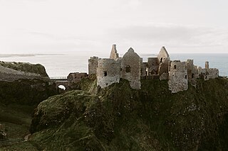
Dunluce Castle is a now-ruined medieval castle in Northern Ireland, the seat of Clan McDonnell. It is located on the edge of a basalt outcropping in County Antrim, and is accessible via a bridge connecting it to the mainland. The castle is surrounded by extremely steep drops on either side, which may have been an important factor to the early Christians and Vikings who were drawn to this place where an early Irish fort once stood.

Ballystrudder or Ballystruder is a small village and townland on Islandmagee in County Antrim, Northern Ireland. It is situated in the historic barony of Belfast Lower and the civil parish of Islandmagee. It is part of Mid and East Antrim Borough Council. It had a population of 992 people in the 2011 Census.

Shanmaghery or Shanmaghry is a small hamlet and townland in County Tyrone, Northern Ireland, situated three miles from Pomeroy and three miles from Galbally. It is situated in the barony of Dungannon Middle and the civil parish of Pomeroy and covers an area of 426 acres. In 1841 the population of the townland was 193 people and in 1851 it was 161 people. "Paul's Planting" was a notable landmark on top of the hill.
Derry is a townland in the civil parish of Ballyphilip in the barony of Ards Upper, County Down, in Northern Ireland. It is near Portaferry on the Ards Peninsula. The townland has remains of two small ruined churches.
Aghalislone is a townland of 664 acres in County Antrim, Northern Ireland. It is situated in the civil parish of Derriaghy and is split between the historic Baronies of Massereene Upper and Belfast Upper.
Antynanum is a townland in County Antrim, Northern Ireland. It is situated in the historic barony of Antrim Lower and the civil parish of Racavan and covers an area of 450 acres.

Ault,, is a townland of 367 acres in County Antrim, Northern Ireland. It is situated in the civil parish of Tickmacrevan and the historic barony of Glenarm Lower.

White Park, County Antrim is a townland of 170 acres in County Antrim, Northern Ireland. It is situated in the civil parish of Ballintoy and the historic barony of Cary.

Ballyclaverty is a townland of 339 acres in County Antrim, Northern Ireland. It is situated in the civil parish of Donegore and the historic barony of Antrim Upper.
Altanagh is a townland in County Tyrone, Northern Ireland. It is situated in the historic barony of Omagh East and the civil parish of Termonmaguirk and covers an area of 971 acres.
Moyadam is a townland of 685 acres in County Antrim, Northern Ireland. It is situated in the civil parish of Grange of Nilteen and the historic barony of Antrim Upper.
Ballydown is a townland of 210 acres in County Antrim, Northern Ireland. It is situated in the civil parish of Islandmagee and the historic barony of Belfast Lower.

