Related Research Articles

Longitude is a geographic coordinate that specifies the east–west position of a point on the surface of the Earth, or another celestial body. It is an angular measurement, usually expressed in degrees and denoted by the Greek letter lambda (λ). Meridians are semicircular lines running from pole to pole that connect points with the same longitude. The prime meridian defines 0° longitude; by convention the International Reference Meridian for the Earth passes near the Royal Observatory in Greenwich, England on the island of Great Britain. Positive longitudes are east of the prime meridian, and negative ones are west.

The geographic coordinate system (GCS) is a spherical or ellipsoidal coordinate system for measuring and communicating positions directly on the Earth as latitude and longitude. It is the simplest, oldest and most widely used of the various spatial reference systems that are in use, and forms the basis for most others. Although latitude and longitude form a coordinate tuple like a cartesian coordinate system, the geographic coordinate system is not cartesian because the measurements are angles and are not on a planar surface.

Celestial navigation, also known as astronavigation, is the practice of position fixing using stars and other celestial bodies that enables a navigator to accurately determine their actual current physical position in space without having to rely solely on estimated positional calculations, commonly known as "dead reckoning", made in the absence of satellite navigation or other similar modern electronic or digital positioning means.
A satellite dish is a dish-shaped type of parabolic antenna designed to receive or transmit information by radio waves to or from a communication satellite. The term most commonly means a dish which receives direct-broadcast satellite television from a direct broadcast satellite in geostationary orbit.
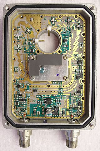
A low-noise block downconverter (LNB) is the receiving device mounted on satellite dishes used for satellite TV reception, which collects the radio waves from the dish and converts them to a signal which is sent through a cable to the receiver inside the building. Also called a low-noise block, low-noise converter (LNC), or even low-noise downconverter (LND), the device is sometimes inaccurately called a low-noise amplifier (LNA).
Satellite Internet access is Internet access provided through communication satellites. Modern consumer grade satellite Internet service is typically provided to individual users through geostationary satellites that can offer relatively high data speeds, with newer satellites using Ku band to achieve downstream data speeds up to 506 Mbit/s. In addition, new satellite internet constellations are being developed in low-earth orbit to enable low-latency internet access from space.
Bell Satellite TV is the division of BCE Inc. that provides satellite television service across Canada. It launched on September 10, 1997. As of April 2017, Bell Satellite TV provides over 700 channels to over 1 million subscribers. Its major competitors include satellite service Shaw Direct, as well as various cable and communications companies across Canada.
DiSEqC is a special communication protocol for use between a satellite receiver and a device such as a multi-dish switch or a small dish antenna rotor. DiSEqC was developed by European satellite provider Eutelsat, which now acts as the standards agency for the protocol.
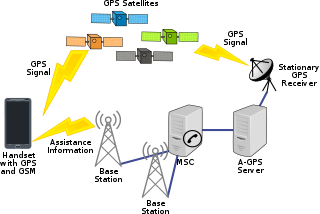
Assisted GNSS (A-GNSS) is a GNSS augmentation system that often significantly improves the startup performance—i.e., time-to-first-fix (TTFF)—of a global navigation satellite system (GNSS). A-GNSS works by providing the necessary data to the device via a radio network instead of the slow satellite link, essentially "warming up" the receiver for a fix. When applied to GPS, it is known as assisted GPS or augmented GPS. Other local names include A-GANSS for Galileo and A-Beidou for BeiDou.

A multiswitch is a device used with a dual or quattro LNB to distribute satellite TV signals to multiple receivers from a single dish and LNB.

Single-cable distribution is a satellite TV technology that enables the delivery of broadcast programming to multiple users over a single coaxial cable, and eliminates the numerous cables required to support consumer electronics devices such as twin-tuner digital video recorders (DVRs) and high-end receivers.
A monoblockLNB is a type of low-noise block downconverter used in communications satellite reception, this multiple combined LNBs is the simplest solution to achieve multifeed reception for two, three or four satellites.

Satellite television is a service that delivers television programming to viewers by relaying it from a communications satellite orbiting the Earth directly to the viewer's location. The signals are received via an outdoor parabolic antenna commonly referred to as a satellite dish and a low-noise block downconverter.

A free-to-air or FTA Receiver is a satellite television receiver designed to receive unencrypted broadcasts. Modern decoders are typically compliant with the MPEG-2/DVB-S and more recently the MPEG-4/DVB-S2 standard for digital television, while older FTA receivers relied on analog satellite transmissions which have declined rapidly in recent years.

The Squarial was a satellite antenna used for reception of the now defunct British Satellite Broadcasting television service (BSB). The Squarial was a flat plate satellite antenna, built to be unobtrusive and unique. BSB were counting on the form factor of the antenna to clearly differentiate themselves from their competitors at the time. At the time of development, satellite installations usually required a 90 cm dish in order to receive a clear signal from the transmitting satellite. The smaller antenna was BSB's unique selling point and was heavily advertised in order to attract customers to their service.
Automatic Tracking Satellite Dishes are satellite dishes used while a vehicle, boat or ship is in motion. Automatic tracking satellite dishes utilize gyroscopes, GPS position sensors, and uses unique satellite identification data and an integrated DVB decoder to aid in identification of the satellite that it is pointing at.
SES Broadband is a two-way satellite broadband Internet service available across Europe, which launched in March 2007, and uses the Astra series of geostationary satellites.

A Duo LNB is a double low-noise block downconverter (LNB) developed by SES for the simultaneous reception of satellite television signals from both the Astra 23.5°E and Astra 19.2°E satellite positions.
Saorsat is a free-to-air satellite service in Ireland. The service launched on 3 May 2012.

SAT>IP specifies an IP-based client–server communication protocol for a TV gateway in which SAT>IP servers, connected to one or more DVB broadcast sources, send the program selected and requested by an SAT>IP client over an IP based local area network in either unicast for the one requesting client or multicast in one datastream for several SAT>IP clients.
References
- ↑ Heinrichs, Tim. "What does " DiSEqC " stand for?" (PDF). Archived from the original (PDF) on 2014-08-12.