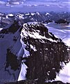
Mount Assiniboine, also known as Assiniboine Mountain, is a pyramidal peak mountain on the Great Divide, on the British Columbia/Alberta border in Canada.

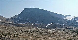
Mount Columbia is a mountain located in the Winston Churchill Range of the Rocky Mountains. It is the highest point in Alberta, Canada, and is second only to Mount Robson for height and topographical prominence in the Canadian Rockies. It is located on the border between Alberta and British Columbia on the northern edge of the Columbia Icefield. Its highest point, however, lies within Jasper National Park in Alberta.

Deltaform Mountain is one of the mountains in the Valley of the Ten Peaks, located on the Continental Divide on the border of British Columbia and Alberta, and also on the border between Banff and Kootenay National Parks in Canada. The mountain was originally named Saknowa by Samuel Allen but Walter Wilcox named it to its official title in 1897 as it resembles the Greek letter delta.

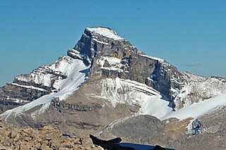
Mount Lyell is a mountain on the Alberta–British Columbia border in western Canada. Comprising five distinct summits, Mount Lyell reaches a height of 3,498 m (11,476 ft). The mountain was named by James Hector in 1858 in recognition of Scottish geologist Sir Charles Lyell.

Mount Sir Sandford is the highest mountain of the Sir Sandford Range and the highest mountain in the Selkirk Mountains of southeastern British Columbia, Canada. It is the 12th highest peak in the province. The mountain was named after Sir Sandford Fleming, a railway engineer for the Canadian Pacific Railway.

Mount Goodsir is the highest mountain in the Ottertail Range, a subrange of the Park Ranges in British Columbia. It is located in Yoho National Park, near its border with Kootenay National Park. The mountain has two major summits, the South Tower and the North Tower, 3,525 metres (11,565 ft).

Mount Balfour is a mountain located on the Continental Divide, part of the border between British Columbia and Alberta, in the Waputik Range in the Park Ranges of the Canadian Rockies. It is the 71st highest peak in Alberta and the 113th highest in British Columbia; it is also the 52nd most prominent in Alberta.
Mount Morkill is located on the border of Alberta and British Columbia, near McBride which is a town in British Columbia, Canada. There is a subpeak to the southwest of the main peak, at an elevation of 2,185 m (7,169 ft) named The Gazetted Peak. It was named in 1965 after D.B. Morkill, a British Columbia land surveyor.

Mount Phillips is a mountain located on the border of Jasper National Park (Alberta) and Mount Robson Provincial Park. It is Alberta's 61st highest peak, and British Columbia's 84th highest peak. It was named in 1923 by J. Norman Collie after Donald "Curly" Phillips, a Jasper area outfitter and guide who made the disputed first ascent of Mount Robson in 1909.

Ernest Peak - a.k.a. Lyell 3, L3 or Mt. Lyell - is the central and highest peak of five distinct subpeaks on Mount Lyell (Canada) and is located on the border of Alberta and British Columbia.. It was named in 1972 by Sydney R. Vallance after Ernest Feuz Jr.

Christian Peak - a.k.a. Lyell 5 or L5 - is the least tall of five distinct subpeaks on Mount Lyell (Canada) and is located on the border of Alberta and British Columbia. It was named in 1972 by Sydney R. Vallance after Christian Hässler, Jr.
Mistaya Mountain is located on the border of Alberta and British Columbia, on the Continental Divide. It was named in 1918. Mistaya is either the Cree name for "grizzly bear" or is the Stoney word for "much wind".
Mount Barnard is located on the border of Alberta and British Columbia, NW of the head of Waitabit Creek and North of Golden. It is the 30th highest peak in Alberta and the 42nd highest peak in British Columbia. It was named in 1917 by boundary surveyors after Sir Francis Stillman Barnard, a Lieutenant Governor of BC during the 1910s. It should not be confused with the higher Californian peak of the same name.
Mount Barlow is located on the Continental Divide along the border of Alberta and British Columbia at the southern edge of the Freshfield Icefield in Banff National Park. It was named in 1916 by D.B. Dowling after Dr. Alfred Ernest Barlow, a cartographer with the Geological Survey of Canada who died in the 1914 Empress of Ireland disaster.

Mount Rhondda is located on the Continental Divide straddling the Canadian provinces of Alberta and British Columbia. It was named in 1917 by the Interprovincial Boundary Survey after David Alfred Thomas, First Viscount Baron Rhondda.

Mount Foch is a 3,194-metre (10,479-foot) mountain summit located on the border of Alberta and British Columbia on the Continental Divide. It was named in 1918 after Marshal of France Ferdinand Foch.

Warrior Mountain is located north of Mount Joffre in Height of the Rockies Provincial Park and straddles the Continental Divide marking the Alberta-British Columbia border. It was named in 1917 after HMS Warrior. The first ascent of the mountain was made in 1930 by Kate (Katie) Gardiner and Walter Feuz. The duo also made the first ascents of nearby Mount Sarrail and Mount Lyautey that same year.

Pinnacle Mountain is a 3,070-metre (10,070-foot) mountain summit in Banff National Park in Alberta, Canada. It's part of the Bow Range, which is a sub-range of the Canadian Rockies. The nearest higher peak is Eiffel Peak, 1.0 km (0.62 mi) to the southwest. Mount Temple is situated immediately northeast of Pinnacle Mountain, with Sentinel Pass as the low point between the two.
Mount St. Bride is a prominent 3,315-metre (10,876 ft) mountain summit located in Banff National Park, in the Rocky Mountains of Alberta. It is the highest point in the Sawback Range. Its nearest higher peak is Cataract Peak, located 18.8 km (11.7 mi) to the northwest. Mount St. Bride is situated 2.0 km (1.2 mi) to the south of Mount Douglas, near the headwaters of the Red Deer River.

Mount Mummery is a 3,328-metre (10,919 ft) glaciated double summit mountain located in the Canadian Rockies of British Columbia, Canada. It is the highest point in the Mummery Group, and fourth-highest in the Freshfield Icefield Ranges. The mountain is situated 42 km (26 mi) north of Golden on the southern edge of the Freshfield Icefield, in the Blaeberry Valley, less than 4 km (2.5 mi) from the Continental Divide. The mountain was named in 1898 by J. Norman Collie after Albert F. Mummery (1855-1895), a famous British mountaineer who perished attempting to climb Nanga Parbat in the Himalayas. Collie named many peaks in the Canadian Rockies, and was a climbing companion who accompanied Mummery on the Nanga Parbat expedition. Around the same time, nearby Nanga Parbat Mountain was also named by Collie. Mount Mummery's name was officially adopted March 31, 1924, when approved by the Geographical Names Board of Canada. The first ascent of the mountain was made in 1906 by I. Tucker Burr Jr, Samuel Cabot Jr, W. Rodman Peabody, Robert Walcott, with guides Gottfried Feuz and Christian Kaufmann.