
The Pacific Coast Ranges are the series of mountain ranges that stretch along the West Coast of North America from Alaska south to Northern and Central Mexico. Although they are commonly thought to be the westernmost mountain range of the continental United States and Canada, the geologically distinct Insular Mountains of Vancouver Island lie farther west.

Mount Columbia is a mountain located in the Winston Churchill Range of the Rocky Mountains. It is the highest point in Alberta, Canada, and is second only to Mount Robson for height and topographical prominence in the Canadian Rockies. It is located on the border between Alberta and British Columbia on the northern edge of the Columbia Icefield. Its highest point, however, lies within Jasper National Park in Alberta.

Mount Forbes is the seventh tallest mountain in the Canadian Rockies and the tallest within the boundaries of Banff National Park. It is located in southwestern Alberta, 18 km (11 mi) southwest of the Saskatchewan River Crossing in Banff. The mountain was named by James Hector in 1859 after Edward Forbes, Hector's natural history professor at the University of Edinburgh during the mid-19th century.

Mount Bryce is a mountain at the southwestern corner of the Columbia Icefield, in British Columbia, Canada, near the border with Alberta. It can be seen from the Icefields Parkway.

Mount Andromeda is located within the Columbia Icefield on the boundary of Banff and Jasper national parks. The mountain can be seen from the Icefields Parkway (#93) near Sunwapta Pass and is 2.3 km WSW of Mount Athabasca. Mt. Andromeda was named in 1938 by Rex Gibson, former president of the Alpine Club of Canada, after Andromeda, the wife of Perseus. From the Climber's Guide:

The Garibaldi Ranges are the next-to-southwesternmost subdivision of the Pacific Ranges of the Coast Mountains; only the North Shore Mountains are farther southwest. They lie between the valley formed by the pass between the Cheakamus River and Green River on the west and the valley of the Lillooet River on the east, and extend south into Maple Ridge, an eastern suburb of Vancouver, and the northern District of Mission. To their south are the North Shore Mountains overlooking Vancouver while to their southeast are the Douglas Ranges.

The Waddington Range is a subrange of the Pacific Ranges of the Coast Mountains in southwestern British Columbia, Canada. It is only about 4,000 km2 (1,500 sq mi) in area, relatively small in area within the expanse of the range, but it is the highest area of the Pacific Ranges and of the Coast Mountains, being crowned by its namesake Mount Waddington 4,019 m (13,186 ft). The Waddington Range is also extremely rugged and more a complex of peaks than a single icefield, in contrast to the other huge icefield-massifs of the southern Coast Mountains, which are not so peak-studded and tend to have more contiguous icemasses.
Mount Queen Bess is one of the principal summits of the Pacific Ranges of the Coast Mountains of southern British Columbia. It stands west of Chilko Lake and to the south of Tatlayoko Lake, and crowns a peak-studded ridge to the north of the Homathko Icefield.

Officially Good Hope Mountain but commonly known as Mount Good Hope is one of the principal summits of the Pacific Ranges of the southern Coast Mountains in British Columbia, Canada. It stands immediately west of Chilko Lake, with the highest peak on the massif rising between the lake's southern arms.
Mount Raleigh, elevation 3,132 m (10,276 ft), is one of the principal summits of the Pacific Ranges of the Coast Mountains of southern British Columbia in Canada. It is located just southeast of the confluence of the Southgate and Bishop Rivers, northeast of the head of Bute Inlet, and is the highest summit south of the Bishop River's divide with the Lillooet River at Ring Pass, which is at the southeastern edge of the Lillooet Icefield and just north of the Pemberton Icecap. It is also the highest peak south of the pass between the upper basins of Chilko Lake and the Taseko Lakes, just north of which is Monmouth Mountain at 3,182 m (10,440 ft).

Monarch Mountain is one of the principal summits of the Pacific Ranges subdivision of the Coast Mountains in southern British Columbia. It stands just east of a pass between the Klinaklini River and the south branch of the Atnarko River, which is a tributary of the Bella Coola River. Surrounding Monarch Mountain is the Monarch Icefield, the northernmost of the major icefields of the Pacific Ranges, and just south of it is the Ha-Iltzuk Icefield, which is the largest. Monarch is in the southern end of Tweedsmuir South Provincial Park.

The Waputik Icefield is located on the Continental divide in the Canadian Rocky Mountains, in the provinces of British Columbia and Alberta. It is developed on the heights of the Waputik Range in the Central Main Ranges.
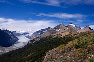
The Saskatchewan Glacier is located in Banff National Park, Alberta, Canada, approximately 120 km (75 mi) northwest of the town of Banff, and can be accessed from the Icefields Parkway. Saskatchewan Glacier is the largest outflow glacier from the Columbia Icefield, which rests along the Continental Divide. The glacier is a primary water source for the North Saskatchewan River. The glacier is approximately 13 kilometres (8.1 mi) long and covers an area of 30 km2 (11.5 mi2) and was measured in 1960 to be over 400 metres (1,310 ft) thick at a distance of 8 kilometres (5.0 mi) from the terminal snout. Between the years 1893 and 1953, Saskatchewan Glacier had receded a distance of 1,364 metres (4,475 ft), with the rate of retreat between the years 1948 and 1953 averaging 55 metres (180 ft) per year. The glacier, which flows northeast, exhibits a prominent medial morraine.

Devils Paw is the high point of the Juneau Icefield, on the Alaska-British Columbia border. It is a part of the Boundary Ranges of the Coast Mountains. It is notable for its steep rise above the low local terrain. Its height is sometimes given as 8,507 feet .

The Stikine Icecap is a large icefield straddled on the Alaska–British Columbia boundary in the Alaska Panhandle region. It lies in the Boundary Ranges of the Coast Mountains. Within the United States, most of it is under the administration of the Tongass National Forest and is part of the Stikine-LeConte Wilderness within the national forest.

Mount Callaghan is a volcanic peak located east of the headwaters of the Squamish River, just northeast of the Powder Mountain Icefield and just south of the Pemberton Icefield in the Sea to Sky Country of southwestern British Columbia, Canada, about 20 km directly west of the Resort Municipality of Whistler. A crack was observed across Callaghan's summit in the spring of 1999. In 2000, a section of the summit collapsed. Callaghan Lake lies below the south face of the mountain.

Mount Sarbach is a mountain located in Banff National Park between Mistaya River and Howse River and is visible from the Icefields Parkway. The mountain is named after Peter Sarbach, a mountain guide from Switzerland, who guided the first ascent by J. Norman Collie and G.P. Baker in 1897. Mount Sarbach is situated south of Saskatchewan River Crossing, where the Icefields Parkway intersects with the David Thompson Highway.
The Cambria Icefield is an icefield in the Boundary Ranges of the Coast Mountains in northwestern British Columbia, Canada, located southeast of Stewart.
Mamquam Mountain is a mountain in the Pacific Ranges of the Coast Mountains in southwestern British Columbia, Canada, located 6 km (3.7 mi) southeast of Eanastick Meadows and 22 km (14 mi) east of Brackendale. It represents the highest summit of the Mamquam Icefield and lies at the southern end of Garibaldi Provincial Park. Mamquam Mountain was named on September 2, 1930, in association with the Mamquam River.

Castleguard Mountain, also known as Mount Castleguard, is an isolated mountain located near the southern edge of the Columbia Icefield at the northern edge of Banff National Park in Alberta, Canada. In 1918, Irish land surveyor Arthur Oliver Wheeler named the mountain because of its castle-like appearance, which seemed to stand guard over the southern portion of the Columbia Icefield. Castleguard was first ascended in 1919 by the Interprovincial Boundary Commission, which determined the exact location of the boundary between British Columbia and Alberta along the continental divide.
