Whiteland, Indiana | |
---|---|
Coordinates: 39°32′41″N86°05′38″W / 39.54472°N 86.09389°W | |
Country | United States |
State | Indiana |
County | Johnson |
Township | Pleasant, Franklin, Clark |
Area | |
• Total | 5.49 sq mi (14.21 km2) |
• Land | 5.47 sq mi (14.17 km2) |
• Water | 0.01 sq mi (0.04 km2) |
Elevation | 794 ft (242 m) |
Population (2020) | |
• Total | 4,599 |
• Density | 840.46/sq mi (324.53/km2) |
Time zone | UTC-5 (Eastern (EST)) |
• Summer (DST) | UTC-4 (EDT) |
ZIP code | 46184 |
Area code | 317 |
FIPS code | 18-83816 [3] |
GNIS feature ID | 2397740 [2] |
Website | townofwhiteland |
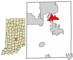
Whiteland is a town in Pleasant, Franklin and Clark townships, Johnson County, Indiana, United States. The population was 4,599 at the 2020 census.
Whiteland is located in north/central Johnson County approximately 19 miles (31 km) south of Indianapolis in Johnson County, which is one of the counties circling the capital city itself and therefore considered part of the Indianapolis metropolitan area. Major access roads to get to Whiteland are I-65 (exit 95 is the Whiteland exit), south on U.S. 31 from Indianapolis and north from Columbus.
Whiteland was platted in 1863 by Joel B. White and others. [4] The first school in the town was built in 1869, which was the only school in Whiteland until 1957, when a high school was built. [5]
According to the 2010 census, Whiteland has a total area of 3.22 square miles (8.34 km2), all land. [6]
The climate in this area is characterized by hot, humid summers and generally mild to cool winters. According to the Köppen Climate Classification system, Whiteland has a humid subtropical climate, abbreviated "Cfa" on climate maps. [7]
Census | Pop. | Note | %± |
---|---|---|---|
1880 | 230 | — | |
1890 | 212 | −7.8% | |
1900 | 334 | 57.5% | |
1910 | 343 | 2.7% | |
1920 | 388 | 13.1% | |
1930 | 419 | 8.0% | |
1940 | 403 | −3.8% | |
1950 | 465 | 15.4% | |
1960 | 1,368 | 194.2% | |
1970 | 1,492 | 9.1% | |
1980 | 1,956 | 31.1% | |
1990 | 2,446 | 25.1% | |
2000 | 3,958 | 61.8% | |
2010 | 4,169 | 5.3% | |
2020 | 4,599 | 10.3% | |
U.S. Decennial Census [8] |
As of the census [9] of 2010, there were 4,169 people, 1,468 households, and 1,163 families living in the town. The population density was 1,294.7 inhabitants per square mile (499.9/km2). There were 1,558 housing units at an average density of 483.9 per square mile (186.8/km2). The racial makeup of the town was 97.0% White, 0.4% African American, 0.2% Native American, 0.7% Asian, 0.1% Pacific Islander, 0.6% from other races, and 1.1% from two or more races. Hispanic or Latino of any race were 1.8% of the population.
There were 1,468 households, of which 41.4% had children under the age of 18 living with them, 64.2% were married couples living together, 9.5% had a female householder with no husband present, 5.6% had a male householder with no wife present, and 20.8% were non-families. 15.6% of all households were made up of individuals, and 4.8% had someone living alone who was 65 years of age or older. The average household size was 2.84 and the average family size was 3.15.
The median age in the town was 37.3 years. 27.6% of residents were under the age of 18; 8.2% were between the ages of 18 and 24; 27.1% were from 25 to 44; 28.5% were from 45 to 64; and 8.5% were 65 years of age or older. The gender makeup of the town was 49.1% male and 50.9% female.
As of the census [3] of 2000, there were 3,958 people, 1,355 households, and 1,116 families living in the town. The population density was 1,742.4 inhabitants per square mile (672.7/km2). There were 1,404 housing units at an average density of 618.1 per square mile (238.6/km2). The racial makeup of the town was 98.46% White, 0.05% African American, 0.10% Native American, 0.35% Asian, 0.56% from other races, and 0.48% from two or more races. Hispanic or Latino of any race were 1.09% of the population.
There were 1,355 households, out of which 47.8% had children under the age of 18 living with them, 70.6% were married couples living together, 9.3% had a female householder with no husband present, and 17.6% were non-families. 13.6% of all households were made up of individuals, and 4.6% had someone living alone who was 65 years of age or older. The average household size was 2.92 and the average family size was 3.23.
In the town, the population was spread out, with 32.2% under the age of 18, 6.2% from 18 to 24, 36.5% from 25 to 44, 18.4% from 45 to 64, and 6.7% who were 65 years of age or older. The median age was 33 years. For every 100 females, there were 98.6 males. For every 100 females age 18 and over, there were 95.1 males.
The median income for a household in the town was $56,944, and the median income for a family was $61,810. Males had a median income of $42,247 versus $29,005 for females. The per capita income for the town was $21,169. About 1.0% of families and 1.9% of the population were below the poverty line, including 2.6% of those under age 18 and none of those age 65 or over.
The first school in the town was built in 1869. This remained the only school in Whiteland, until 1957, when a high school was built. [5]
Chatom is a town in Washington County, Alabama, United States. It incorporated in 1949. Chatom is the county seat of Washington County, holding the distinction since 1907. The town's population was 1,288 At the 2010 census, up from 1,193 in 2000.
Corunna is a town in Richland Township, DeKalb County, Indiana, United States. The population was 236 at the 2020 census estimate.
Converse is a town in Jackson Township, Miami County, and Richland Township, Grant County, in the U.S. state of Indiana. The population was 1,161 at the 2020 census.
Newberry is a town in Cass Township, Greene County, Indiana, United States. The population was 193 at the 2010 census. It is part of the Bloomington, Indiana Metropolitan Statistical Area.
Worthington is a town in Jefferson Township, Greene County, Indiana, United States. The population was 1,463 at the 2010 United States Census. It is part of the Bloomington, Indiana, Metropolitan Statistical Area.
Coatesville is a town in Clay Township, Hendricks County, Indiana, United States. The population was 523 at the 2010 Census.
Warren is a town in Salamonie Township, Huntington County, Indiana. The population of Warren was 1,182 at the time of the 2020 census.
New Whiteland is a town in Pleasant Township, Johnson County, Indiana, United States. The population was 5,550 at the 2020 census.
Lawrence is a city in Marion County, Indiana, United States. It is one of four "excluded cities" in Marion County. The city is home to Fort Benjamin Harrison within Fort Harrison State Park. The population was 49,370 at the 2020 census. The city is on the northeast side of Indianapolis.
Rome City is a town in Orange Township, Noble County, in the U.S. state of Indiana. The population was 1,361 at the 2010 census.
Rockville is a town in Adams Township, Parke County, in the U.S. state of Indiana. The population was 2,607 at the 2010 census. The town is the county seat of Parke County. It is known as "The Covered Bridge Capital of the World".
Petersburg is a city within Washington Township and the county seat of Pike County, in the U.S. state of Indiana. The population was 2,304 at the 2020 census.
Poseyville is a town in Robb Township, Posey County, in the U.S. state of Indiana. The population was 1,045 at the 2010 census.
Lynn is a town in Washington Township, Randolph County, in the U.S. state of Indiana. The population was 1,097 at the 2010 census.
Sunman is a town in Adams Township, Ripley County, in the U.S. state of Indiana. The population was 1,049 at the 2010 census.
Morristown is a town in Hanover Township, Shelby County, in the U.S. state of Indiana. The population was 1,218 at the 2010 census.
Clear Lake is a town located in the northeast corner of Steuben County, Indiana, in Clear Lake Township. As such, is the northeasternmost community in the State of Indiana. The population was 339 at the 2010 census.
Marysville is a city in and the county seat of Marshall County, Kansas, United States. As of the 2020 census, the population of the city was 3,447.
Plains is a town in and the county seat of Yoakum County of western Texas, United States. The city's population was 1,355 at the 2020 census. Yoakum County is in the Texas High Plains Wine country.
Granville is a town in Monongalia County, West Virginia, United States. The population was 1,355 at the 2020 census. It is included in the Morgantown metropolitan area.