
The Cape Flats is an expansive, low-lying, flat area situated to the southeast of the central business district of Cape Town. The Cape Flats is also the name of an administrative region of the City of Cape Town, which lies within the larger geographical area.

Masiphumelele is a township on the Cape Peninsula, South Africa, situated between Kommetjie, Capri Village and Noordhoek.

Apartheid was a system of institutionalised racial oppression that existed in South Africa and South West Africa from 1948 until the early 1990s. This system denied non-white South Africans basic human rights, such as the right to vote. Apartheid was characterized by an authoritarian political culture based on baasskap, which ensured that South Africa was dominated politically, socially, and economically by the nation's minority white population. According to this system of social stratification, white citizens had the highest status, followed by Indians and Coloureds, then black Africans. The economic legacy and social effects of apartheid continue to the present day.

Khayelitsha is a township in Western Cape, South Africa, on the Cape Flats in the City of Cape Town Metropolitan Municipality. The name is Xhosa for New Home. It is reputed to be the largest and fastest-growing township in South Africa.
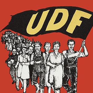
The United Democratic Front (UDF) was a South African popular front that existed from 1983 to 1991. The UDF comprised more than 400 public organizations including trade unions, students' unions, women's and parachurch organizations. The UDF's goal was to establish a "non-racial, united South Africa in which segregation is abolished and in which society is freed from institutional and systematic racism." Its slogan was "UDF Unites, Apartheid Divides." The Front was established in 1983 to oppose the introduction of the Tricameral Parliament by the white-dominated National Party government, and dissolved in 1991 during the early stages of the transition to democracy.

The City of Cape Town is the metropolitan municipality which governs the city of Cape Town, South Africa and its suburbs and exurbs. As of the 2011 census, it had a population of 3,740,026.

Gugulethu is a township in the Western Cape, South Africa and is 15 km from Cape Town. Its name is a contraction of igugu lethu, which is Xhosa for our pride. The township was established along with Nyanga in the 1960s.

Nyanga is a township in the Western Cape, South Africa. Its name in Xhosa means "moon" and it is one of the oldest black townships in Cape Town. It was established as a result of the migrant labour system. In 1948 black migrants were forced to settle in Nyanga as Langa had become too small. Nyanga was one of the poorest places in Cape Town and is still is one of the most dangerous parts of Cape Town. In 2001 its unemployment rate was estimated at being approximately 56% and HIV/AIDS is a huge community issue.

Manenberg is a township of Cape Town, South Africa, that was created by the apartheid government for low-income Coloured families in the Cape Flats in 1966 as a result of the forced removal campaign by the National Party. It has an estimated population of 52,000 residents. The area consists of rows of semi-detached houses and project-like flats, known as "korre". The township is located about 20 km away from the city centre of Cape Town. It is separated from neighbouring Nyanga and Gugulethu townships by a railway line to the east and from Hanover Park by the Sand Industria industrial park to the west and Heideveld to the north. The northern part of Manenberg has wealthy people that are mostly Muslims. The rest of Manenberg has poor people that are mostly associated with Christianity.

The Western Cape Anti-Eviction Campaign was a non-racial popular movement made up of poor and oppressed communities in Cape Town, South Africa. It was formed in November 2000 with the aim of fighting evictions, water cut-offs and poor health services, obtaining free electricity, securing decent housing, and opposing police brutality.
Ivan Toms was a South African physician, who battled the Apartheid era government as a prominent anti-Apartheid and anti-conscription activist. At the time of his death in 2008, Toms was serving as the Director of Health for the city of Cape Town, South Africa.
Prior to 1994, immigrants from elsewhere faced discrimination and even violence in South Africa. After majority rule in 1994, contrary to expectations, the incidence of xenophobia increased. Between 2000 and March 2008, at least 67 people died in what were identified as xenophobic attacks. In May 2008, a series of attacks left 62 people dead; although 21 of those killed were South African citizens. The attacks were motivated by xenophobia. In 2015, another nationwide spike in xenophobic attacks against immigrants in general prompted a number of foreign governments to begin repatriating their citizens. A Pew Research poll conducted in 2018 showed that 62% of South Africans viewed immigrants as a burden on society by taking jobs and social benefits and that 61% of South Africans thought that immigrants were more responsible for crime than other groups. Between 2010 and 2017 the immigrant community in South Africa increased from 2 million people to 4 million people. The proportion of South Africa's total population that is foreign born increased from 2.8% in 2005 to 7% in 2019, according to the United Nations International Organization for Migration, in spite of widespread xenophobia in the country. This made South Africa the largest recipient of immigrants on the African continent in 2019.

Philippi is a large urban and semi-urban area in Cape Town's Cape Flats region, in the Western Cape, South Africa. It comprises the Philippi Horticultural Area to the west, and the neighbourhoods of Brown's Farm, Philippi East and Samora Machel located within its eastern half. The neighbourhoods of Gugulethu and Nyanga are located to its north. The horticultural area is sparsely populated compared to the surrounding city and contains many farms.
Trust Feed is a small rural town in Umgungundlovu District Municipality in the KwaZulu-Natal province of South Africa.
Mkhuseli "Khusta" Jack was a South African Anti-Apartheid activist in the 1980s, known for his involvement in the Anti-Apartheid struggle and his efforts in the Consumer Boycott Campaign. Currently he is a businessman in Port Elizabeth, South Africa.

There have been pride parades in South Africa celebrating LGBT pride since 1990. South African pride parades were historically used for political advocacy protesting against legal discrimination against LGBT people, and for the celebration of equality before the law after the apartheid era. They are increasingly used for political advocacy against LGBT hate crimes, such as the so-called corrective rape of lesbians in townships, and to remember victims thereof.
Oscar Mafakafaka Mpetha was born in Mount Fletcher 5 August 1909 and died on 15 November 1994. He was a South African trade unionist and political activist.
The Cradock Four were a group of four anti-apartheid activists who were abducted and murdered by South African security police in June 1985, named as such as all four were from the town of Cradock, Eastern Cape. The South African apartheid government denied that they had ordered the killings, but a document leaked to the press years later resulted in the removal of several police officers. At the second inquest, a judge ruled that the "security forces" were responsible, but named no one individual.
Fezeka High School is a public high school located in Gugulethu, Western Cape, South Africa. It is one of the high schools in the City of Cape Town Metropolitan Municipality.


