
Hook of Holland is a town in the southwestern corner of Holland, hence the name; hoek means "corner" and was the word in use before the word kaap – "cape", from Portuguese cabo – became Dutch. The English translation using Hook is a false cognate of the Dutch Hoek, but has become commonplace. It is located at the mouth of the New Waterway shipping canal into the North Sea. The town is administered by the municipality of Rotterdam as a district of that city. Its district covers an area of 16.7 km2, of which 13.92 km2 is land. On 1 January 1999 it had an estimated population of 9,400.

Bodegraven is a town and former municipality in the western Netherlands, in the province of South Holland. The former municipality covers an area of 38.50 km2 (14.86 sq mi) of which 1.02 km2 (0.39 sq mi) is water.

The Two Oceans Marathon is a 56 km / 35-mile ultramarathon and 21 km half-marathon held annually in Cape Town, South Africa on the Saturday of the Easter weekend.

Seven Hills is a suburb in the Greater Western Sydney region of Sydney, in the state of New South Wales, Australia, located 33 kilometres North West of the Sydney central business district. Seven Hills is within the local government areas of the City of Parramatta and Blacktown City councils.
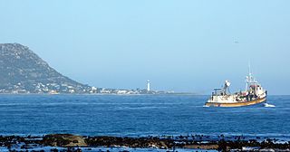
Kommetjie is a small town near Cape Town, in the Western Cape province of South Africa. It lies about halfway down the west coast of the Cape Peninsula, at the southern end of the long wide beach that runs northwards towards Chapman's Peak and Noordhoek. The community of Ocean View is located to its immediate south east.

The Cape Peninsula is a generally mountainous peninsula that juts out into the Atlantic Ocean at the south-western extremity of the African continent. At the southern end of the peninsula are Cape Point and the Cape of Good Hope. On the northern end is Table Mountain, overlooking Table Bay and the city bowl of Cape Town, South Africa. The peninsula is 52 km long from Mouille point in the north to Cape Point in the south. The Peninsula has been an island on and off for the past 5 million years, as sea levels fell and rose with the ice age and interglacial global warming cycles of, particularly, the Pleistocene. The last time that the Peninsula was an island was about 1.5 million years ago. Soon afterwards it was joined to the mainland by the emergence from the sea of the sandy area now known as the Cape Flats. The towns and villages of the Cape Peninsula and Cape Flats, and the undeveloped land of the rest of the peninsula now form part of the City of Cape Town metropolitan municipality. The Cape Peninsula is bounded to the north by Table Bay, to the west by the open Atlantic Ocean, and to the east by False Bay in the south and the Cape Flats in the north.

Loxley is a village and a suburb of the city of Sheffield, England. It is a long linear community which stretches by the side of the River Loxley and along the B6077 for almost 2.5 miles (4 km). Loxley extends from its borders with the suburbs of Malin Bridge and Wisewood westward to the hamlet of Stacey Bank near Damflask Reservoir. The centre of the suburb is situated at the junction of Rodney Hill and Loxley Road where the old village green stands and this is located 3 miles (5 km) north west of Sheffield city centre. The suburb falls within the Stannington ward of the City of Sheffield.

Fish Hoek is a coastal town at the eastern end of the Fish Hoek Valley on the False Bay side of the Cape Peninsula in the Western Cape, South Africa. Previously a separate municipality, Fish Hoek is now part of the City of Cape Town. As a coastal suburb of Cape Town, Fish Hoek is popular as a residence for commuters, retired people and holidaymakers alike. The traditional industries of 'trek' fishing and angling coexist with the leisure pursuits of surfing, although nearby Kommetjie is usually favoured, sailing and sunbathing. There is an active lifeguard community who utilise the beach and bay for training.

Noordhoek is a seaside town in the Western Cape, South Africa, located below Chapman's Peak on the west coast of the Cape Peninsula and is approximately 35 kilometres (22 mi) to the south of Cape Town. The name "Noordhoek" was taken from Dutch and literally means "north corner". It was given this name in 1743 as being the northern corner of the Slangkop farm. The first permanent resident of European origin is Jaco Malan who built his house there. In 1857, the region was divided into six plots, most of which were bought by a single family, that of the de Villiers. Noordhoek nevertheless remains a predominantly rural area where farmers grow vegetables to supply ships calling at Simon's Town. It is best known for its shoreline and its long, wide, sandy beach, which stretches south to the neighbouring village of Kommetjie. Near the southern end of this beach is the wreck of the steamship "Kakapo", which ran aground in 1900, when the captain mistook Chapman's Peak for the Cape of Good Hope and put the helm over to port.

Wynberg is a southern suburb of the City of Cape Town in Western Cape, South Africa. It is situated between Plumstead and Kenilworth, and is a main transport hub for the Southern Suburbs of Cape Town.

The M3 is an expressway in Cape Town, South Africa, connecting the upper part of the City Bowl to the Southern Suburbs and ending in Tokai. For most of its route it parallels - though further to the south and west - the M4, which was the original road connecting central Cape Town with the settlements to the south.

Brackenfell is a railway town in the Western Cape province of South Africa at the gateway to the Cape Winelands. Formerly an independent municipality, Brackenfell is now a part of the City of Cape Town Metropolitan Municipality and is about 30 kilometres (19 mi) east of Cape Town City Bowl. In Brackenfell a variety of property situated on the slopes of the Bottelary Hills can be found.

Durbanville is a town in the Western Cape province of South Africa, part of the greater Cape Town metropolitan area. Durbanville is a semi-rural residential suburb on the north-eastern outskirts of the metropolis and is surrounded by farms producing wine and wheat.
The Cape Town Cycle Tour is an annual cycle race hosted in Cape Town, South Africa, usually 109 km (68 mi) long. It is the first event outside Europe to be included in the Union Cycliste Internationale's Golden Bike Series. South Africa hosts some of the largest, by the number of entrants, sporting events in the world with three being the largest of their type. The Cape Town Cycle Tour, with as many as 35 000 cyclists taking part, is the world's largest individually timed cycle race. The other two are the world's largest ultra-marathon running event, the Comrades Marathon, and the world's largest open water swim, the Midmar Mile.

The Southern Suburbs are a group of Anglophone suburbs in Cape Town, Western Cape, South Africa. This group includes, among others, Observatory, Mowbray, Pinelands, Rosebank, Rondebosch, Rondebosch East, Newlands, Claremont, Hanover Park,Lansdowne, Kenilworth, Bishopscourt, Constantia, Wynberg, Ottery, Plumstead, Diep River, Bergvliet and Tokai. The area is also commonly referred to as the Cape Peninsula, often including the towns further South such as Fish Hoek.
Capri Village is a small suburb forming part of the greater area of Noordhoek on the Cape Peninsula, South Africa, situated between Kommetjie, De Oude Weg, Fish Hoek and Noordhoek.
Claremont is a suburb of Cape Town, South Africa. It is situated 9 kilometres south of the city, and is one of the so-called "Southern Suburbs", it is situated alongside Lansdowne. It is an important commercial and residential area, which is currently experiencing significant growth and development.

Constantia Nek is a low pass over the Table Mountain range in Cape Town, South Africa, linking Constantia to Hout Bay in the west. It is one of three passes connecting Hout Bay to the rest of the city, and, with Ou Kaapse Weg is one of the two passes over the mountain range between the city centre and the Fish Hoek valley.
The Fish Hoek Valley is situated in the Cape Peninsula, eighteen miles south of Cape Town, South Africa. It takes its name from the town of Fish Hoek on the False Bay coast.

Ou Kaapse Weg, numbered as route M64, is a mountain pass in the Cape Peninsula that connects the Southern Suburbs of Cape Town with the Fish Hoek Valley. It traverses the Steenberg mountains and passes through the Silvermine Nature Reserve. Ou Kaapse Weg is one of three routes to the Fish Hoek Valley: the others are Chapman's Peak Drive along the Atlantic coast and Main Road along the False Bay coast. Despite its name, the pass was only constructed in 1968, by the Divisional Council of the Cape.

