1940 United States presidential election in Montana

Last updated

1940 United States presidential election in Montana
Flag of Montana (1905-1981).svg
  1936 November 5, 1940 1944  
  FDRoosevelt1938.jpg WendellWillkie.png
Nominee Franklin D. Roosevelt Wendell Willkie
Party Democratic Republican
Home state New York New York
Running mate Henry A. Wallace Charles L. McNary
Electoral vote40
Popular vote145,69899,579
Percentage58.78%40.17%

Montana Presidential Election Results 1940.svg
County results

President before election

Franklin D. Roosevelt
Democratic

Elected President

Franklin D. Roosevelt
Democratic

The 1940 United States presidential election in Montana took place on November 5, 1940, as part of the 1940 United States presidential election. Voters chose four representatives, or electors to the Electoral College, who voted for president and vice president.

Contents

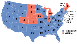
Montana voted powerfully to give Democratic nominee, President Franklin D. Roosevelt an unprecedented third term, over the Republican nominee, corporate lawyer Wendell Willkie, a dark horse candidate that had never before run for a political office. Roosevelt won Montana by a convincing 18.61% margin. As of the 2024 presidential election , this remains the last election in which the following counties have voted for a Democratic presidential nominee: Broadwater, Madison, Meagher and Garfield. [1]

Results

1940 United States presidential election in Montana [2]
PartyCandidateVotesPercentageElectoral votes
Democratic Franklin D. Roosevelt (incumbent)145,69858.78%4
Republican Wendell Willkie 99,57940.17%0
Socialist Norman Thomas 1,4430.58%0
Prohibition Roger Babson 6640.27%0
Communist Earl Browder 4890.20%0
Totals247,783100.00%4

Results by county

CountyFranklin Delano Roosevelt
Democratic
Wendell Lewis Willkie
Republican
Various candidates
Other parties
MarginTotal votes cast [3]
#%#%#%#%
Beaverhead 1,63248.41%1,72551.17%140.42%-93-2.76%3,371
Big Horn 1,92654.10%1,61645.39%180.51%3108.71%3,560
Blaine 2,12963.99%1,16535.02%330.99%96428.98%3,327
Broadwater 85452.94%75546.81%40.25%996.14%1,613
Carbon 2,67851.89%2,42146.91%621.20%2574.98%5,161
Carter 73456.81%55643.03%20.15%17813.78%1,292
Cascade 13,63767.10%6,44331.70%2441.20%7,19435.40%20,324
Chouteau 2,21363.68%1,23535.54%270.78%97828.14%3,475
Custer 2,78257.55%2,01741.73%350.72%76515.83%4,834
Daniels 1,08656.53%80742.01%281.46%27914.52%1,921
Dawson 1,76552.03%1,61247.52%150.44%1534.51%3,392
Deer Lodge 4,91666.93%2,39732.63%320.44%2,51934.30%7,345
Fallon 68642.24%92556.96%130.80%-239-14.72%1,624
Fergus 3,87358.51%2,70640.88%400.60%1,16717.63%6,619
Flathead 5,12752.96%4,40345.48%1511.56%7247.48%9,681
Gallatin 4,71857.55%3,43041.84%500.61%1,28815.71%8,198
Garfield 64450.67%62549.17%20.16%191.49%1,271
Glacier 2,39963.80%1,35235.96%90.24%1,04727.85%3,760
Golden Valley 35146.25%40252.96%60.79%-51-6.72%759
Granite 91753.63%78445.85%90.53%1337.78%1,710
Hill 3,70065.87%1,84232.79%751.34%1,85833.08%5,617
Jefferson 1,25960.04%83039.58%80.38%42920.46%2,097
Judith Basin 1,21563.51%67035.02%281.46%54528.49%1,913
Lake 2,37945.92%2,71852.46%841.62%-339-6.54%5,181
Lewis and Clark 5,81454.42%4,76244.58%1071.00%1,0529.85%10,683
Liberty 55055.33%43443.66%101.01%11611.67%994
Lincoln 2,15062.35%1,25036.25%481.39%90026.10%3,448
Madison 1,67451.41%1,55747.82%250.77%1173.59%3,256
McCone 92861.83%52935.24%442.93%39926.58%1,501
Meagher 62153.67%52044.94%161.38%1018.73%1,157
Mineral 64560.39%40237.64%211.97%24322.75%1,068
Missoula 7,74757.23%5,64041.66%1501.11%2,10715.56%13,537
Musselshell 1,80761.21%1,08636.79%592.00%72124.42%2,952
Park 2,83353.26%2,43345.74%531.00%4007.52%5,319
Petroleum 31650.08%31349.60%20.32%30.48%631
Phillips 2,22566.10%1,11032.98%310.92%1,11533.13%3,366
Pondera 1,89963.72%1,03834.83%431.44%86128.89%2,980
Powder River 56146.29%63352.23%181.49%-72-5.94%1,212
Powell 1,76560.82%1,11638.46%210.72%64922.36%2,902
Prairie 55447.72%59751.42%100.86%-43-3.70%1,161
Ravalli 2,77352.19%2,48346.73%571.07%2905.46%5,313
Richland 2,09557.48%1,49741.07%531.45%59816.41%3,645
Roosevelt 2,41860.72%1,50337.74%611.53%91522.98%3,982
Rosebud 1,39952.26%1,25246.77%260.97%1475.49%2,677
Sanders 1,63458.48%1,08838.94%722.58%54619.54%2,794
Sheridan 2,10869.07%89229.23%521.70%1,21639.84%3,052
Silver Bow 17,46767.88%7,93230.82%3351.30%9,53537.05%25,734
Stillwater 1,20148.53%1,25550.71%190.77%-54-2.18%2,475
Sweet Grass 74146.00%86153.45%90.56%-120-7.45%1,611
Teton 1,73559.95%1,13239.12%270.93%60320.84%2,894
Toole 1,95461.41%1,21838.28%100.31%73623.13%3,182
Treasure 32152.62%28747.05%20.33%345.57%610
Valley 3,49367.67%1,59730.94%721.39%1,89636.73%5,162
Wheatland 94854.42%78645.12%80.46%1629.30%1,742
Wibaux 57655.23%46144.20%60.58%11511.03%1,043
Yellowstone 9,03651.18%8,47948.03%1400.79%5573.15%17,655
Totals145,60858.76%99,57940.19%2,5961.05%46,02918.58%247,783

Counties that flipped from Democratic to Republican

See also

References

  1. Sullivan, Robert David; ‘How the Red and Blue Map Evolved Over the Past Century’; America Magazine in The National Catholic Review; June 29, 2016
  2. David Leip. "1940 Presidential General Election Results – Montana". Dave Leip’s U.S. Election Atlas.
  3. Scammon, Richard M. (compiler); America at the Polls: A Handbook of Presidential Election Statistics 1920-1964; p. 271 ISBN   0405077114