Mainahar Katra is a village in Bachhrawan block of Rae Bareli district, Uttar Pradesh, India. As of 2011, its population is 2,197, in 382 households. It historically formed a taluqdar estate.
Saidpur Behta is a village in Bachhrawan block of Rae Bareli district, Uttar Pradesh, India. As of 2011, its population is 612, in 118households. It historically belonged to the taluqdars of Tirbediganj.
Deopuri, also spelled Devpuri, is a village in Bachhrawan block of Rae Bareli district, Uttar Pradesh, India. As of 2011, its population is 1,188, in 244 households. Located 2 km from Bachhrawan, Deopuri was historically the last village held by the zamindars descended from Qazi Sultan, the first zamindar of the pargana of Thulendi in the 1400s.
Karanpur is a village in Bachhrawan block of Rae Bareli district, Uttar Pradesh, India. Located 23 km from the city of Raebareli, Karanpur was historically one of the main villages in the Bachhrawan pargana. As of 2011, Karanpur's population is 4,171, in 791 households.

Johwa Sharki, also spelled Sharqi, is a village in Harchandpur block of Rae Bareli district, Uttar Pradesh, India. It is an especially large village with many hamlets spread out over a wide area. It lies a bit to the north of the river Sai, between the road from Bachhrawan to Lalganj on one side and the railway on the other. As of 2011, its population is 10,657, in 2,027 households. It has 4 primary schools and no healthcare facilities.
Kathwara is a village in Harchandpur block of Rae Bareli district, Uttar Pradesh, India. It is located 13km from Raebareli, the district headquarters, on the road to Lucknow, and on the left bank of the Baita river not far from its confluence with the Sai. The railway passes by Kathwara, and the closest station is at Harchandpur. As of 2011, the population of Kathwara is 5,115, in 921 households. It has two primary schools and no healthcare facilities.

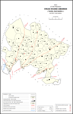
Pahremau is a village in Amawan block of Rae Bareli district, Uttar Pradesh, India. Located 5 km from Maharajganj on the road to Nigohan, it is an old Muslim centre that historically served as the headquarters of a taluqdari estate. As of 2011, its population is 3,165, in 577 households. It has 3 primary schools and no healthcare facilities.
Kondras Buzurg is a village in Amawan block of Rae Bareli district, Uttar Pradesh, India. It is located 9 km from Raebareli, the district headquarters. As of 2011, its population is 3,143, in 581 households. It has two primary schools and no healthcare facilities.

Ataura Buzurg is a village in Sataon block of Rae Bareli district, Uttar Pradesh, India. It is located 14 km from Raebareli, the district headquarters. As of 2011, its population is 8,466, in 1,573 households. It has 4 primary schools and no healthcare facilities.
Kilauli is a village in Sataon block of Rae Bareli district, Uttar Pradesh, India. It is located 8 km from Raebareli, the district headquarters. As of 2011, its population is 5,188, in 1,045 households. It has 6 primary schools and no healthcare facilities.

Rahi is a village and corresponding community development block in Rae Bareli district, Uttar Pradesh, India. It is located 7 km from Rae Bareli, the district headquarters, which according to one folk etymology is named after the village. Rahi was formerly the seat of a pargana before Rae Bareli replaced it in that capacity. As of 2011, Rahi has a population of 7,536 people, in 1,373 households. It has one primary school and one medical clinic.
Lodhwari is a village in Rahi block of Rae Bareli district, Uttar Pradesh, India. It is located 12 km from Rae Bareli, the district headquarters, on the left bank of the Sai river. The road to Parshadepur runs through the northeastern part of the village lands. As of 2011, Lodhwari has a population of 10,592 people, in 2,019 households.

Bahai is a village in Lalganj block of Rae Bareli district, Uttar Pradesh, India. It is located 8 km from Lalganj, the block and tehsil headquarters, to the east of the road to Dalmau. It is on high ground and is drained by two large streams that merge together further south before joining the Ganges.
Behta Kalan is a village in Lalganj block of Rae Bareli district, Uttar Pradesh, India. It is located 8 km (5.0 mi) from Lalganj, the block and tehsil headquarters, a bit to the north of the road connecting it and Rae Bareli, the district headquarters.

Tonk is a village in Dalmau block of Rae Bareli district, Uttar Pradesh, India. It is located 10 km from Dalmau, the block headquarters. As of 2011, it has a population of 642 people, in 120 households. It has no schools and no healthcare facilities.
Barara Buzurg is a village in Dalmau block of Rae Bareli district, Uttar Pradesh, India. It is located 8 km (5.0 mi) from Dalmau, the block headquarters. As of 2011, it has a population of 5,685 people, in 1,031 households. It has 4 primary schools and 1 maternity and child welfare centre. It hosts a market twice per week, on Mondays and Fridays; cattle, cloth, and vegetables are the main items traded.

Gaura Hardo, or just Gaura, is a village in Rae Bareli district, Uttar Pradesh, India. It serves as the headquarters of Deenshah Gaura block, in the tehsil of Dalmau. It is located 33 km from Raebareli, the district headquarters, on the road from Dalmau to Salon. As of 2011, Gaura Hardo has a population of 8,001 people, in 1,446 households. It has five primary schools and one maternity and child welfare centre.

Rasulpur is a village in Rohaniya block of Rae Bareli district, Uttar Pradesh, India. One of the largest villages in the historical pargana of Salon, it is located 48 km from Raebareli, the district headquarters. As of 2011, it has a population of 7,671 people, in 1,379 households. It has one primary school and no healthcare facilities.
Itaura Buzurg is a village in Rohaniya block of Rae Bareli district, Uttar Pradesh, India. One of the largest villages in the historical pargana of Salon, it is located 28 km from Raebareli, the district headquarters, near the point where the road to Allahabad intersects the one leading from Fursatganj to the Gukana ghat. As of 2011, Itaura Buzurg has a population of 13,851 people, in 2,469 households. It has 6 primary schools and no healthcare facilities.
Aihari Buzurg is a village in Rohaniya block of Rae Bareli district, Uttar Pradesh, India. It is located 32 km from Raebareli, the district headquarters. As of 2011, it has a population of 1,101 people, in 192 households. It has one primary school and no healthcare facilities, and does not host a permanent market or a weekly haat.