Tiloi

Last updated

Tiloi
Tīloi
Town
Tiloi block map.png
Map of Tiloi CD block
India Uttar Pradesh location map.svg
Red pog.svg
Tiloi
Location in Uttar Pradesh, India
Coordinates: 26°23′34″N81°28′33″E / 26.392714°N 81.475942°E / 26.392714; 81.475942 [1]
CountryFlag of India.svg  India
State Uttar Pradesh
District Amethi
Area
[2]
  Total5.35 km2 (2.07 sq mi)
Population
 (2011) [2]
  Total6,956
  Density1,300/km2 (3,400/sq mi)
Languages
  Official Hindi
Time zone UTC+5:30 (IST)
PIN
229308 [2]
Vehicle registration UP-35

Tiloi is a town and tehsil headquarters in Amethi district of Uttar Pradesh, India. [2] Located near Mohanganj on the Jais-Inhauna road, Tiloi is notable as the historical seat of a major taluqdari estate held by the Kanhpurias. [3] As of 2011, its population was 6,956, in 1,257 households. [2]

Contents

Tiloi hosts a Ramlila festival annually on Dussehra, involving a dramatic reenactment of the Ramayana. [4]

History

Tiloi was historically the seat of a large taluqdari estate held by a branch of the Kanhpuria Rajputs. [3] At the turn of the 20th century, Tiloi was the second-largest taluqa in Raebareli district, after Khajurgaon. [3] The Kanhpurias of Tiloi were descendants of Rahas, one of the two sons of the eponymous founder Kanh (the other branch, descended from his brother Sahas, was mostly based in what is now Pratapgarh district). [3] Five generations after Rahas was Parshad Singh, who divided his lands among his three sons. [3] The oldest, Janga Singh, was based at Tiloi and ruled over what was then the entire pargana of Jais. [3] (This corresponds with the later parganas of Rokha-Jais, Simrauta, Mohanganj, and Gaura-Jamun in what is now Sultanpur district.) [3] Janga Singh's brothers were based at Ateha and Simrauta respectively. [3]

The Tiloi estate was first divided upon the death of Janga Singh's grandson, Jagdis Rai. [3] His younger son, Indrajit, inherited the territory of Gaura-Jamun and was the ancestor of several branches of the dynasty including the rajas of Katari and taluqdars of Jamun, Raisi, Baraulia, and Bhawan-Shahpur. [3] Jagdis Rai's elder son, Mitrajit, kept Tiloi. [3] His son, Kandhe Rai, unsuccessfully attacked the Pathans of Pahremau. [3] Kandhe Rai's two sons, Udebhan and Gulal Sah, again divided the estate, with Udebhan receiving Tiloi and Gulal Sah receiving Shahmau. [3] During Udebhan's reign, the Kurmis took up arms against the Kanhpurias and were not defeated until after his death. [3]

Surat Singh, who was blind and succeeded Udebhan as raja of Tiloi sometime between 1670 and 1680, was an energetic ruler who "thoroughly established his position as head of the entire clan". [3] He finally defeated the Kurmis and supposedly came to rule over 14 parganas. [3] He came into conflict with the Sombansis of Pratapgarh district, but was defeated in battle by them at Hindaur. [3] Surat Singh's successor, Gopal Singh, had a relatively unremarkable reign. [3] He favoured his younger son, Niwal Singh, which outraged his older son, the one-eyed Mohan Singh, so much that he had Gopal Singh murdered and installed himself on the Tiloi throne by force. [3] Mohan Singh was another energetic ruler who went on several military campaigns and lived to an old age before dying in 1743. [3]

Mohan Singh's son Pem Singh ruled for only five years and died in 1748. [3] His son Balbhaddar Singh, though, was a renowned warrior who joined forces with the Mughals against the Marathas and was given a mansab of 5,000, becoming one of the highest-ranking Awadhi grandees at the imperial court. [3] Balbhaddar Singh eventually died in battle while rebelling against the Nawab of Awadh; as he was childless, one of his widows invested Chhatardhari Singh of Shahmau as the next raja of Tiloi, but this was contested by the rest of the Kanhpurias. [3] Another widow of Balbhaddar Singh adopted Shankar Singh of Asni as heir to the Tiloi throne, and a 15-year-long war of succession followed. [3] This was eventually resolved by a compromise where both claimants received the title of Raja, but neither was given the throne of Tiloi. [3] However, Shankar Singh later gained control of Tiloi through peaceful means. [3]

The messy succession meant that the Tiloi estate had become broken up, and Shankar Singh's successor Bunyad Singh inherited "only a fraction" of the large territory once held by Balbhaddar Singh. [3] His adopted nephew Raja Jagpal Singh at first joined the Indian Rebellion of 1857 but later switched sides and joined the British, and was later rewarded with a large grant of confiscated lands. [3] The hereditary title of Raja was confirmed by the British in 1877, and then in 1882 this was further elaborated to Raja Bahadur. [3]

At the turn of the 20th century, Tiloi was described as a market village whose importance mainly derived from its status as the estate capital. [3] The market was small but of some significance, and it was held twice per week on Wednesdays and Sundays. [3] There was also a primary school and the taluqdar's residence. [3] Its population in 1901 was 2,768 people, including 359 Muslims and a fair number of Banias. [3]

The 1961 census recorded Tiloi (as "Teoli") as comprising 16 hamlets, with a total population of 2,205 people (1,070 male and 1,136 female), in 492 households and 481 physical houses. [4] The area of the village was given as 1,366 acres. [4] It had a medical practitioner and a post office at that time, as well as a government-run dispensary. [4] The S.P.N. Higher Secondary School in Tiloi, founded in 1953, had in 1961 a faculty of 14 teachers (all male) and a student body of 341 males and 9 females. [4] Average attendance of the biweekly market was given as about 1,000 people at the time, while attendance of the annual Ramlila festival was about 15,000. [4]

The 1981 census recorded Tiloi as having a population of 3,682 people, in 874 households, and having an area of 552.41 hectares. [5]

Villages

Tiloi CD block has the following 83 villages: [2]

Village nameTotal land area (hectares)Population (in 2011)
Thokarpur 303.52,707
Maheshpur 43.199
Semrauta 617.26,243
Pure Laximan Dei 28.6228
Basantpur 311.51,990
Rajapur Halim 3671,469
Satgawan 292.62,747
Ambarpur Farsi 289.22,188
Ramnagar 166.91,389
Kisunpur 63.6374
Pure Baheliya 76.8478
Kamae 630.53,816
Chingahi 736.61,768
Bhadmar 288.72,038
Revata Deeh 90.3671
Biraj 559.43,716
Bhadsana 426.21,862
Ashapur Gari 295.42,026
Kotwa 225.61,544
Saidpur 103.1474
Karaunka 96.4378
Pure Dwandi 203.8518
Sijni 2721,210
Ondeeh 2722,115
Alaipur 393.91,632
Chhichha 283.2996
Besarwa 216.41,484
Pure Manimanohar 133.5959
Pure Manga 57.2294
Baghauna 260.31,291
Uttarpara 189.41,263
Chaura 67.4507
Rajwapur 86.6191
Dhanhuwa 72.4349
Satwa 93.6743
Ramae 395.12,529
Pakar Gaon 1,054.56,266
Chetra Khurd 105.3384
Chetra Bujurg 426.83,836
Bardharme 195.3960
Saimbasi 472.52,420
Sangrampur 180.41,053
Barkot 373.32,428
Savitapur 158.8849
Pashchim Tiloi 166.31,042
Devkali 242.41,127
Tiloi (block headquarters)5356,956
Sangipur 98742
Ashapur Ruru 132.83,477
Bhelai Khurd 189.9736
Bhelai Kalan 220.43,120
Kutmara 113.71,026
Rajanpur 88.21,052
Lodhwariya 181.22,073
Ariyawan 177.92,437
Saraiya 139.1747
Nasaratpur 1781,069
Kamapur 64.6570
Chathuwa 334.53,482
Marhauna 3423,530
Khanapur Ban 133.2781
Rajamau 256.52,171
Garehari 458.43,085
Jagdishpur 41.4435
Jamurwa 672.14,533
Murtajapur 63.9436
Todarpur 77.4533
Hanswa 3942,326
Asni 241.92,244
Dhorhanpur 447.83,586
Lihi 271.91,618
Ahuri 741.14,606
Meera Mau 212.11,350
Berara 270.42,195
Koora 912.44,722
Narayanpur 133.2467
Shah Mau 144.41,647
Balapur 111.5437
Janapur 249.52,221
Agauna 442.32,478
Bhagirathpur 302.12,743
Tama Mau 148.31,577
Belwa Hasanpur 4002,224

Related Research Articles

<span class="mw-page-title-main">Maharajganj, Raebareli</span> Nagar panchayat in Uttar Pradesh, India

Maharajganj is a town and nagar panchayat in Rae Bareli district, Uttar Pradesh, India. It serves as the headquarters of a tehsil. As of 2011, its population is 6,673, in 1,037 households.

<span class="mw-page-title-main">Kumhrawan</span> Village in Uttar Pradesh, India

Kumhrawan is a village in Shivgarh block of Rae Bareli district, Uttar Pradesh, India. Formerly a pargana headquarters, it consists of a main village and several scattered hamlets. As of 2011, Kumhrawan has a population of 2,441, in 426 households.

<span class="mw-page-title-main">Chandapur, Raebareli</span> Village in Uttar Pradesh, India

Chandapur is a village in Maharajganj block of Rae Bareli district, Uttar Pradesh, India. Located 4 miles (6.4 km) east of Maharajganj, the block headquarters, it historically was the seat of the Kanhpuria rajas of Chandapur. In 2011, Chandapur had a population of 2,342, in 425 households. It has two primary schools and no healthcare facilities. It has a bazar known as Sheodarshanganj, which holds markets twice per week. The village also hosts the Anna Purna Devi fair on Phalguna Badi 13, which is associated with Maha Shivaratri. Vendors bring sweets, toys and everyday items to sell at the fair.

<span class="mw-page-title-main">Shahmau</span> Village in Uttar Pradesh, India

Shahmau is a village panchayat in Tiloi block of district Amethi, Uttar Pradesh, India. It is located 22 km (14 mi) from Gauriganj the district headquarters Amethi, on the road from Mohanganj to Jais. Historically, Shahmau was the taluqdari held by a branch of the Kanhpuria Kshatriya (Rajput), the Ruler taluqdars bore the hereditary title of Raja. As of 2011, its population is 1,647, in 286 households.

<span class="mw-page-title-main">Panhauna</span> Village in Uttar Pradesh, India

Panhauna is a village in Singhpur block of Rae Bareli district, Uttar Pradesh, India. As of 2011, its population is 7,075, in 1,307 households. It has one primary school and no healthcare facilities.

<span class="mw-page-title-main">Amawan</span> Village in Uttar Pradesh, India

Amawan is a village and corresponding community development block in Rae Bareli district, Uttar Pradesh, India. It historically was the seat of a taluqdari estate held by a Pathan family and eventually split into two shares. As of 2011, its population is 5,245, in 973 households. It has 5 primary schools and no healthcare facilities.

<span class="mw-page-title-main">Simrauta</span> Village in Uttar Pradesh, India

Semrauta is a village in Tiloi block of Rae Bareli district, Uttar Pradesh, India. It is located at the intersection of the Maharajganj-Inhauna and Mohanganj-Haidargarh roads, about 20 km from Maharajganj, the tehsil headquarters. Although now eclipsed by Maharajganj, Semrauta was historically a relatively important village that served as the headquarters of a pargana and the capital of a branch of the Kanhpuria Rajputs, who later became known as the Rajas of Chandapur. As of 2011, the population of Simrauta is 6,423, in 1,031 households.

<span class="mw-page-title-main">Hardaspur, Raebareli</span> Village in Uttar Pradesh, India

Hardaspur is a village in Amawan block of Rae Bareli district, Uttar Pradesh, India. As of 2011, its population is 2,974, in 570 households. It has 3 primary schools and one small clinic.

<span class="mw-page-title-main">Korihar</span> Village in Uttar Pradesh, India

Korihar is a village located in Sataon block of Rae Bareli district, Uttar Pradesh, India. Located 20 km from Raebareli, the district headquarters, Korihar was historically the seat of a taluqdari estate held by a branch of the Bais Rajputs. On the northwest is Sataon, and to the south is the village of Hajipur, which has the ruins of an old Bais fort. As of 2011, the population of Korihar is 12,351, in 2,240 households. It has one primary school and no healthcare facilities. The village hosts markets twice per week, on Mondays and Fridays.

<span class="mw-page-title-main">Murarmau</span> Village in Uttar Pradesh, India

Murarmau is a village in Sareni block of Rae Bareli district, Uttar Pradesh, India. It is located 21 km from Lalganj, the tehsil headquarters. Murarmau historically served as the seat of the largest taluqdar estate in the district, held by the most senior branch of the Tilokchandi Bais. As of 2011, it has a population of 2,999 people, in 523 households. It has one primary school and no healthcare facilities. Murarmau serves as the headquarters of a nyaya panchayat which also includes 9 other villages.

<span class="mw-page-title-main">Simarpaha</span> Village in Uttar Pradesh, India

Simarpaha is a village in Lalganj block of Rae Bareli district, Uttar Pradesh, India. It is located 3 km southwest of Lalganj on the road to Ralpur on the Ganges. In addition to the main site, the village also includes several dispersed hamlets. Simarpaha was historically the seat of a taluqdari estate held by a branch of the Bais Rajputs. As of 2011, it has a population of 8,391 people, in 1,501 households. It has two primary schools and no healthcare facilities.

<span class="mw-page-title-main">Itaura Buzurg</span> Village in Uttar Pradesh, India

Itaura Buzurg is a village in Rohaniya block of Rae Bareli district, Uttar Pradesh, India. One of the largest villages in the historical pargana of Salon, it is located 28 km from Raebareli, the district headquarters, near the point where the road to Allahabad intersects the one leading from Fursatganj to the Gukana ghat. As of 2011, Itaura Buzurg has a population of 13,851 people, in 2,469 households. It has 6 primary schools and no healthcare facilities.

<span class="mw-page-title-main">Dih, Raebareli</span> Village in Uttar Pradesh, India

Dih, also spelled Deeh, is a dessert and corresponding community development block in Salon tehsil of Rae Bareli district, Uttar Pradesh, India. It is located 22 km from Raebareli, the district headquarters, near the point where the road to Parshadepur intersects the road leading from Jais to the Gukana ghat. The Sai river flows a short distance to the south. As of 2011, Dih has a population of 12,110 people, in 2,186 households. It has three primary schools and no healthcare facilities, as well as a post office, a library, and an Anganwadi centre. It is the headquarters of a nyaya panchayat, which also includes 8 other villages.

<span class="mw-page-title-main">Nain, Raebareli</span> Village in Uttar Pradesh, India

Nain is a village in Salon block of Rae Bareli district, Uttar Pradesh, India. It is located on the south bank of the Sai river, north of the main road from Salon to Raebareli. As of 2011, the village has a population of 2,028 people, in 372 households. It has one primary school and no healthcare facilities.

<span class="mw-page-title-main">Nuruddinpur</span> Village in Uttar Pradesh, India

Nuruddinpur is a village in Salon block of Rae Bareli district, Uttar Pradesh, India. It is located 43 km from Raebareli, the district headquarters. As of 2011, Nuruddinpur has a population of 3,882 people, in 667 households. It has 2 primary schools and no healthcare facilities. It is connected to national highways and hosts a periodic haat but not a permanent market.

<span class="mw-page-title-main">Rokha</span> Village in Uttar Pradesh, India

Rokha is a large village in Dih block of Rae Bareli district, Uttar Pradesh, India. Historically the namesake of a pargana, Rokha is a predominantly agricultural village consisting of many hamlets. It is located 28 km from Raebareli, the district headquarters. The large village of Mau also borders Rokha to the north. Rokha is connected by road with Nasirabad and Jais to the northeast and Suchi to the southwest.

<span class="mw-page-title-main">Paho</span> Village in Uttar Pradesh, India

Paho, also spelled Pahu, is a village in Khiron block of Rae Bareli district, Uttar Pradesh, India. It is located near the road from Raebareli to Mauranwan and Unnao, close to the border with Unnao district. It is 18 km away from Lalganj, the tehsil headquarters. As of 2011, Paho has a population of 5,620 people, in 1,088 households. It has two primary schools and no healthcare facilities, and it hosts a weekly haat but not a permanent market. It is the seat of a nyaya panchayat which also includes 7 other villages.

<span class="mw-page-title-main">Khajurgaon</span> Village in Uttar Pradesh, India

Khajurgaon is a village in Lalganj block of Rae Bareli district, Uttar Pradesh, India. It is located on the bank of the Ganges, 12 km from Lalganj, the block and tehsil headquarters. As of 2011, it has a population of 5,916 people, in 1,067 households. It has 5 primary schools and 1 community health centre. It serves as the headquarters of a nyaya panchayat which also includes 12 other villages.

<span class="mw-page-title-main">Jamo, Uttar Pradesh</span> Village in Uttar Pradesh, India

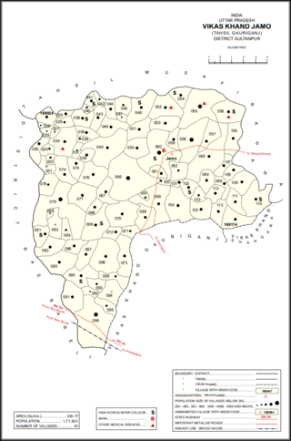
Jamo, also spelled Jamun or Jamon, is a village and community development block headquarters in Gauriganj tehsil of Amethi district, Uttar Pradesh, India. As of 2011, it had a population of 6,734 people, in 1,182 households. It was historically the capital of the pargana of Gaura Jamun. It is located at the intersection of four minor district roads, some of which are prone to flooding during the rainy season.

<span class="mw-page-title-main">Katari, Amethi</span> Village in Uttar Pradesh, India

Katari is a village in Jamo block of Amethi district, Uttar Pradesh, India. It is located by a stream called the Naiya or Kandu nala, which flows east toward the Gomti river. The main highway from Lucknow to Jaunpur passes further north. Katari was historically the seat of a taluqdari estate held by a leading branch of the Kanhpuria Rajputs.

References

  1. "GeoNames Search". geonames.nga.mil. Archived from the original on 12 April 2014. Retrieved 17 May 2023.
  2. 1 2 3 4 5 6 "Census of India 2011: Uttar Pradesh District Census Handbook – Rae Bareli, Part A (Village and Town Directory)" (PDF). Census 2011 India. pp. 142–58. Retrieved 30 July 2021.
  3. 1 2 3 4 5 6 7 8 9 10 11 12 13 14 15 16 17 18 19 20 21 22 23 24 25 26 27 28 29 30 31 32 33 Nevill, H.R. (1905). Rai Bareli: A Gazetteer, Being Volume XXXIX Of The District Gazetteers Of The United Provinces Of Agra And Oudh. Allahabad: Government Press. pp. 81–5, 197, 230. Retrieved 30 July 2021.
  4. 1 2 3 4 5 6 Census 1961: District Census Handbook, Uttar Pradesh (39 – Raebareli District) (PDF). Lucknow. 1965. pp. 144, 147, 166–7, 173, xxiv-xxv of section "Maharajganj Tahsil". Retrieved 30 July 2021.{{cite book}}: CS1 maint: location missing publisher (link)
  5. Census 1981 Uttar Pradesh: District Census Handbook Part XIII-A: Village & Town Directory, District Rae Bareli (PDF). 1982. pp. 58–9. Retrieved 30 July 2021.