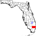
Carver Ranches, West Park, Florida

Last updated
Carver Ranches, Florida
Coordinates: 25°59′30″N80°11′30″W / 25.99167°N 80.19167°W / 25.99167; -80.19167 Coordinates: 25°59′30″N80°11′30″W / 25.99167°N 80.19167°W / 25.99167; -80.19167
Country Flag of the United States.svg  United States
State Flag of Florida.svg  Florida
County   Broward
Area
  Total0.7 sq mi (1.7 km2)
  Land0.7 sq mi (1.7 km2)
  Water0.0 sq mi (0.0 km2)
Elevation
10 ft (3 m)
Population
 (2000)
  Total4,299
  Density6,376.5/sq mi (2,462.0/km2)
Time zone UTC-5 (Eastern (EST))
  Summer (DST) UTC-4 (EDT)
FIPS code 12-10920 [1]
GNIS feature ID0280101 [2]

Carver Ranches was a census-designated place (CDP) in Broward County, Florida, United States. The population was 4,299 at the 2000 census.

Contents

In 2005 it became one of four neighborhoods to incorporate into the new city of West Park.

Geography

Carver Ranches is located at 25°59′30″N80°11′30″W / 25.99167°N 80.19167°W / 25.99167; -80.19167 (25.991718, -80.191716). [3]

According to the United States Census Bureau, the CDP has a total area of 1.7 km² (0.7 mi²), all land.

Demographics

Historical population
CensusPop.
1970 5,515
2000 4,299
source: [4] [5] [6]

As of the census [1] of 2000, there were 4,299 people, 1,340 households, and 1,027 families residing in the CDP. The population density was 2,477.4/km² (6,376.5/mi²). There were 1,428 housing units at an average density of 822.9/km² (2,118.1/mi²). The racial makeup of the CDP was 2.19% White (1.4% were Non-Hispanic White,) [7] 96.42% African American, 0.16% Native American, 0.02% Asian, 0.56% from other races, and 0.65% from two or more races. Hispanic or Latino of any race were 1.65% of the population.

There were 1,340 households out of which 33.8% had children under the age of 18 living with them, 36.0% were married couples living together, 33.7% had a female householder with no husband present, and 23.3% were non-families. 18.5% of all households were made up of individuals and 6.3% had someone living alone who was 65 years of age or older. The average household size was 3.20 and the average family size was 3.62.

In the CDP, the population was spread out with 32.3% under the age of 18, 8.7% from 18 to 24, 28.1% from 25 to 44, 19.4% from 45 to 64, and 11.5% who were 65 years of age or older. The median age was 32 years. For every 100 females, there were 85.5 males. For every 100 females age 18 and over, there were 82.2 males.

The median income for a household in the CDP was $26,613, and the median income for a family was $27,412. Males had a median income of $22,604 versus $21,213 for females. The per capita income for the CDP was $10,090. About 25.6% of families and 25.3% of the population were below the poverty line, including 31.5% of those under age 18 and 36.4% of those age 65 or over.

As of 2000, before being annexed to West Park, English as a first language accounted for 96.90% of all residents, while Spanish accounted for 2.19%, and French Creole as a mother tongue made up 0.90% of the population. [8]

Related Research Articles

Mojave Ranch Estates, Arizona CDP in Arizona, United States

Mojave Ranch Estates is a census-designated place (CDP) in Mohave County, Arizona, United States. The population was 28 at the 2000 census.

Valley Ranch, California census-designated place in California, United States

Valley Ranch is a census-designated place in Plumas County, California, United States. The population was 109 at the 2010 census, up from 92 at the 2000 census.

Green Meadow was a census-designated place (CDP) in Broward County, Florida, United States. The population was 1,875 at the 2000 census. It was incorporated into the town of Southwest Ranches, Florida in 2000.

Hillsboro Ranches was a census-designated place (CDP) in Broward County, Florida, United States in 2000. The population was 47 at the 2000 census. Hillsboro Ranches was not designated a CDP in the 2010 census. As of 2018, Hillsboro Ranches remains an unincorporated neighborhood, part of the Broward Municipal Services District, Northern County.

Rolling Oaks was a census-designated place (CDP) in Broward County, Florida, United States. The population was 1,291 at the 2000 census. It was incorporated into the town of Southwest Ranches, Florida in 2000, and is now a neighborhood.

Royal Palm Ranches is a former census-designated place (CDP) in Broward County, Florida, United States. The population was 294 at the 2000 census. It now serves as a community of Cooper City, Florida.

Sunshine Ranches is a former census-designated place (CDP) in Broward County, Florida, United States. The population was 1,704 at the 2000 census. It was incorporated into the town of Southwest Ranches, Florida in 2000, and now serves as a neighborhood.

Port Salerno, Florida CDP in Florida, United States

Port Salerno is a census-designated place (CDP) in Martin County, Florida, United States. The population was 10,091 at the 2010 census. It is part of the Port St. Lucie Metropolitan Statistical Area.

Homestead Base, Florida CDP in Florida, United States

Homestead Base is a census-designated place (CDP) in Miami-Dade County, Florida, United States. The population was 446 at the 2000 census.

Maunaloa, Hawaii Census-designated place in Hawaii, United States

Maunaloa or Mauna Loa is a census-designated place (CDP) in Maui County, Hawaiʻi, United States, in the western part of the island of Molokai. The population was 376 at the 2010 census.

Claiborne, Louisiana Census-designated place in Louisiana, United States

Claiborne is a census-designated place (CDP) in Ouachita Parish, Louisiana, United States. The population was 9,830 at the 2000 census. It is part of the Monroe Metropolitan Statistical Area.

Swartz, Louisiana Census-designated place in Louisiana, United States

Swartz is a census-designated place (CDP) in Ouachita Parish in northeastern Louisiana, United States. The population was 4,536 in the 2010 census, an increase of 289 or 6.8 percent over the 2000 population. It is part of the Monroe Metropolitan Statistical Area.

Canada Creek Ranch, Michigan Census-designated place & Unincorporated community in Michigan, United States

Canada Creek Ranch is an unincorporated community in Montmorency Township, Montmorency County in the U.S. state of Michigan. It is a census-designated place (CDP) used for statistical purposes. The population was 405 at the 2000 census.

Rio Lucio, New Mexico CDP in New Mexico, United States

Rio Lucio is a census-designated place (CDP) in Taos County, New Mexico, United States. The population was 379 at the 2000 census.

White Plains, North Carolina CDP in North Carolina, United States

White Plains is a census-designated place (CDP) in Surry County, North Carolina, United States. The population was 1,049 at the 2000 census.

McGovern, Pennsylvania Census-designated place in Pennsylvania, United States

McGovern is a census-designated place (CDP) in Washington County, Pennsylvania, United States. The population was 2,742 at the 2010 census.

K-Bar Ranch, Texas Census-designated place in Texas, United States

K-Bar Ranch is a census-designated place (CDP) in Jim Wells County, Texas, United States. The population was 358 at the 2010 census.

Zapata Ranch, Texas CDP in Texas, United States

Zapata Ranch is a census-designated place (CDP) in Willacy County, Texas, United States. The population was 108 at the 2010 census.

Windsor Heights, West Virginia Village in West Virginia, United States

Windsor Heights is a village in Brooke County, West Virginia, United States. It is part of the Wheeling, West Virginia Metropolitan Statistical Area. The population was 423 at the 2010 census. Grace Davis was the mayor as of June, 2017.

Rafter J Ranch, Wyoming CDP in Wyoming, United States

Rafter J Ranch is a census-designated place (CDP) in Teton County, Wyoming, United States. The population was 1,075 at the 2010 census. It is part of the Jackson, WY–ID Micropolitan Statistical Area.

References

  1. 1 2 "American FactFinder". United States Census Bureau. Archived from the original on 2020-02-12. Retrieved 2008-01-31.
  2. "US Board on Geographic Names". United States Geological Survey. 2007-10-25. Retrieved 2008-01-31.
  3. "US Gazetteer files: 2010, 2000, and 1990". United States Census Bureau. 2011-02-12. Retrieved 2011-04-23.
  4. "CENSUS OF POPULATION AND HOUSING (1790-2000)". U.S. Census Bureau. Archived from the original on 2010-07-08. Retrieved 2010-07-17.
  5. Returned as Carver Ranch Estates during the 1970 census
  6. Community was part of Miami Gardens-Utopia-Carver census area in 1980 & 1990
  7. "Demographics of Carver Ranches, FL". MuniNetGuide.com. Archived from the original on 2008-04-28. Retrieved 2007-11-16.
  8. "MLA Data Center Results of Carver Ranches, FL". Modern Language Association . Retrieved 2007-11-16.