The Territory of Louisiana or Louisiana Territory was an organized incorporated territory of the United States that existed from July 4, 1805, until June 4, 1812, when it was renamed the Missouri Territory. The territory was formed out of the District of Louisiana, which consisted of the portion of the Louisiana Purchase north of the 33rd parallel.
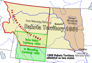
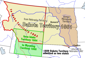
The Territory of Dakota was an organized incorporated territory of the United States that existed from March 2, 1861, until November 2, 1889, when the final extent of the reduced territory was split and admitted to the Union as the states of North and South Dakota.
The Territory of Washington was an organized incorporated territory of the United States that existed from March 2, 1853, until November 11, 1889, when the territory was admitted to the Union as the State of Washington. It was created from the portion of the Oregon Territory north of the lower Columbia River and north of the 46th parallel east of the Columbia. At its largest extent, it also included the entirety of modern Idaho and parts of Montana and Wyoming, before attaining its final boundaries in 1863.

The Territory of Wyoming was an organized incorporated territory of the United States that existed from July 25, 1868, until July 10, 1890, when it was admitted to the Union as the State of Wyoming. Cheyenne was the territorial capital. The boundaries of the Wyoming Territory were identical to those of the modern State of Wyoming.

The Territory of Idaho was an organized incorporated territory of the United States that existed from March 3, 1863, until July 3, 1890, when the final extent of the territory was admitted to the Union as Idaho.

The Territory of Montana was an organized incorporated territory of the United States that existed from May 26, 1864, until November 8, 1889, when it was admitted as the 41st state in the Union as the state of Montana.

The Territory of Nebraska was an organized incorporated territory of the United States that existed from May 30, 1854, until March 1, 1867, when the final extent of the territory was admitted to the Union as the state of Nebraska. The Nebraska Territory was created by the Kansas–Nebraska Act of 1854. The territorial capital was Omaha. The territory encompassed areas of what is today Nebraska, Wyoming, South Dakota, North Dakota, Colorado, and Montana.

The Dakotas, also known as simply Dakota, is a collective term for the U.S. states of North Dakota and South Dakota. It has been used historically to describe the Dakota Territory, and is still used for the collective heritage, culture, geography, fauna, sociology, economy, and cuisine of the two states.

The District of Louisiana, or Louisiana District, was an official and temporary United States government designation for the portion of the Louisiana Purchase that had not been organized into the Territory of Orleans or "Orleans Territory". The district officially existed from March 10, 1804, until July 4, 1805, when it was organized as the Louisiana Territory.

The Territory of Missouri was an organized incorporated territory of the United States that existed from June 4, 1812, until August 10, 1821. In 1819, the Territory of Arkansas was created from a portion of its southern area. In 1821, a southeastern portion of the territory was admitted to the Union as the State of Missouri, and the rest became unorganized territory for several years.

The territory of the United States and its overseas possessions has evolved over time, from the colonial era to the present day. It includes formally organized territories, proposed and failed states, unrecognized breakaway states, international and interstate purchases, cessions, and land grants, and historical military departments and administrative districts. The last section lists informal regions from American vernacular geography known by popular nicknames and linked by geographical, cultural, or economic similarities, some of which are still in use today.

The Great Sioux Reservation is an Indian reservation created by the United States through treaty with the Sioux, principally the Lakota, who dominated the territory before its establishment. In the Fort Laramie Treaty of 1868, the reservation included lands west of the Missouri River in South Dakota and Nebraska, including all of present-day western South Dakota. The treaty also provided rights to roam and hunt in contiguous areas of North Dakota, Montana Wyoming, and northwest Colorado.
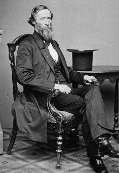
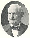
John Blair Smith Todd was a Delegate from Dakota Territory to the United States House of Representatives and a general in the Union Army during the American Civil War.
At large is a description for members of a governing body who are elected or appointed to represent a whole membership or population, rather than a subset. In multi-hierarchical bodies, the term rarely extends to a tier beneath the highest division. A contrast is implied, with certain electoral districts or narrower divisions. It can be given to the associated territory, if any, to denote its undivided nature, in a specific context. Unambiguous synonyms are the prefixes of cross-, all- or whole-, such as cross-membership, or all-state.

Idaho Territory's at-large congressional district is an obsolete congressional district that encompassed the area of the Idaho Territory, which was originally created from parts of the Washington Territory and Dakota Territory in 1863. In 1864, parts of the territory were ceded back to the Dakota Territory and another part was reorganized into the Montana Territory. The boundaries of the territory were changed again in 1868 when the Wyoming Territory was created.
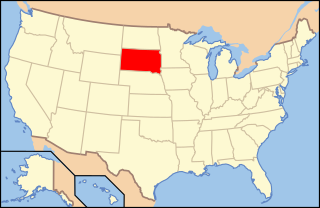
The following is an alphabetical list of articles related to the U.S. state of South Dakota.

The following outline is provided as an overview of and topical guide to the U.S. state of Wyoming:

The following outline traces the territorial evolution of the U.S. State of Wyoming.
The following outline traces the territorial evolution of the U.S. State of South Dakota.
The 27th meridian west from Washington is an archaic meridian based on the Washington Meridian. The meridian is approximately 104 degrees west of the Prime Meridian. It is used as the boundary of five states of the United States.