
Stutfield Peak is a mountain in Jasper National Park, Alberta, Canada. It is located at the northern end of the Columbia Icefield, 6 kilometres (3.7 mi) north-west from Mount Kitchener, in the Winston Churchill Range of the Canadian Rockies. The peak has two summits - Stutfield East and Stutfield West - and is therefore sometimes referred to as The Stutfields. The West peak is higher than the East peak by 50 m (164 ft).

Mount GEC is a mountain located in the Sunwapta River Valley of Jasper National Park. Gec lies 4 km (2 mi) northwest of Diadem Peak. The mountain was named in 1961 after the first names of the three climbers who made the first ascent — George, Ellen, and Chuck.
Mount Nelson is a mountain located near the west branch of Lynx Creek in Jasper National Park, Alberta, Canada.

The Fairholme Range is a mountain range east of the Bow River valley in the Canadian Rockies. The range is bounded on the west side by the Trans-Canada Highway as it passes through the towns of Exshaw and Canmore, while the northern section of the range extends into Banff National Park to the southern shores of Lake Minnewanka. John Palliser named the range in 1859 after his sister Grace Fairholme, who had married William Fairholme.

Mount Brazeau is a mountain in Alberta, Canada.

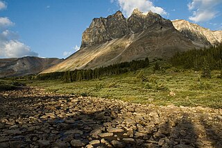
Pyramid Mountain is a mountain in Jasper National Park, Alberta, Canada, named for its pyramid-like shape. James Hector named the mountain in 1859 due to its appearance from the Athabasca River valley on the eastern side of the peak.

The Beaverfoot Range is a mountain range in the Kootenay Ranges of the Canadian Rockies, located in southeastern British Columbia. The range extends from Cedared Creek near Spillimacheen north to the Kicking Horse River.

The Jacques Range is a mountain range in the Front Ranges of the Canadian Rockies, located south of Highway 16 and Jasper Lake in Jasper National Park, Alberta, Canada.
Mount Rutherford is a mountain in Jasper National Park in Alberta, Canada. It is part of the Northern Front Ranges of the Canadian Rockies. Its peak stands 3 km (2 mi) east of Harvey Lake and north of the Snaring River, a tributary of the Athabasca River.

Mount Bridgland is a 2,930-metre (9,610 ft) mountain located in the Victoria Cross Ranges of Jasper National Park in Alberta, Canada. It was named by Frank Sissons in 1923 after Morrison P. Bridgland (1878-1948), a Dominion Land Surveyor who named many peaks in Jasper Park and the Canadian Rockies.

Utopia Mountain is a 2,602-metre (8,537-foot) mountain in the Miette Range of Jasper National Park, in the Canadian Rockies of Alberta, Canada. It was named by Morrison P. Bridgland in 1916. Bridgland (1878-1948) was a Dominion Land Surveyor who named many peaks in Jasper Park and the Canadian Rockies.

Roche de Smet is a 2,539 m (8,330 ft) mountain summit located in the Athabasca River valley of Jasper National Park in Alberta, Canada. It is situated in the De Smet Range of the Canadian Rockies. It was named in 1896 after Pierre-Jean De Smet.

Mount Kerkeslin is a 2,984 m (9,790 ft) mountain summit located in the Athabasca River valley of Jasper National Park, in the Canadian Rockies of Alberta, Canada. It is the highest peak of the Maligne Range. It is located in the south part of the Maligne Range, east of the Icefields Parkway and is visible from the Athabasca Falls lookout. Mount Kerkeslin is composed of sedimentary rock laid down during the Cambrian period and pushed east and over the top of younger rock during the Laramide orogeny.

Lynx Mountain is a mountain peak in the Canadian Rockies. It is located on the Continental Divide between the provinces of Alberta and British Columbia, in the Cushina Ridge of the Continental Ranges. It was named by Lucius Quincy Coleman for the remains of a lynx they found on the ice of the nearby Coleman Glacier in 1908.
Dungeon Peak is a 3,129-metre (10,266 ft) mountain summit located on the shared border of Jasper National Park in Alberta, and Mount Robson Provincial Park in British Columbia, Canada. Dungeon Peak is part of The Ramparts in the Tonquin Valley. The descriptive name was applied in 1916 by Morrison P. Bridgland (1878-1948), a Dominion Land Surveyor who named many peaks in Jasper Park and the Canadian Rockies. The mountain's name was made official in 1935 by the Geographical Names Board of Canada.

Roche Bonhomme is a 2,495-metre (8,186-foot) mountain summit located in Jasper National Park in Alberta, Canada. It is located in the Colin Range, which is a sub-range of the Canadian Rockies. The peak is situated 13 km (8.1 mi) northeast of the municipality of Jasper, and is a prominent landmark in the Athabasca Valley visible from Highway 16 and the Canadian. Its nearest higher peak is Grisette Mountain, 2.2 km (1.4 mi) to the east.

Chetamon Mountain is a 2,606-metre (8,550-foot) mountain summit located in Jasper National Park, in the De Smet Range of the Canadian Rockies in Alberta, Canada. The peak is situated 18 kilometres (11 mi) north of the municipality of Jasper, in the Athabasca Valley and is visible from Highway 16 and the Canadian. Its nearest higher peak is Cliff Mountain, 3.5 km (2.2 mi) to the northwest.

Roche Miette is a 2,316-metre (7,598-foot) mountain at the northwestern tip of the Miette Range in Jasper National Park, in the Canadian Rockies of Alberta, Canada. The peak is a prominent landmark in the Athabasca Valley that is situated approximately thirty kilometres north-northeast of the municipality of Jasper, and four kilometres northeast of the Jasper House National Historic Site. It is visible from Highway 16 and the Canadian. Its nearest higher peak is Capitol Mountain, 5.0 km (3.1 mi) to the southeast. Roche Miette translates from French as Crumb Rock.
Mount Tekarra is a 2,694-metre (8,839-foot) mountain summit located in the Athabasca River valley of Jasper National Park, in the Canadian Rockies of Alberta, Canada. It is situated at the northwest end of the Maligne Range and is visible from Jasper and the Icefields Parkway. The nearest higher neighbor is The Watchtower, 7.0 km (4.3 mi) to the east.
Roche Noire is a 2,920-metre (9,580 ft) mountain located in Alberta, Canada.

