The forest cover in Russia by federal subject as published by the Unified Interdepartmental Statistical Information System. As of 2021 49.4% of Russia is covered in trees.[2]
Contents
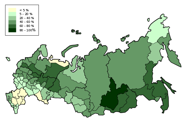


The forest cover in Russia by federal subject as published by the Unified Interdepartmental Statistical Information System. As of 2021 49.4% of Russia is covered in trees.[2]

Russia is the largest country in the world, covering over 17,125,191 km2 (6,612,073 sq mi), and encompassing more than one-eighth of Earth's inhabited land area. Russia extends across eleven time zones, and has the most borders of any country in the world, with sixteen sovereign nations.

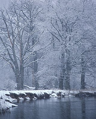
Taiga or tayga, also known as boreal forest or snow forest, is a biome characterized by coniferous forests consisting mostly of pines, spruces, and larches. The taiga or boreal forest is the world's largest land biome. In North America, it covers most of inland Canada, Alaska, and parts of the northern contiguous United States. In Eurasia, it covers most of Sweden, Finland, much of Russia from Karelia in the west to the Pacific Ocean, much of Norway and Estonia, some of the Scottish Highlands, some lowland/coastal areas of Iceland, and areas of northern Kazakhstan, northern Mongolia, and northern Japan.

The Caucasus Mountains is a mountain range at the intersection of Asia and Europe. Stretching between the Black Sea and the Caspian Sea, they are surrounded by the Caucasus region and are home to Mount Elbrus, the highest peak in Europe at 5,642 metres (18,510 ft) above sea level.

Bryansk Oblast, also known as Bryanshchina, is a federal subject of Russia. Its administrative center is the city of Bryansk. As of the 2021 Census, its population was 1,169,161.
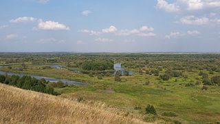
The West Siberian Plain is a large plain that occupies the western portion of Siberia, between the Ural Mountains in the west and the Yenisei River in the east, and the Altai Mountains on the southeast. Much of the plain is poorly drained and consists of some of the world's largest swamps and floodplains. Important cities include Chelyabinsk, Novosibirsk, Omsk, and Tomsk, as well as Surgut and Nizhnevartovsk.
The Chugach National Forest is a 6,908,540-acre (27,958 km2) United States National Forest in south central Alaska. Covering portions of Prince William Sound, the Kenai Peninsula and the Copper River Delta, it was formed in 1907 from part of a larger forest reserve. The Chugach includes extensive shorelines, glaciers, forests and rivers, much of which is untouched by roads or trails. It hosts numerous bird, mammal and marine species, including extensive shorebird habitat and a bald eagle population larger than the contiguous 48 states combined. Human industry in the forest includes extensive tourism and some mining and oil and gas operations.
Ural is a geographical region located around the Ural Mountains, between the East European and West Siberian plains. It is considered a part of the Eurasian Steppe, extending approximately from the North to the South; from the Arctic Ocean to the end of the Ural River near Orsk city. The border between Europe and Asia runs along the Eastern side of the Ural Mountains. Ural mostly lies within Russia but also includes a small part of Northwestern Kazakhstan. This is historical, not an official entity, with borders overlapping its Western Volga and Eastern Siberia neighboring regions. At some point in the past, parts of the currently existing Ural region were considered a gateway to Siberia, or even Siberia itself, and were combined with the Volga administrative the divisions. Today, there are two official namesake entities: the Ural Federal District and the Ural economic region. While the latter follows the historical borders, the former is a political product; the District omits Western Ural and includes Western Siberia instead.
Akkol, formerly known as Alexeyevka, is a town in northern Kazakhstan. It is located 100 kilometres (62 mi) north of the national capital Nur-Sultan along the highway between Nur-Sultan and the Burabay National Nature Park. The town is the administrative centre of Aqköl District of Aqmola Region. Most of the people are Kazakhs and Russians. There are smaller minorities of Ukrainians and Germans. The population is 14,217 ;15,682.

Climate change has serious effects on Russia's climate, including average temperatures and precipitation, as well as permafrost melting, more frequent wildfires, flooding and heatwaves. Changes may affect inland flash floods, more frequent coastal flooding and increased erosion reduced snow cover and glacier melting, and may ultimately lead to species losses and changes in ecosystem functioning.

Belarus is a landlocked, generally flat country without natural borders, that occupies an area of 207,600 square kilometers (80,200 sq mi). Its neighbors are Russia to the east and northeast, Latvia to the north, Lithuania to the northwest, Poland to the west, and Ukraine to the south. Its extension from north to south is 560 km (350 mi), from west to east is 650 km (400 mi).
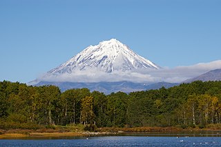
The wildlife of Russia inhabits terrain that extends across 12 time zones and from the tundra region in the far north to the Caucasus Mountains and prairies in the south, including temperate forests which cover 70% of the country. Russia's forests comprise 22% of the forest in the world as well as 33% of all temperate forest.

Dobryansky district was an administrative district of Perm Krai, Russia. Its centre is the town of Dobryanka. Its area is 5,192 km2, 70% of which covered by forest. Main minerals are oil, gypsum and gravel.

Nechkinsky National Park is an important biological and cultural reserve of Udmurtia, situated in the middle valley of the Kama River, its tributary the Siva River, and the coastal part of the Votkinsk reservoir. This places Nechkinsky on the western side of the central Ural Mountains. The territory is mostly forest and river floodplains, with a number of ancient archaeological sites on the grounds. It is near the city of Izhevsk.
The Bryansk Forest Nature Reserve, also known as Bryansky Les, is a nature reserve in Bryansk Oblast, Russia, along the Nerussa River near the Russian border with Ukraine.
Voronina (Voroninsky) Nature Reserve is a strict ecological reserve located in the valley of the Vorona River, in the forest-steppe zone of southwest Russia. The Voroninsky Reserve protects riverine wetlands in the southeast of the Oka–Don Plain. The reserve is situated in Kirsanovsky and Inzhavinsky districts of Tambov Oblast, about 100 km southeast of the city of Tambov. It was created in 1994, and covers an area of 10,819 ha (41.77 sq mi).

Privolzhskaya Lesostep Nature Reserve is a Russian zapovednik situated in the watershed midway between the Volga River and the Don River. The reserve is divided into 5 sectors, all in the western part of the Volga Uplands. Three of the sectors are steppe terrain, and two are forests. Rivers with upper reaches in the reserve flow into both the Don and the Volga. Administratively, the reserve is situated in the Kuznetsky District of Penza Oblast. The reserve was formally established in 1989 with the stated purpose of protecting representative habitat of the northern steppes, and the transition zone from steppe to forest. Some sections of the reserve, however, have been protected since 1919. In all, the reserve sectors cover an area of 8,373 ha (32.33 sq mi), and has additional buffer zones out to 1 km from the reserve borders.

Kologrivski Forest Nature Reserve is a Russian 'zapovednik' created to protect and study southern taiga nature complexes of the Russian Plain. The reserve includes the only two surviving old-growth southern European taiga arrays not exposed landscape changes. Some trees are 350–400 years old. The reserve hosts 38 out of 72 species of rare and endangered species in the Kostroma region. The reserve is situated in the Kologrivsky District of Kostroma Oblast. It was formally established in 2006, and is officially named State Nature Reserve "MG Sinitsyn", after its first administrator. The site covers 58,940 ha (227.6 sq mi).
Forest cover is the amount of trees that covers a particular area of land. It may be measured as relative or absolute. Nearly a third of the world's land surface is covered with forest, with closed-canopy forest accounting for 4 - 5 billion hectares of land. Forests provide many ecosystem services that humans and animals cannot survive without, but anthropogenic actions and climate change are threatening global forest cover in potentially irreversible ways.

Ladoga Skerries National Park is located on the north and northwestern shores of Lake Ladoga in the Republic of Karelia, Russia. The park features numerous small rocky islands (skerries) on narrow bays and channels. The park was officially created in 2017.
a. ^ Not recognized internationally as a part of Russia.