Glasgow East End Regeneration Route

Last updated

UK road A728.svg
A728
Route information
Length4.0 mi [1] [2] [3] [4]  (6.4 km)
Major junctions
South end Oatlands / King's Park
North end Parkhead / Gorbals
Location
Country United Kingdom
Constituent country Scotland
Road network
UK road A727.svg A727 UK road A730.svg A730

The Glasgow East End Regeneration Route (GEERR) is a new road in the East End of Glasgow, Scotland. The first phase was opened in 2011 with the second phase opened in mid-2012; these two phases are officially known as the A728 Clyde Gateway. A third phase from the Parkhead Bypass to Provan (M8/M80) was scheduled for construction in 2018, but may not now be built. Another nearby road in the city also has the A728 designation.

Contents

History

2012 view of the newly-opened Glasgow East End Regeneration Route from its junction with the A74 (London Road) looking northwards towards Gallowgate (with the Provan Gas Works beyond) East End Regeneration Route (geograph 3062624).jpg
2012 view of the newly-opened Glasgow East End Regeneration Route from its junction with the A74 (London Road) looking northwards towards Gallowgate (with the Provan Gas Works beyond)

The history of the route goes back to the Glasgow Inner Ring Road (IRR) project of the 1960s. Owing largely to public opposition, only the northern and western flanks of this were ever built (this is now the central section of the M8). With the resultant chronic traffic congestion on the M8, only in 2011 was the southern flank, the M74 Completion, finally opened after much local opposition. [5] The construction of the EERR link is intended to provide an 'inner circle' connecting the new section of M74 at Polmadie Road with the M8 at Provan.

Route

2012 aerial view of the road's route from the east, from the point of it crossing the River Clyde at Rutherglen Bridge (top left), running through Dalmarnock, passing Celtic Park and terminating north of Parkhead at Duke Street (bottom right) Parkhead from the air (geograph 2987425).jpg
2012 aerial view of the road's route from the east, from the point of it crossing the River Clyde at Rutherglen Bridge (top left), running through Dalmarnock, passing Celtic Park and terminating north of Parkhead at Duke Street (bottom right)

The route of the EERR was planned as early as 1965 by the then Glasgow Corporation after the Glasgow Inner Ring Road proposals originating from the Bruce Report, and was originally a continuation of the Stirling Motorway (which would be realised as the M80) which would have run directly south beyond the interchange with the Monkland Motorway (the present-day M8) at Provan Gas Works. This road would have driven south towards the extended South Link Motorway (now the M74) and would have served as an "outer ring" for the city. As the appetite for further inner urban motorway developments waned in the 1970s following the backlash when the city centre section of the IRR was built in the late 1960s, the route evolved into an urban thoroughfare instead.

The M80, when eventually built in the early 1990s, now terminated at the Provan Gas Works interchange, whilst the Parkhead bypass, constructed in 1988 as part of the Parkhead Forge shopping development, was effectively the first section of the EERR. From Parkhead, the road would cut northward, through Hogarth Park, a former railway embankment now used as public open space. The new road would run between Haghill and Carntyne, under Edinburgh Road and Cumbernauld Road continuing along the old Caledonian Railway "Switchback" line to the M8/M80 junction at Provan.

A planning application was submitted for the southern section of the EERR, named the Clyde Gateway, in October 2005, but the winning of Host City for the 2014 Commonwealth Games provided the necessary impetus. Phase 1, from junction 1A of the now-completed M74 extension Polmadie Road to Shawfield opened in April 2007 as part of the Oatlands development. Phase 2 [6] was completed in April 2012 and designated as the A728. [7] It passes Shawfield Stadium, over the River Clyde at Rutherglen Bridge and past Dalmarnock railway station (where it meets the A749), before linking up with the Parkhead bypass (A74) and the new stadia district (Celtic Park and the Sir Chris Hoy Velodrome), joining the existing road network at the Forge Retail Park. [6]

Progress

Construction of phase 3, linking north from the A89 Parkhead Bypass to the M8 at Provan along a disused railway line, was planned to commence after the 2014 Commonwealth Games. [6] In January 2016, Glasgow City Council approved the construction of this 0.9 miles (1.4 km) phase with works then expected to start in 2018 [8] and to be complete in 2021, at an estimated cost of £60 million. [9] [10] As of 2020, the plan was reported to have been quietly forgotten in 2019 as funding was unlikely to be made available. [11] It was confirmed subsequently that the project was still under consideration, with a motion to cancel it officially on environmental grounds being rejected by the council in June 2021. [12] In October 2021, the route was formally cancelled. [13]

South Side A728

The creation of the Glasgow East End Regeneration Route led to it being designated as the A728; however there was already a major road in Glasgow, located nearby but entirely separate, with this designation. The 'old' A728 is a suburban route of 2.4 miles (3.9 km) length which runs southwards from the Gorbals district starting at a junction with the A74 road (Ballater Street) at the City of Glasgow College just south of the River Clyde – northwards from this junction (Albert Bridge leading to Saltmarket) is considered to be the A8. Known as Laurieston Road at this point, it briefly joins the A730 as they pass the ruined Caledonia Road Church  [ de ] on either side, [14] then continues south as Cathcart Road while the A730 turns eastwards.

It crosses over the M74 motorway without linking to it, as well as over the West Coast Main Line railway, then turns southeast as Aikenhead Road, passing the east side of the Govanhill district. After crossing the B763 (Calder Street, leading on to Junction 1A of the M74) at Polmadie, it passes close to Holyrood Secondary School, Cathkin Park, Toryglen Regional Football Centre and Hampden Park, terminating at the east/west-running King's Park Avenue (B766, changing to the B762 from this point eastwards). The north/south road continues under the Cathcart Circle Line railway bridge and onwards, mostly uphill, to Simshill, Castlemilk and Carmunnock as the B766.

After the completion of both the GEERR and the M74, the 0.6 miles (0.97 km) stretch of Polmadie Road – between the 'old' A728 and the M74 Junction 1A, for which it is the on/off slip feeder road – subsequently took the A728 designation as well (according to motorway gantry signage and Google Maps as of 2021, whereas local signs still indicate it as being the B763); [15] this had previously been blocked off from Aikenhead Road until construction on the motorway began and a junction was created as a new access route, particularly for Hampden Park traffic. Irrespective of whether Polmadie Road is officially the A728, technically the GEERR does not connect to the motorway under that name, instead this ends at Shawfield Stadium, with the section of new road between the stadium and Hutchesontown (skirting around the reconstructed Oatlands neighbourhood with the motorway junction halfway along) labelled as part of the A730, which in the other direction continues south-eastwards to Rutherglen.

Public transport

The '75' bus service, one of the primary routes by the major operator in the region, First Glasgow, runs along the entire length of the 'old' A728 in both directions from the point of passing Caledonia Road Church (coincidentally also the location of the company's headquarters and depot since 2014). [16]

Related Research Articles

M6 motorway Longest motorway in England

The M6 motorway is the longest motorway in the United Kingdom. It is located entirely within England, running for just over 230 miles (370 km) from the Midlands to the border with Scotland. It begins at Junction 19 of the M1 and the western end of the A14 at the Catthorpe Interchange, near Rugby before heading north-west. It passes Coventry, Birmingham, Wolverhampton, Stoke-on-Trent, Preston, Lancaster and Carlisle before terminating at Junction 45 near Gretna. Here, just short of the Scottish border it becomes the A74(M) which continues to Glasgow as the M74. Its busiest sections are between junctions 4 and 10a in the West Midlands, and junctions 16 to 19 in Cheshire; these sections have now been converted to smart motorways.

Rutherglen Human settlement in Scotland

Rutherglen is a town in South Lanarkshire, Scotland, immediately south-east of the city of Glasgow, 3 miles (5 km) from its centre and directly south of the River Clyde. Having existed as a Lanarkshire burgh in its own right for more than 800 years, in 1975 Rutherglen lost its own local council and administratively became a component of the City of Glasgow District within the Strathclyde region. In 1996 the towns were reallocated to the South Lanarkshire council area.

M8 motorway (Scotland) Busiest motorway in Scotland

The M8 is the busiest motorway in Scotland and one of the busiest in the United Kingdom. It connects the country's two largest cities, Glasgow and Edinburgh, and serves other large communities including Airdrie, Coatbridge, Greenock, Livingston and Paisley. The motorway is 60 miles (97 km) long. A major construction project to build the final section between Newhouse and Baillieston was completed on 30 April 2017. The motorway has one service station, Heart of Scotland Services, previously named Harthill due to its proximity to the village.

A74(M) and M74 motorways Major motorway in Scotland

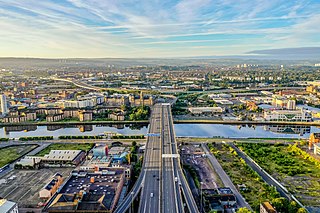
The A74(M) and M74 form a major motorway in Scotland, connecting it to England. The routes connect the M8 motorway in central Glasgow to the Scottish-English border at Gretna. In conjunction with the M6 motorway, they form one of the three major cross-border routes between Scotland and England. They are part of the unsigned international E-road network E05. Although the entire route is colloquially referred to as the M74, for more than half its length, south of Abington, the road is officially the A74(M); see naming confusion below.

M80 motorway Motorway in Scotland

The M80 is a motorway in Scotland's central belt, running between Glasgow and Stirling via Cumbernauld and Denny and linking the M8, M73 and M9 motorways. Following completion in 2011, the motorway is 25 miles (40 km) long. Despite being only a two lane motorway, parts of the M80 Stepps Bypass are used by around 60,000 vehicles per day.

A74 road

The A74 also known historically as the Glasgow to Carlisle Road, was a major road in the United Kingdom, linking Glasgow in Scotland to Carlisle in the North West of England, passing through Clydesdale, Annandale and the Southern Uplands. A road in this area has existed since Roman Britain, and it was considered one of the most important roads in Scotland, being used as a regular mail service route.

Transport in Glasgow Overview of transport in Glasgow

The city of Glasgow, Scotland has a transport system encompassing air, rail, road, and an underground rail line. Prior to 1962, the city was also served by trams. Commuters travelling into Glasgow from the neighbouring local authorities of North and South Lanarkshire, Renfrewshire, East Renfrewshire, and East and West Dunbartonshire have a major influence on travel patterns, with tens of thousands of residents commuting into the city each day. The most popular mode of transport in the city is the car, used by two thirds of people for journeys around the city.

Dalmarnock is a district in the Scottish city of Glasgow. It is situated east of the city centre, directly north of the River Clyde opposite the town of Rutherglen. It is also bounded by the Glasgow neighbourhoods of Parkhead to the north-east and Bridgeton to the north-west.

Oatlands, Glasgow Human settlement in Scotland

Oatlands is an area in the city of Glasgow, Scotland. It is situated south of the River Clyde, falls within the Southside Central ward under Glasgow City Council, and is part of the Gorbals historic area. Its boundaries are Hutchesontown and the Southern Necropolis cemetery to the west, Polmadie to the south, Shawfield to the east, and Glasgow Green public park to the north.

Polmadie Human settlement in Scotland

Polmadie is a primarily industrial area of Glasgow in Scotland. Situated south of the River Clyde, Polmadie is close to residential neighbourhoods including Govanhill and Toryglen (south-east), with Oatlands and another large industrial zone at Shawfield to the north on the opposite side of major railway lines and the M74 motorway, Junction 1A of which serves the area.

Glasgow Inner Ring Road

The Glasgow Inner Ring Road was a proposed ring road encircling the city centre of Glasgow, Scotland. Construction of the roads began in 1965, and half of its circumference was completed by 1972, but no subsequent construction was made and the remaining plans were formally abandoned in 1980. After 30 years, a route following roughly the southern section of the proposals have also been created as the new M74.

A725 road

The A725 road in Scotland is a major route which is a trunk road dual carriageway for almost its whole length, connecting several of the large towns of North Lanarkshire and South Lanarkshire, linking the M8 and M74 motorways; it has been upgraded frequently since its construction, with the most recent major work completed in 2017. In combination with the A726 road which meets the M77 motorway, it forms a southern and eastern bypass for the city of Glasgow.

A726 road

The A726 road in Scotland is a major route with several distinct sections with different characteristics and names; owing to its stages of construction, since 2005 it has two separate parts, the first running between Strathaven in South Lanarkshire and Junction 5 of the M77 motorway south of Newton Mearns in East Renfrewshire via East Kilbride, and the other running between Junction 3 of the M77 and the M898 motorway near the Erskine Bridge, via Paisley and Junction 29 of the M8 motorway near Glasgow International Airport.

A730 road

The A730 road in Scotland runs between the centre of Glasgow and the south-eastern edge of the city's urban area at Cathkin.

A749 road

The A749 road in Scotland connects East Kilbride with Glasgow city centre via Rutherglen and Bridgeton.

Rosebery Park was a football ground in the Oatlands area of Glasgow, Scotland. It was the home of Shawfield F.C. from 1918 to 1960, before being acquired by Glasgow Corporation as a venue for schools' football matches. The discovery that the site was contaminated led to the ground becoming derelict in the 1990s, and it was subsequently demolished.

The Switchback was a railway line in the East End of Glasgow, Scotland, constructed by the Caledonian Railway (CR). Connecting the lines at Rutherglen on the south side of the city with Robroyston on the north side, this route also served a number of industrial sidings and rail yards.

Shawfield Human settlement in Scotland

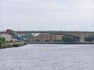
Shawfield is an industrial/commercial area of the Royal Burgh of Rutherglen in South Lanarkshire, Scotland, located to the north of the town centre. It is bordered to the east by the River Clyde, to the north by the Glasgow neighbourhood of Oatlands and the adjacent Richmond Park, to the south-west by Glasgow's Polmadie and Toryglen districts, and to the south-east by Rutherglen's historic Main Street and its Burnhill neighbourhood, although it is separated from these southerly areas by the West Coast Main Line railway tracks and the M74 motorway. A road bridge connects Shawfield to the Dalmarnock, Bridgeton and Glasgow Green areas.

Rutherglen Bridge

The Rutherglen Bridge or the Shawfield Bridge is a bridge which was built 1893–96, which crosses the River Clyde, in Scotland.

A724 road

The A724 road in Scotland runs within South Lanarkshire between Rutherglen and Hamilton. It follows an ancient route which is marked on William Roy's Lowland Map of Scotland (1755) with only minor deviations from its modern course.

References

  1. Glasgow East End Regeneration Route section = 1.6 miles
  2. "Directions from Glasgow, Scotland, UK G5 0AW to Clyde Gateway, Glasgow, Scotland, UK G31 4BH". Google Maps. Retrieved 4 September 2021.
  3. South Side section (not including Polmadie Road) = 2.4 miles
  4. "Directions from Glasgow, Scotland, UK G5 0RJ to Glasgow, Scotland, UK G44 4QT". Google Maps. Retrieved 3 September 2021.
  5. "M74 extension: Will the gap ever be filled?". The Herald. 10 December 2007. Retrieved 6 September 2021.
  6. 1 2 3 "New £25m Clyde Gateway road opens in Glasgow". BBC News. BBC. 26 April 2012. Retrieved 24 June 2012.
  7. "Directions to Clyde Gateway". Google . Retrieved 15 February 2017.
  8. Brown, Richard (21 January 2016). "East End Regeneration Route : Phase 3" (PDF). Glasgow City Council. Retrieved 15 February 2017.
  9. Braiden, Gerry (18 January 2016). "£60m completion of motorway link road in Glasgow's east end given green light". Herald Scotland. Retrieved 15 February 2017.
  10. Final phase of £60m Glasgow carriageway set for approval, Scottish Construction Now, 18 January 2016
  11. A728 East End Regeneration Route Phase 3, roads.org.uk. Accessed 26 October 2020
  12. Bid to drop East End road project due to climate emergency concerns fails, Glasgow Times, 18 June 2021. Retrieved 6 September 2021
  13. Sandelands, Drew (29 October 2021). "Glasgow four lane road through East End ditched amid climate concerns". GlasgowLive. Retrieved 30 October 2021.
  14. Caledonia Road Church, Discover Glasgow
  15. Roadworks in the rain,Glasgow, Scotland, Alamy, 26 September 2016
  16. 75 | Milton – Castlemilk, First Glasgow, 9 April 2018. Retrieved 3 September 2021

Coordinates: 55°51′19″N4°12′13″W / 55.8553°N 4.2037°W / 55.8553; -4.2037