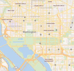
Rock Creek Park is a large urban park that bisects the Northwest quadrant of Washington, D.C. Created by Act of Congress in 1890, the park comprises 1,754 acres, generally along Rock Creek, a tributary of the Potomac River.

Georgetown is a historic neighborhood and commercial district in Northwest Washington, D.C., situated along the Potomac River. Founded in 1751 as part of the colonial-era Province of Maryland, Georgetown predated the establishment of Washington, D.C. by 40 years. Georgetown was an independent municipality until 1871 when the United States Congress created a new consolidated government for the entire District of Columbia. A separate act, passed in 1895, repealed Georgetown's remaining local ordinances and renamed Georgetown's streets to conform with those in Washington, D.C.

The Baltimore–Washington Parkway is a controlled-access parkway in the U.S. state of Maryland, running southwest from Baltimore to Washington, D.C. The road begins at an interchange with U.S. Route 50 (US 50) near Cheverly in Prince George's County at the Washington, D.C., border, and continues northeast as a parkway maintained by the National Park Service (NPS) to MD 175 near Fort Meade, serving many federal institutions. This portion of the parkway is dedicated to Gladys Noon Spellman, a representative of Maryland's 5th congressional district, and has the unsigned Maryland Route 295 (MD 295) designation. Commercial vehicles, including trucks, are prohibited within this stretch. This section is administered by the NPS's Greenbelt Park unit. After leaving park service boundaries the highway is maintained by the state and signed with the MD 295 designation. This section of the parkway passes near Baltimore–Washington International Thurgood Marshall Airport.
The Rock Creek and Potomac Parkway, informally called the Rock Creek Parkway, is a parkway maintained by the National Park Service as part of Rock Creek Park in Washington, D.C. It runs next to the Potomac River and Rock Creek in a generally north–south direction, carrying four lanes of traffic from the Lincoln Memorial and Arlington Memorial Bridge north to a junction with Beach Drive near Connecticut Avenue at Calvert Street, N.W., just south of the National Zoological Park. During rush hours, the parkway is converted to one-way traffic corresponding to the peak direction of travel: southbound in the morning and northbound in the afternoon.
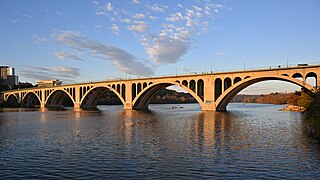
The Francis Scott Key Bridge, more commonly known as the Key Bridge, is a six-lane reinforced concrete arch bridge carrying U.S. Route 29 (US 29) across the Potomac River between the Rosslyn neighborhood of Arlington County, Virginia, and the Georgetown neighborhood of Washington, D.C. Completed in 1923, it is Washington's oldest surviving road bridge across the Potomac River.
The Clara Barton Parkway is a parkway in the U.S. state of Maryland and the District of Columbia. The highway runs 6.8 miles (10.9 km) from MacArthur Boulevard in Carderock, Maryland, east to Canal Road at the Chain Bridge in Washington. The Clara Barton Parkway is a two- to four-lane parkway that parallels the Potomac River and the Chesapeake and Ohio Canal (C&O) in southwestern Montgomery County, Maryland, and the far western corner of Washington. The parkway provides access to the communities of Cabin John and Glen Echo and several units of the Chesapeake and Ohio Canal National Historical Park. The Maryland portion of the George Washington Memorial Parkway was constructed from Carderock past Interstate 495 (I-495) to Glen Echo in the early to mid-1960s. The parkway was proposed to continue west to Great Falls and east to Georgetown. However, these proposals never came to fruition and the parkway was extended only to the Chain Bridge in the early 1970s. The Maryland portion of the George Washington Memorial Parkway was renamed in 1989 for Clara Barton, the founder of the American Red Cross, and whose original headquarters is located in Glen Echo.

The Taft Bridge is a historic bridge located in the Northwest quadrant of Washington, D.C. It carries Connecticut Avenue over the Rock Creek gorge, including Rock Creek and the Rock Creek and Potomac Parkway, connecting the neighborhoods of Woodley Park and Kalorama. It is named after former United States president and Supreme Court Chief Justice William Howard Taft, and sits to the southwest of the Duke Ellington Bridge.

The Dumbarton Bridge, also known as the Q Street Bridge and the Buffalo Bridge, is a historic masonry arch bridge in Washington, D.C.
This is a list of properties and districts in Washington, D.C., on the National Register of Historic Places. There are more than 600 listings, including 74 National Historic Landmarks of the United States and another 13 places otherwise designated as historic sites of national importance by Congress or the President.

Lyndon Baines Johnson Memorial Grove on the Potomac is located on Lady Bird Johnson Park, in Washington, D.C. The presidential memorial honors the 36th President of the United States, Lyndon B. Johnson.

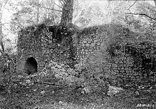
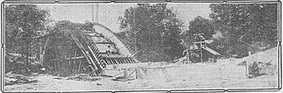
Buffalo Grove Lime Kiln is one of two old lime kilns in Illinois listed on the National Register of Historic Places. The other is the Griggsville Landing Lime Kiln in Pike County. Buffalo Grove Lime Kiln is located near the Ogle County city of Polo. When in use, the kiln would have produced raw quicklime. The lime kiln was added to the National Register in 2002.

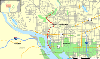
U.S. Route 29 (US 29) enters Washington, D.C., via the Key Bridge from Arlington County, Virginia, and exits at Silver Spring, Maryland. It predominantly follows city surface streets, although the portion of the route from the Key Bridge east to 26th Street Northwest is an elevated highway better known as the Whitehurst Freeway. The freeway, called the city's most ridiculed bridge in 1989, has survived several proposals for its demolition.

The Boulder Bridge is a historic bridge located in the Washington, D.C. portion of Rock Creek Park, an urban national park listed on the National Register of Historic Places.
The Cowell Lime Works, in Santa Cruz, California, was a manufacturing complex that quarried limestone, produced lime and other limestone products, and manufactured wood barrels for transporting the finished lime. Part of its area is preserved as the Cowell Lime Works Historic District, which was listed on the National Register of Historic Places in 2007. In addition to the four lime kilns, cooperage and other features relating to lime manufacture, the Historic District also includes other structures associated with the Cowell Ranch, including barns, a blacksmith shop, ranch house, cook house and workers' cabins. The 32-acre Historic District is located within the University of California, Santa Cruz campus, to either side of the main campus entrance.

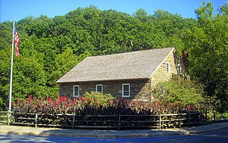
The Old Stone House is one of the oldest structures in Washington, D.C. The house is also the last pre-revolutionary colonial building in Washington, D.C. Built in 1765, Old Stone House is located at 3051 M Street, Northwest in the city's Georgetown neighborhood. Sentimental local folklore preserved the Old Stone House from being demolished, unlike many colonial homes in the area that were replaced by redevelopment.
The Olema Lime Kilns at Point Reyes National Seashore in California were built in 1850 on land leased from Mexican grantee Rafael Garcia by James A. Shorb and William F. Mercer, two San Francisco entrepreneurs. The kilns were reportedly fired only a few times, and have lain abandoned for some 140 years. They were apparently abandoned no later than 1855 after only a few firings, probably due to the poor quality, small limestone deposits and the financial depression of that year. They represent a Gold Rush era effort to establish a lime-producing industry in Marin County, only two years after cession of Alta California to the United States by Mexico. They consist of three long-abandoned, barrel-shaped stone vaults lying in ruins against a hillside on the east side of Olema Creek about five miles south of Olema and about 100 yards west of California State Highway 1.
Piney Branch is a tributary of Rock Creek in Washington, D.C. It is the largest tributary located entirely within the Washington city limits. It is spanned by the 16th Street Bridge, the country's first parabolic arch bridge.

The Milwaukee Falls Lime Company is the former owner of a limestone quarry and lime kilns located in Grafton, Wisconsin. It was added to the National Register of Historic Places in 2012. The quarry and kilns are now Lime Kiln Park, which also features a pavilion, playground, walking paths, sledding hill, horseshoe pits, and disc golf course.

The K Street Bridge is a complex of bridges over Rock Creek and the Rock Creek and Potomac Parkway in Washington, D.C. The lower level of the bridge carries the surface street K Street, while the upper level carries the Whitehurst Freeway which terminates and merges into K Street immediately east of the bridge. The central bridge is flanked by two flyover ramps that connect to the nearby terminus of Interstate 66.