Hawke's Bay, Newfoundland and Labrador

Last updated
Hawke's Bay
Town
Hawkesbay.JPG
Canada Newfoundland location map.svg
Red pog.svg
Hawke's Bay
Location of Hawke's Bay in Newfoundland
Coordinates: 50°36′50″N57°10′00″W / 50.61389°N 57.16667°W / 50.61389; -57.16667
Country Flag of Canada (Pantone).svg  Canada
Province Flag of Newfoundland and Labrador.svg  Newfoundland and Labrador
Settledearly 20th century
Population
 (2021)
  Total297
Time zone UTC-3:30 (Newfoundland Time)
  Summer (DST) UTC-2:30 (Newfoundland Daylight)
Area code 709
Highways NL Route 430.svg Route 430

Hawke's Bay is a town at the mouth of Torrent River southeast of Point Riche in the Canadian province of Newfoundland and Labrador.

Contents

History

The town was named after Edward Hawke by James Cook in 1766. This was to commemorate Hawke's victory in the Battle of Quiberon Bay in 1759. Although Hawke's Bay was used as an enclave during the early struggle for North America by both the English and French navies, it was not until the early 20th century that Michael Walsh became the first permanent settler. In 1903, a whaling station was established on the north side of the bay, but it closed the following year. Sydney Cotton ran the first airmail service in Newfoundland to Hawke's Bay. In 1933, pulpwood harvesting was established in the area by the International Pulp and Paper Company.

The first Postmistress was Miss Dorothea Desse Hoddinott who died in August 2003.

Climate

Hawke's Bay has a humid continental climate (Koppen: Dfb). Summers are mild and rainy while winters are chilly and extremely snowy, with average annual snowfall totaling 142 inches (360.5 cm). Winter typically begins during November and can last well into April, and can see nightly lows dip well below zero. [1]
Climate data for Hawke's Bay
MonthJanFebMarAprMayJunJulAugSepOctNovDecYear
Record high °C (°F)14.5
(58.1)
13.0
(55.4)
14.5
(58.1)
21.5
(70.7)
25.5
(77.9)
27.5
(81.5)
30.5
(86.9)
29.5
(85.1)
28.5
(83.3)
23.5
(74.3)
20.5
(68.9)
11.5
(52.7)
30.5
(86.9)
Average high °C (°F)−5.2
(22.6)
−5.2
(22.6)
−1.1
(30.0)
4.6
(40.3)
10.8
(51.4)
16.2
(61.2)
20.1
(68.2)
20.1
(68.2)
15.9
(60.6)
9.7
(49.5)
3.7
(38.7)
−1.5
(29.3)
7.4
(45.3)
Daily mean °C (°F)−9.6
(14.7)
−10.1
(13.8)
−5.4
(22.3)
0.8
(33.4)
6.2
(43.2)
11.4
(52.5)
15.5
(59.9)
15.6
(60.1)
11.5
(52.7)
6.1
(43.0)
0.6
(33.1)
−4.8
(23.4)
3.2
(37.8)
Average low °C (°F)−14.0
(6.8)
−14.9
(5.2)
−9.8
(14.4)
−3.0
(26.6)
1.6
(34.9)
6.5
(43.7)
10.8
(51.4)
11.1
(52.0)
7.2
(45.0)
2.5
(36.5)
−2.5
(27.5)
−7.9
(17.8)
−1.0
(30.2)
Record low °C (°F)−35.5
(−31.9)
−37.0
(−34.6)
−32.0
(−25.6)
−21.5
(−6.7)
−8.0
(17.6)
−1.5
(29.3)
1.5
(34.7)
1.0
(33.8)
−4.0
(24.8)
−6.0
(21.2)
−20.5
(−4.9)
−30.0
(−22.0)
−37.0
(−34.6)
Average precipitation mm (inches)107.1
(4.22)
82.3
(3.24)
59.6
(2.35)
48.7
(1.92)
61.8
(2.43)
80.1
(3.15)
102.8
(4.05)
94.4
(3.72)
102.0
(4.02)
97.0
(3.82)
82.4
(3.24)
92.1
(3.63)
1,010.2
(39.77)
Average rainfall mm (inches)6.8
(0.27)
6.8
(0.27)
7.9
(0.31)
20.9
(0.82)
57.4
(2.26)
79.5
(3.13)
102.8
(4.05)
94.4
(3.72)
102.2
(4.02)
94.3
(3.71)
59.8
(2.35)
17.1
(0.67)
649.7
(25.58)
Average snowfall cm (inches)100.3
(39.5)
75.4
(29.7)
51.7
(20.4)
27.8
(10.9)
4.4
(1.7)
0.5
(0.2)
0.0
(0.0)
0.0
(0.0)
0.0
(0.0)
2.7
(1.1)
22.6
(8.9)
75.0
(29.5)
360.5
(141.9)
Source: Environment Canada [2]

Demographics

In the 2021 Census of Population conducted by Statistics Canada, Hawke's Bay had a population of 297 living in 142 of its 162 total private dwellings, a change of

See also

Related Research Articles

Port Blandford is a town in eastern Newfoundland, Newfoundland and Labrador, Canada. It is in Division No. 7 on Clode Sound. The population in 1940 was 539, and increased to 631 by 1956.

<span class="mw-page-title-main">Bonavista, Newfoundland and Labrador</span> Town in Newfoundland and Labrador, Canada

Bonavista is a town on the Bonavista Peninsula, Newfoundland in the Canadian province of Newfoundland and Labrador. Unlike many Newfoundland coastal settlements, Bonavista was built on an open plain, not in a steep cove, and thus had room to expand to its current area of 31.5 km2 (12.2 sq mi). Bonavista is located approximately 300km from the provincial capital of St. John's.

<span class="mw-page-title-main">Corner Brook</span> City in Newfoundland and Labrador, Canada

Corner Brook is a city located on the west coast of the island of Newfoundland in the province of Newfoundland and Labrador, Canada. Corner Brook is the fifth largest settlement in Newfoundland and Labrador.

<span class="mw-page-title-main">Deer Lake, Newfoundland and Labrador</span> Town in Newfoundland and Labrador, Canada

Deer Lake is a town in the western part of the island of Newfoundland in the province of Newfoundland and Labrador, Canada.

<span class="mw-page-title-main">Nain, Newfoundland and Labrador</span> Inuit community in Newfoundland and Labrador, Canada

Nain is the northernmost permanent settlement in the Canadian province of Newfoundland and Labrador, within the Nunatsiavut region, located about 370 km (230 mi) by air from Happy Valley-Goose Bay. The town was established as a Moravian mission in 1771 by Jens Haven and other missionaries. As of 2021, the population is 1,204 mostly Inuit and mixed Inuit-European. Nain is the administrative capital of the autonomous region of Nunatsiavut.

<span class="mw-page-title-main">Cartwright, Newfoundland and Labrador</span> Town in Newfoundland and Labrador, Canada

Cartwright is a community located on the eastern side of the entrance to Sandwich Bay, along the southern coast of Labrador in the province of Newfoundland and Labrador, Canada. It was incorporated in 1956. Cartwright is the largest settlement in NunatuKavut.

Daniel's Harbour is a community on the west coast of Newfoundland, in the province of Newfoundland and Labrador. Its population as reported by the 2021 Census was 220 people. It has a reputation as a great place for wild whale sightings.

<span class="mw-page-title-main">Makkovik</span> Town in Newfoundland and Labrador, Canada

Makkovik is a town in Labrador in eastern Canada. It had 365 residents in 2021. The main industry is snow crabbing and there is a fishing cooperative.

Springdale is a town in Newfoundland and Labrador, Canada, which had a population of 2,965 people in 2021, up from 2,764 in the Canada 2006 Census. The community is located on the Northwestern shores of Hall's Bay in Central Newfoundland, near the mouth of Indian River.

<span class="mw-page-title-main">Woody Point, Newfoundland and Labrador</span> Town in Newfoundland and Labrador, Canada

Woody Point is a town located in the heart of Gros Morne National Park, on the western coast of Newfoundland. Situated on Bonne Bay, the Town of Woody Point encompasses three areas: Curzon Village, Woody Point and Winterhouse Brook. It has a total population of 244 residents. Woody Point is a Registered Heritage District and has a waterfront with many heritage buildings and four Registered Newfoundland and Labrador Heritage Structures. The community is served by Route 431.

<span class="mw-page-title-main">Burgeo</span> Town in Newfoundland and Labrador, Canada

Burgeo is a town in the Canadian province of Newfoundland and Labrador. It is located mainly on Grandy Island, on the south coast of the island of Newfoundland. It is an outport community.

Renews–Cappahayden is a small fishing town on the southern shore of Newfoundland, 83 kilometres (52 mi) south of St. John's.

Colinet is an incorporated town located on the northwest arm of St. Mary's Bay in Newfoundland and Labrador, Canada.

<span class="mw-page-title-main">Comfort Cove-Newstead</span> Town in Newfoundland and Labrador, Canada

Comfort Cove-Newstead is a small fishing community located outside Campbellton, on the east coast of Newfoundland and Labrador, Canada,.

<span class="mw-page-title-main">Logy Bay-Middle Cove-Outer Cove</span> Town in Newfoundland and Labrador, Canada

Logy Bay-Middle Cove-Outer Cove is a town in the Canadian province of Newfoundland and Labrador. It is located within a 10 minutes' drive from downtown St. John's preceding the Town of Torbay on the eastern tip of the Avalon Peninsula.

Main Brook is a town in the Canadian province of Newfoundland and Labrador. The town had a population of 246 in the Canada 2021 Census.

St. Mary's is a town in the Canadian province of Newfoundland and Labrador. The town had a population of 313 in the Canada 2021 Census.

Winterland is a town in the Canadian province of Newfoundland and Labrador. The town is considered to be a bedroom community of Marystown.

Flower's Cove is a town in the Canadian province of Newfoundland and Labrador. The town had a population of 272 in the Canada 2021 Census. It is known for its thrombolite fossils.

<span class="mw-page-title-main">Fogo Island, Newfoundland and Labrador</span> Town in Newfoundland and Labrador, Canada

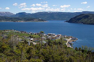
Fogo Island is a town located on Fogo Island, the largest of the offshore islands in the province of Newfoundland and Labrador, Canada.

References

  1. Canada, Environment and Climate Change (2013-09-25). "Canadian Climate Normals 1981-2010 Station Data - Climate - Environment and Climate Change Canada". climate.weather.gc.ca. Retrieved 2020-05-28.
  2. "Hawke's Bay". Canadian Climate Normals 1981–2010 (in English and French). Environment Canada. Retrieved September 1, 2015.
  3. "Population and dwelling counts: Canada, provinces and territories, census divisions and census subdivisions (municipalities), Newfoundland and Labrador". Statistics Canada. February 9, 2022. Retrieved March 15, 2022.

Coordinates: 50°36′50″N57°10′00″W / 50.61389°N 57.16667°W / 50.61389; -57.16667