Kaas Plateau | |
---|---|
IUCN category IV (habitat/species management area) | |
Kaas Plateau | |
Location | Satara, Maharashtra, India |
Nearest city | Satara, Pune, Kolhapur |
Coordinates | 17°43′12″N73°49′22″E / 17.72000°N 73.82278°E Coordinates: 17°43′12″N73°49′22″E / 17.72000°N 73.82278°E |
Area | 10 km2 (3.9 sq mi) |
Governing body | Ministry of Environment and Forests, Government of India |
www | |
Official name | Natural Properties - Western Ghats (India) |
Type | Natural |
Criteria | ix, x |
Designated | 2012 (36th session) |
Reference no. | 1342 |
State Party | India |
Region | Indian subcontinent |
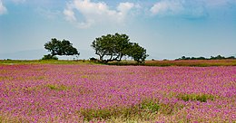
The Kaas Plateau, also known as the Kaas Pathar, is a plateau situated 25 kilometres west from Satara city in Maharashtra, India. [1] It falls under the Sahyadri Sub Cluster of the Western Ghats, and it became a part of a UNESCO World Natural Heritage Site in 2012. [2] [3]
It is a biodiversity hotspot known for various types of seasonal wild flowers bloom and numerous species of endemic butterflies annually in the months of August and September. [3] The plateau is situated at an altitude of 1200 metres and is approximately 10 square kilometers in area. Kaas has more than 850 different species of flowering plants.These include orchids, shrubs such as the Karvy, and carnivorous plants such as Drosera Indica. Kaas Pathar is a plateau made from volcanic rocks in the Satara district of Maharashtra, and comes under the biosphere of the Western Ghats. The flora of kaas i.e. the entire flowering plants and their related plants are typically restricted to that particular locality only.This is because the plateau is largely formed of basalt which is directly exposed to atmosphere.The basalt is almost covered entirely by a thin cover of soil formed due to erosion and has accumulated a layer of not more than an inch or so.
Kaas plateau is a plateau located near Satara. It is situated high hill plateaus and grasslands turns into a 'valley of flowers' during monsoon season, particularly from August to early October. Kaas Plateau has more than 150 or more types of flowers, shrubs and grasses. The orchids bloom here for a period of 3–4 weeks during this season. Kaas plateau is a World Natural Heritage site, part of the Sahyadri Sub-cluster. [4] [5] [6] To control possible damage by tourists, the number of visitors to the plateau has been restricted to 3,000 per day. [4] [7] In September, some of the most common flowering plants are Eriocaulon spp., Utricularia spp., Pogostemon deccanensis, Senecio grahamii, Impatiens lawii and Dipcadi montanum. [8]
The plateau experiences a natural cycle of extreme conditions, with wet water-logged cool monsoons, very dry hot summer (45 °C) and dry winter (5 °C). The soil is acidic only a thin layer on top of laterite rock underneath. Extreme seasonality influences the ecology of the site.
Kaas plateau is a plateau located around 25 km from Satara. There are two ways to reach Kaas. one the more direct way from Satara and another from Tapola via the link road connecting Mahabaleshwar and Panchgani to Kas Pathar. Kas plateau is 20 km away from Northern part of Koyana Sanctuary. The major portion of the plateau is reserve Forest. Kaas lake (built 100 years ago) is a perennial source of Water supply for western part of Satara city by gravity. The flora of Kaas are around the locality of that area. The plateau is largely formed of basalt which is directly exposed to atmosphere. The basalt rock is covered by a thin cover of soil formed due to erosion and has accumulated a layer of not more than an inch or so. This soil is neither black nor lateritic. At certain places water gets accumulated because of uneven surface. The plants growing on Kas plateau are typically of herbaceous nature of like grasses. The small shrubs and trees are located at the periphery of the plateau at Kaas plateau. [7] The small shrubs and trees are located at the periphery of the plateau.
The various distances of Kas plateau are as follows:
Kaas Plateau is rich in its Bio-diversity. Many species are observed on plateau which are new to the Botanical Science. Many of the endemic, endangered plants are found on Plateau. More than 850 species of flowering plants are reported on the plateau. 624 species have entered in the Red Data Book. Out of these 624 species, 39 are found only in Kaas Region. [9]
The main plateau of Kas has been surveyed in detail by many researchers. The other three plateaus have not been surveyed. Earliest work on the plateau was by Chavan et al. (1973). [10] Dr. Bachulkar studied endemic flora of this area. Bhattarai et al. 2012 [11] has identified 103 species of local concern on the Kas plateau and surrounding area. Lekhak and Yadav, 2012 [12] have documented floristic wealth of the Kas plateau.
The vegetation and biodiversity values of the Kas plateau as a representative site of the threatened rocky plateau habitat has been discussed by Porembski and Watve (2005) [13] Watve (2007), [14] 2010 [15] One study has been published on the pollination mechanism (Hobbhahn et al., 2006 [16] that includes field studies carried out on Kas.
A list of lichen species from Kas area has been compiled by Dr. Gayatri Chitale & Archana Dube during their doctoral studies from Maharashtra which includes 14 species of macro lichens and 6 species of micro lichens found on Kas plateau.
Chikane and Bhosale (2012) [17] have compiled herpetofaunal list of the Kas area including 57 species.Photo documentation of spiders from Kas is available with Vishal Deshpande, Ranwata. List of birds (about 200+ species) has been compiled by Vikram Hoshing, Sanjay Thakur and many other bird watchers of the area. Fishes of Kas area are studied by Sunil Bhoite and Dr. Neelesh Dahanukar. Although a list of invertebrates has not been compiled, Dr. Hemant Ghate (Modern College, Shivajinagar, Pune) and his students have been recording faunal diversity of Kas for more than a decade. The pond has also been studied for microfossils by the Department of Geology, Agharkar Research Institute.
Many popular books have appeared in Marathi and English, including photoguides by Shrotri (2007), [18] Shrikant Ingalhallikar (Flowers of Kas 2012), and another by Satara Forest department in 2012.
Herbaceous plant communities of this plateau were systematically surveyed during 2004-2006 as a part of Department of Science and Technology funded project on plant communities of rocky plateaus. In a sampling area of 25 sq.m, H’ =3.88 and 40 herbaceous species were reported in September 2004, followed by H’ =3.971 and 29 herbaceous species in September 2005, indicating rich herbaceous diversity. [14]
Kas is type locality of following species
Flowering plant:
Insects (Beetle): A new genus:
A new genus & species:
In addition to this, following species have been rediscovered from Kas
Snake:
Kas is very famous for the mass blooming of Eriocaulon spp., Utricularia spp., Impatiens lawii and Smithia spp. All the typical microhabitats and species complexes of lateritic plateau are seen here.
The plateau also has several invertebrates throughout the year. Tiger beetles are observed mating in large numbers on Kas during September–October. Praying mantises, ants are common. Tadpole shrimps were reported some years back. Fairy shrimps are present in the small pond. The plateau has several signs of presence of barking deers, hares, civets and rodents. Gaur has been reported by Sunil Bhoite from Satara in 2012. Ruddy mongoose, Rusty spotted cat have been observed in surrounding scrub area. Presence of Leopard has been reported from the surrounding forest area. Endemic Malabar Lark is commonly observed nesting on the rocky plateau. [25]
Kaas lake is on the south of the Kaas Plateau and is surrounded by dense forest. It lies between Sajjangad fort and the Kanher Dam. Koyna project is around 30 km towards the south of Kaas Lake. [26] Vajrai Waterfall is also near from Kaas which is one of India's highest waterfalls. [27]
The following is a list of some of the flowers found on at Kaas:
[[
]]
The plateau was always under local pressures of grazing and burning. Domestic cattle compete to a certain extent with wild mammals. Disturbance was also caused by the road that passes through the plateau. Many road kills of snakes have been reported. Addition of dung leads to eutrophication. Heavy trampling by cattle and people has created many paths on the plateau. It is not possible to judge the impact of these activities on the plateau diversity, as no baseline data is available. Recent popularity and sudden growth in tourism are at present the most serious threats, not only to the plateau but also to the surrounding areas. The alarming rise in the number of tourists became a serious concern since 2008. The easily visible ecological impacts of tourism are high levels of vegetation trampling, microhabitat damage and solid waste problem. [28] The not so easily visible impacts are changing land-use in surrounding area, socio-economic and cultural changes in the surrounding villages. Both these are irreversible unless immediate measures are taken. A Joint Forest Management Committee has been constituted to manage tourist inflow. The most serious threat is establishment of invasive weeds, which are introduced through foreign soils and can compete with the indigenous flora.
Wikimedia Commons has media related to Kaas plateau . |
The Western Ghats, also known as Sahyadri, are a mountain range that covers an area of 140,000 square kilometres (54,000 sq mi) in a stretch of 1,600 kilometres (990 mi) parallel to the western coast of the Indian peninsula, traversing the states of Kerala, Tamil Nadu, Karnataka, Goa, Maharashtra and Gujarat. It is a UNESCO World Heritage Site and is one of the eight "hottest hot-spots" of biological diversity in the world. It is sometimes called the Great Escarpment of India. It contains a large proportion of the country's flora and fauna, many of which are only found in India and nowhere else in the world. According to UNESCO, the Western Ghats are older than the Himalayas. They influence Indian monsoon weather patterns by intercepting the rain-laden monsoon winds that sweep in from the south-west during late summer. The range runs north to south along the western edge of the Deccan Plateau, and separates the plateau from a narrow coastal plain, called Konkan, along the Arabian Sea. A total of thirty-nine areas in the Western Ghats, including national parks, wildlife sanctuaries and reserve forests, were designated as world heritage sites in 2012 – twenty in Kerala, ten in Karnataka, five in Tamil Nadu and four in Maharashtra.
Satara is a city located in the Satara District of Maharashtra state of India, near the confluence of the river Krishna and its tributary, the Venna. The city was established in the 16th century and was the seat of the Raja of Satara, Chhatrapati Shahu. It is the headquarters of Satara Tehsil, as well as the Satara District. The city gets its name from the seven forts (Sat-Tara) which are around the city.
The Eriocaulaceae are a family of monocotyledonous flowering plants in the order Poales, commonly known as the pipewort family. The family is large, with about 1207 known species described in seven genera. They are widely distributed, with the centers of diversity for the group occurring in tropical regions, particularly the Americas. Very few species extend to temperate regions, with only 16 species in the United States, mostly in the southern states from California to Florida, only two species in Canada, and only one species in Europe. They tend to be associated with wet soils, many growing in shallow water. This is also reported from the southern part of India and the regions of Western Ghats hot spots.
Madayi. is a village near Pazhayangadi in Kannur district, Kerala. The famous Bhagavathy shrine, Madayi Kavu where devotees worship Bhadrakali is located here. The Goddess is one of the family deity of the Chirakkal Royal family, and the temple is known for the Koyikalasham. The temple was one of the few to survive desecration by the armies of Tippu Sultan, which devotees attribute to the grace of the Goddess. The Kolathiri Rajahs were the administrators of the temple, however recently the administration was transferred to the Malabar Devaswom Board. Nearby is the Vadukunnu Temple dedicated to Shiva. The temple was razed by followers of Tippu Sultan in the 18th century, but the temple has been rebuilt and is a vibrant centre of religion in the region.
Koyna Wildlife Sanctuary is a wildlife sanctuary and natural World Heritage Site, which is located in Satara district of the Indian state of Maharashtra. The sanctuary is nested in the Western Ghats, covering an area of around 423.55 km2 (163.53 sq mi), and elevations ranging from 600 to 1,100 m. It was notified in 1985 as a wildlife sanctuary situated in Maharashtra. It forms the northern portion of the Sahyadri Tiger Reserve, with Chandoli National Park forming the southern part of the reserve.
Indotyphlus maharashtraensis is a species of caecilians described in 2004 by scientists of Bombay Natural History Society and the Natural History Museum, London. It is only the second species of Indotyphlus known to science, and only known from its type locality near Humbarli village, Satara District, in the Western Ghats of Maharashtra, India. Common names Humbarli caecilian, Maharashtra caecilian, and Konkan tail-less caecilian have been coined for it.
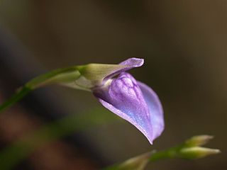
Utricularia babui is a perennial carnivorous plant that belongs to the genus Utricularia. It is native to India and had only been collected from the Kolhapur district at the time of its description in 2005. U. babui grows as a terrestrial plant in and near small streams in open forests at altitudes from 700 m (2,297 ft) to 900 m (2,953 ft). Specimens of U. babui were previously mistaken for U. graminifolia. It was originally described and published by Shrirang Ramchandra Yadav, M. M. Sardesai, and S. P. Gaikwad in 2005.
Glyphochloa is a genus of Indian plants in the grass family.
Frerea is a plant genus which contains only one species, Frerea indica, a small succulent native to the forest area in the Western Ghats and Deccan plateau in Maharashtra state in India. It is also grown as a greenhouse plant by succulent plant enthusiasts. At one time, it was on the IUCN list of twelve most endangered species on earth, but conservation efforts have brought it back from the brink of extinction.
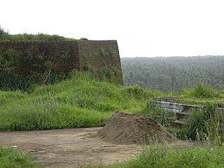
Madayipara is a flat topped hillock located in the Madayi, of Kannur district of Kerala state in the Southern India. It is overlooking Payangadi town on the northern bank of Kuppam river.
Cnemaspis girii, also known as Giri's day gecko, is a species of geckos in the genus Cnemaspis described in 2014. The species, found in the forests of the Kaas plateau in Satara district, Maharashtra, India, was discovered by researchers from Bangalore's National Centre for Biological Sciences (NCBS) and Centre for Ecological Sciences (CES). The gecko lives under rocks and hollowed out trees near water bodies within its range.
Eriocaulon bolei is a critically endangered monocotyledonous plant only recorded in Satara district in the state of Maharashtra, India. It is a herb which grows up to 10–20 cm in height and seen in running water.
Eriocaulon ratnagiricum is a critically endangered monocotyledonous plant only recorded near Ratnagiri in the state of Maharashtra, India. It is a small annual which grows on the edges of temporary pools on lateritic plateaus.
Eriocaulon santapaui is a critically endangered monocotyledonous plant endemic to the Western Ghats around Khandala and Pune in the state of Maharashtra, India.
Surekha Yadav née Surekha Shankar Yadav is a female locopilot of the Indian Railways in India,. She became India's first female train driver in 1988. She drove the first "Ladies Special" local train for Central Railways when it was first introduced in the four metro cities by Mamata Banerjee the then Railway Minister, in April 2000. A momentous event in her career was on 8 March 2011, on the International Women's Day, when she became Asia's first woman train driver to drive the Deccan Queen from Pune to CST, through difficult but scenic topography, where she was greeted by the then Mayor of Mumbai Shraddha Jadhav, at CST, the headquarter of Central Railway zone. It was Surekha's dream-come-true as she drove one of the prestigious trains of the Central Railway, which carries the female of name; the Mumbai-Pune Railway Pravasi Sangh (association) strongly supported her to run this train. However, a commonly heard comment on her driving is that "Women don't drive railway engines'".
Ninam is a census village in Satara district, in the Indian state of Maharashtra. It is a village surrounded by greenery and farms but also mountains. Agriculture is the main land use in the village with more than 75% of the total area being used for agricultural activities. The village close to historic Ajinkyatara fort, which is to the north. The large Jyotirlinga temple is in the center of the village.
Habenaria panchganiensis is a species of orchid that is native to western India. This beautiful orchids found at high attitude hills of Kaas plateau and Panchagani Mahabaleshwar. The flower blooms in 5/6 petals of flowers and looks very attractive.
Khambatki Ghat is a mountain pass on Pune-Kolhapur section of National Highway 48 in Maharashtra, India. This ghat lies in the Sahyadri mountain ranges and has picturesque mountain-scapes and a pleasant climate.
The Masai Plateau, also known as the Masai Pathar or Masai Sadas, is a plateau situated 30 kilometers west from Kolhapur city in Maharashtra.
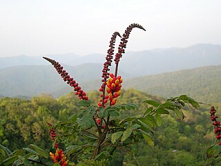
Moullava spicata is an endemic species of creeper found in the Western Ghats of India.