Lingunan

Last updated
Lingunan
Lingunan, Valenzuela, Metro Manila Locator.png
Lingunan (red) with its first congressional co-barangays (light red) in Valenzuela
Philippines location map (Luzon).svg
Red pog.svg
Lingunan
Lingunan (Luzon)
Philippines location map (square).svg
Red pog.svg
Lingunan
Lingunan (Philippines)
Coordinates: 14°43′7″N120°58′34″E / 14.71861°N 120.97611°E / 14.71861; 120.97611
Government
   Barangay Captain [1] Jose Trinidad Cabral
   Sangguniang Kabataan Chairperson Caryl Anne Ramos Race
Area
  Total1.59 km2 (0.61 sq mi)
Elevation
[2]
10 m (30 ft)
Highest elevation
33 m (108 ft)
Lowest elevation
−3 m (−10 ft)
Population
 (2020) [3]
  Total24,088
  Density15,000/km2 (39,000/sq mi)
Time zone UTC+8 (PST)
Postal code
1446
Area code 02

Lingunan is a landlocked 1st congressional district urban barangay in Valenzuela City, Philippines. It borders the barangays Viente Reales to the west, Canumay West to the east, Lawang Bato to the north-east and the city of Meycauayan which its barangays Lawa and Caingin borders it to the north. Based on the 2020 census, it has a population of 24,088. [3]

Contents

Etymology

The name of the barangay came from the story of which a little girl whose name is "Lingap" living in a barrio. Later on, Spaniards arrived to conquer the barrio and people started to left. When Lingap's family is trying to leave, they forgot the pillow with jewelries inside of it. They were spotted by Spaniards. Lingap's dad shouted, "Lingap, ang unan!" The Spaniards misheard it as "lingunan" and ask them in Spanish, but they didn't understand the Spaniards and are afraid of them so they left. The conquered barrio is now named by Spaniards as "Lingunan". [4]

History

During the Spanish and American occupation, the place was a thriving agricultural area. [4]

Geography

Lingunan is located about 14 kilometers north of Manila in the coordinates 14°43′7″N120°58′34″E / 14.71861°N 120.97611°E / 14.71861; 120.97611 .

It has an enclosed creek named Lingunan Creek, which in 2021 is the most improved estero by Department of Environment and Natural Resources (DENR) in Metro Manila. [5] [6] Its surrounding rivers are found on its border with Bulacan and on its border with Barangay Viente Reales.

Climate

The Köppen-Geiger climate classification of Lingunan is Tropical Monsoon (Am) which has less pronounce dry seasons or extraordinary rainy wet seasons and pronounce dry seasons.[ citation needed ]

Population

Lingunan
YearPop.±%
1990 6,884    
1995 12,040+74.9%
2000 11,875−1.4%
2007 14,661+23.5%
2010 17,436+18.9%
2015 21,217+21.7%
2020 24,088+13.5%
Source: Philippine Statistics Authority [7] [8] [9] [10] [11] [12] [3]

Related Research Articles

<span class="mw-page-title-main">Caloocan</span> Highly urbanized city in Metro Manila, Philippines

Caloocan, officially the City of Caloocan, is a 1st class highly urbanized city in Metro Manila, Philippines. According to the 2020 census, it has a population of 1,661,584 people making it the fourth-most populous city in the Philippines.

<span class="mw-page-title-main">Valenzuela, Metro Manila</span> Highly urbanized city in Metro Manila, Philippines

Valenzuela, officially the City of Valenzuela, is a 1st class highly urbanized city in the National Capital Region of the Philippines. According to the 2020 census, it has a population of 714,978 people.

<span class="mw-page-title-main">Navotas</span> Highly urbanized city in Metro Manila, Philippines

Navotas, officially the City of Navotas, is a 1st class highly urbanized city in the National Capital Region of the Philippines. According to the 2020 census, it has a population of 247,543 people.

<span class="mw-page-title-main">Narvacan</span> Municipality in Ilocos Sur, Philippines

Narvacan, officially the Municipality of Narvacan, is a 2nd class municipality in the province of Ilocos Sur, Philippines. According to the 2020 census, it has a population of 46,234 people.

<span class="mw-page-title-main">Guinobatan</span> Municipality in Albay, Philippines

Guinobatan, officially the Municipality of Guinobatan, is a 1st class municipality in the province of Albay, Philippines. According to the 2020 census, it has a population of 85,786 people.

<span class="mw-page-title-main">Masbate City</span> Capital of Masbate, Philippines

Masbate City, officially the City of Masbate, is a 4th class component city and capital of the province of Masbate, Philippines. According to the 2020 census, it has a population of 104,522 people.

<span class="mw-page-title-main">Alfonso, Cavite</span> Municipality in Cavite, Philippines

Alfonso, officially the Municipality of Alfonso, is a 1st class municipality in the province of Cavite, Philippines. According to the 2020 census, it has a population of 59,306 people.

<span class="mw-page-title-main">Pio Duran</span> Municipality in Albay, Philippines

Pio Duran, officially the Municipality of Pio Duran, is a 3rd class municipality in the province of Albay, Philippines. According to the 2020 census, it has a population of 49,070 people.

<span class="mw-page-title-main">Caoayan</span> Municipality in Ilocos Sur, Philippines

Caoayan, officially the Municipality of Caoayan, is a 4th class municipality in the province of Ilocos Sur, Philippines. According to the 2020 census, it has a population of 19,574 people.

<span class="mw-page-title-main">Jalajala</span> Municipality in Rizal, Philippines

Jalajala, officially the Municipality of Jalajala, is a 4th class municipality in the province of Rizal, Philippines. According to the 2020 census, it has a population of 34,017 people, making it the least populated municipality in the province.

<span class="mw-page-title-main">General Emilio Aguinaldo, Cavite</span> Municipality in Cavite, Philippines

General Emilio Aguinaldo, officially the Municipality of General Emilio Aguinaldo, is a 5th class municipality in the province of Cavite, Philippines. According to the 2020 census, it has a population of 23,973 people.

<span class="mw-page-title-main">Calaca, Batangas</span> Component city in Batangas, Philippines

Calaca, officially the City of Calaca, is a component city in the province of Batangas, Philippines. According to the 2020 census, it has a population of 87,361 people.

<span class="mw-page-title-main">Lemery, Batangas</span> Municipality in Batangas, Philippines

Lemery, officially the Municipality of Lemery, is a 1st class municipality in the province of Batangas, Philippines. According to the 2020 census, it has a population of 93,186 people.

<span class="mw-page-title-main">Pio V. Corpus</span> Municipality in Masbate, Philippines

Pio V. Corpus, officially the Municipality of Pio V. Corpus is a 4th class municipality in the province of Masbate, Philippines. According to the 2020 census, it has a population of 23,744 people.

<span class="mw-page-title-main">Guiguinto</span> Municipality in Bulacan, Philippines

Guiguinto, officially the Municipality of Guiguinto, is a 1st class municipality in the province of Bulacan, Philippines. According to the 2020 census, it has a population of 113,415 people. It is 34 kilometers (21 mi) from Manila and 11 kilometers (6.8 mi) from Malolos City.

<span class="mw-page-title-main">San Ildefonso, Bulacan</span> Municipality in Bulacan, Philippines

San Ildefonso, officially the Municipality of San Ildefonso is a 1st class municipality in the province of Bulacan, Philippines. According to the 2020 census, it has a population of 115,713 people.

<span class="mw-page-title-main">Lawang Bato</span> Barangay in Valenzuela City, Metro Manila, Philippines

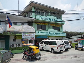
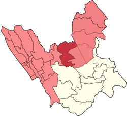
Lawang Bato is a barangay in Valenzuela, Metro Manila, Philippines. The name "Lawang Bato" came from the once rocky land where the barangay once stood.

<span class="mw-page-title-main">Carmona, Makati</span> Barangay in Makati City, Metro Manila, Philippines

Carmona is one of the 23 barangays of Makati. It is located in the northern part of the city. It is a residential area with a population of 2,745 as of the 2020 census, making it the least populous barangay in the city. The barangay was named after Comandante Isidro Carmona, a Filipino soldier who fought during the Philippine Revolution against the Spaniards.

<span class="mw-page-title-main">Santo Niño, Parañaque</span> Barangay in Parañaque City, Metro Manila, Philippines

Santo Niño is an administrative division in southern Metro Manila, the Philippines. It is a barangay in the city of Parañaque immediately surrounding Ninoy Aquino International Airport on its west and south sides. A large portion of the village extends into the property of the airport grounds to include Terminal 1 as well as the western half of Runway 06/24. The village has a total land area of 245.97 hectares of which about 55% is occupied by the airport complex. Its population is concentrated in the areas along the Estero de Tripa de Gallina.

References

  1. PIO, Administrator, Team. "Punong Barangay Directory". City Government of Valenzuela. Retrieved 2024-03-10.{{cite web}}: CS1 maint: multiple names: authors list (link)
  2. "Carte topographique Lingunan, altitude, relief". Cartes topographiques (in French). Retrieved 2024-03-10.
  3. 1 2 3 "2020 Census of Population by City and Barangay". Philippine Statistics Authority . Retrieved 2024-03-28.
  4. 1 2 PIO, Administrator, Team. "Lingunan". City Government of Valenzuela. Retrieved 2024-03-28.{{cite web}}: CS1 maint: multiple names: authors list (link)
  5. Manila, RadyoMaN (2021-03-09). "Lingunan Creek sa Valenzuela City, itinanghal na most improved estero sa Metro Manila ng DENR sa katatapos na Gawad Taga-Ilog - RMN Networks". RMN Networks. Retrieved 2024-04-23.
  6. PIO, Administrator, Team. "Valenzuela City". City Government of Valenzuela. Retrieved 2024-04-23.{{cite web}}: CS1 maint: multiple names: authors list (link)
  7. "1990 Census of Population by City and Barangay" (PDF). Philippine Statistics Authority . Retrieved March 25, 2024.
  8. "1995 Census of Population by City and Barangay" (PDF). Philippine Statistics Authority . Retrieved 2024-03-25.
  9. "2000 Census of Population by City and Barangay" (PDF). Philippine Statistics Authority . Retrieved 2024-03-25.
  10. Philippine Statistics Authority. "2007 Census of Population by City and Barangay". Scribd. Archived from the original on 2024-03-25. Retrieved 2024-03-25.
  11. "2010 Census of Population in Philippines". Philippine Statistics Authority . Retrieved 2024-03-25.
  12. "2015 Census of Population by City and Barangay" (PDF). Philippine Statistics Authority . Retrieved 2024-03-28.