Marks, Mississippi

Last updated
Marks, Mississippi
Marks Welcome Sign.jpg
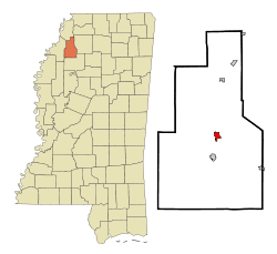
Quitman County Mississippi Incorporated and Unincorporated areas Marks Highlighted.svg
Location of Marks, Mississippi
Usa edcp location map.svg
Red pog.svg
Marks, Mississippi
Location in the United States
Coordinates: 34°15′18″N90°16′22″W / 34.25500°N 90.27278°W / 34.25500; -90.27278 Coordinates: 34°15′18″N90°16′22″W / 34.25500°N 90.27278°W / 34.25500; -90.27278
Country United States
State Mississippi
County Quitman
Area
[1]
  Total1.28 sq mi (3.32 km2)
  Land1.28 sq mi (3.32 km2)
  Water0.00 sq mi (0.00 km2)
Elevation
161 ft (49 m)
Population
 (2020)
  Total1,444
  Density1,125.49/sq mi (434.69/km2)
Time zone UTC-6 (Central (CST))
  Summer (DST) UTC-5 (CDT)
ZIP code
38646
Area code 662
FIPS code 28-45240
GNIS feature ID0673138

Marks is a city in and the county seat of Quitman County, Mississippi. [2] As of the 2010 census, the city population was 1,735.

Contents

History

The town of Marks was named after Leopold Marks (1851-1910) who left Germany to avoid conscription by the German army. He arrived in New York in 1868. Marks, a Jew, became Quitman County's first representative to the state legislature and served for eight years. He encouraged the Yazoo and Mississippi Valley Railroad to come to the area by giving the railroad company, without cost, the right-of-way through his plantation plus 10 acres (40,000 m2) of land. Leopold Marks' son Henry donated land to the town to be used as a cemetery. [3]

The official "founding" of the town is considered to be May 12, 1907; on May 12, 2007, the town celebrated its centennial.[ citation needed ]

On September 26, 1913 a black man named Walter Brownloe, accused of attacking a white farmer's wife, was taken from the town prison by a mob and hanged. [4]

Marks was the starting point of Dr. Martin Luther King Jr's Poor People's Campaign in 1968. [5]

Amtrak's City of New Orleans began stopping at Marks on April 4, 2018. A new station was built for passengers to get on or get off. [6]

Geography

According to the United States Census Bureau, the city has a total area of 1.0 square mile (2.6 km2), all land.

Climate

Climate data for Marks, Mississippi
MonthJanFebMarAprMayJunJulAugSepOctNovDecYear
Record high °F (°C)86
(30)
84
(29)
90
(32)
94
(34)
101
(38)
107
(42)
108
(42)
109
(43)
107
(42)
97
(36)
93
(34)
81
(27)
109
(43)
Average high °F (°C)49
(9)
55
(13)
64
(18)
73
(23)
81
(27)
89
(32)
92
(33)
91
(33)
85
(29)
76
(24)
63
(17)
53
(12)
73
(23)
Average low °F (°C)31
(−1)
34
(1)
42
(6)
50
(10)
60
(16)
68
(20)
71
(22)
69
(21)
62
(17)
50
(10)
41
(5)
34
(1)
51
(11)
Record low °F (°C)−8
(−22)
0
(−18)
13
(−11)
29
(−2)
34
(1)
48
(9)
52
(11)
52
(11)
36
(2)
26
(−3)
13
(−11)
−2
(−19)
−8
(−22)
Average precipitation inches (mm)4.98
(126)
4.51
(115)
5.64
(143)
5.08
(129)
5.71
(145)
4.97
(126)
3.85
(98)
2.95
(75)
3.14
(80)
3.22
(82)
5.26
(134)
5.50
(140)
54.81
(1,392)
Average snowfall inches (cm)0.4
(1.0)
0.2
(0.51)
0.1
(0.25)
0
(0)
0
(0)
0
(0)
0
(0)
0
(0)
0
(0)
0
(0)
0
(0)
0.2
(0.51)
0.9
(2.3)
Source: [7]

Demographics

Historical population
CensusPop.Note
1910 670
1920 1,02052.2%
1930 1,25823.3%
1940 1,81844.5%
1950 2,20921.5%
1960 2,57216.4%
1970 2,6091.4%
1980 2,260−13.4%
1990 1,758−22.2%
2000 1,551−11.8%
2010 1,73511.9%
2020 1,444−16.8%
U.S. Decennial Census [8]

2020 census

Marks racial composition [9]
RaceNum.Perc.
White (non-Hispanic)38126.39%
Black or African American (non-Hispanic)1,03171.4%
Asian 40.28%
Other/Mixed 231.59%
Hispanic or Latino 50.35%

As of the 2020 United States census, there were 1,444 people, 699 households, and 425 families residing in the city.

2000 census

As of the census [10] of 2000, there were 1,551 people, 579 households, and 387 families residing in the city. The population density was 1,509.9 inhabitants per square mile (583.0/km2). There were 643 housing units at an average density of 625.9 per square mile (241.7/km2). The racial makeup of the city was 34.62% White, 64.67% African American, 0.06% Native American, 0.19% Asian, and 0.45% from two or more races. Hispanic or Latino of any race were 0.39% of the population.

There were 579 households, out of which 33.0% had children under the age of 18 living with them, 32.0% were married couples living together, 29.2% had a female householder with no husband present, and 33.0% were non-families. 29.7% of all households were made up of individuals, and 13.0% had someone living alone who was 65 years of age or older. The average household size was 2.55 and the average family size was 3.16.

In the city, the population was spread out, with 28.7% under the age of 18, 8.4% from 18 to 24, 26.8% from 25 to 44, 16.7% from 45 to 64, and 19.3% who were 65 years of age or older. The median age was 35 years. For every 100 females, there were 81.6 males. For every 100 females age 18 and over, there were 73.1 males.

The median income for a household in the city was $20,521, and the median income for a family was $27,153. Males had a median income of $25,100 versus $16,985 for females. The per capita income for the city was $11,104. About 26.1% of families and 30.3% of the population were below the poverty line, including 39.9% of those under age 18 and 27.7% of those age 65 or over.

Education

The City of Marks is served by the Quitman County School District.

Delta Academy, a private school, is in Marks. [11]

Notable people

Related Research Articles

<span class="mw-page-title-main">Tallahatchie County, Mississippi</span> County in Mississippi, United States

Tallahatchie County is a county in the U.S. state of Mississippi. At the 2020 census, the population was 12,715. Its county seats are Charleston and Sumner.

<span class="mw-page-title-main">Sharkey County, Mississippi</span> County in Mississippi, United States

Sharkey County is a county located in the U.S. state of Mississippi. Part of the eastern border is formed by the Yazoo River. According to the 2020 census, the population was 3,800, making it the second-least populous county in Mississippi, after Issaquena County. Its county seat is Rolling Fork. The county is named after William L. Sharkey, the provisional Governor of Mississippi in 1865.

<span class="mw-page-title-main">Quitman County, Mississippi</span> County in Mississippi, United States

Quitman County is a county located in the U.S. state of Mississippi. As of the 2020 census, the population was 6,176, making it the third-least populous county in Mississippi. Its county seat is Marks. The county is named after John A. Quitman, Governor of Mississippi from 1835 to 1836 and from 1850 to 1851.

<span class="mw-page-title-main">Coahoma County, Mississippi</span> County in Mississippi, United States

Coahoma County is a county located in the U.S. state of Mississippi. As of the 2020 census, the population was 21,390. Its county seat is Clarksdale.

<span class="mw-page-title-main">Quitman County, Georgia</span> County in Georgia, United States

Quitman County is a county located in the southwestern part of the U.S. state of Georgia. As of the 2020 census, the population was 2,235, making it the second-least populous county in Georgia. The county seat is Georgetown. The county was created on December 10, 1858, and named after General John A. Quitman, leader in the Mexican–American War, and once Governor of Mississippi. In November 2006, residents voted to consolidate the city government of Georgetown and the county government of Quitman into a consolidated city-county.

<span class="mw-page-title-main">Quitman, Georgia</span> City in Georgia, United States

Quitman is a city in and the county seat of Brooks County, Georgia, United States. The population was 3,850 at the 2010 census. The Quitman Historic District is listed on the National Register of Historic Places.

<span class="mw-page-title-main">Georgetown, Quitman County, Georgia</span> City in Georgia, United States

Georgetown is a city in Quitman County, Georgia, United States. It is on the Alabama-Georgia state line next to Walter F. George Lake and across the Chattahoochee River from Eufaula, Alabama. Per the 2020 census, the population was 2,235. In 2006, Georgetown and Quitman County voted to consolidate their governments, becoming the smallest such consolidated entity in the Lower 48 states.

<span class="mw-page-title-main">Pachuta, Mississippi</span> Town in Mississippi, United States

Pachuta is a town in Clarke County, Mississippi, United States. The population was 261 at the 2010 census.

<span class="mw-page-title-main">Quitman, Mississippi</span> City in Mississippi, United States

Quitman is a city in Clarke County, Mississippi, United States, along the Chickasawhay River. The population was 2,323 at the 2010 census. Quitman is the county seat of Clarke County.

<span class="mw-page-title-main">Batesville, Mississippi</span> City in Mississippi, United States

Batesville is a city in Panola County, Mississippi, United States. The population was 7,463 at the 2010 census.

<span class="mw-page-title-main">Sardis, Mississippi</span> Town in Mississippi, United States

Sardis is a town in Panola County, Mississippi. As of the 2010 census, the town population was 1,703. Sardis is one of two county seats for Panola County; the other is Batesville, on the south side of the Tallahatchie River.

<span class="mw-page-title-main">Falcon, Mississippi</span> Town in Mississippi, United States

Falcon is a town in Quitman County, Mississippi. The population was 116 at the 2020 census.

<span class="mw-page-title-main">Lambert, Mississippi</span> Town in Mississippi, United States

Lambert is a town in Quitman County, Mississippi. The population was 1,638 at the 2010 census.

<span class="mw-page-title-main">Sledge, Mississippi</span> Town in Mississippi, United States

Sledge is a town located in Quitman County, Mississippi, United States. As of the 2020 census, the town had a total population of 368.

<span class="mw-page-title-main">Charleston, Mississippi</span> City in Mississippi, United States

Charleston is a city in north central Mississippi and one of the two county seats of Tallahatchie County, which is located on both sides of the Tallahatchie River. This city is located east of the river and its population was 2,193 at the 2010 census.

<span class="mw-page-title-main">Quitman, Missouri</span> Unincorporated community in Missouri, United States

Quitman is an unincorporated community in west central Nodaway County, Missouri, United States. The population was 45 at the 2010 census.

<span class="mw-page-title-main">Quitman, Texas</span> City in Texas, United States

Quitman is a city and the county seat of Wood County, Texas, United States. Its population was 1,942 at the 2020 census. It is most notable for being the birthplace of Academy Award-winning actress Sissy Spacek. The city was named for John A. Quitman, a veteran of the Mexican–American War, and once governor of Mississippi.

<span class="mw-page-title-main">Crenshaw, Mississippi</span> Town in Mississippi, United States

Crenshaw is a town in Panola and Quitman counties in the U.S. state of Mississippi. The population was 885 at the 2010 census.

<span class="mw-page-title-main">Crowder, Mississippi</span> Town in Mississippi, United States

Crowder is a town in Panola and Quitman counties in the state of Mississippi. The population was 712 at the 2010 census.

<span class="mw-page-title-main">Meridian micropolitan area</span>

The Meridian Micropolitan Statistical Area is a micropolitan area in east central Mississippi that covers three counties - Clarke, Kemper, and Lauderdale. As of the 2000 census, the μSA had a population of 106,569. According to the 2010 Census, the population is of 107,449.

References

  1. "2020 U.S. Gazetteer Files". United States Census Bureau. Retrieved July 24, 2022.
  2. "Find a County". National Association of Counties. Retrieved 2011-06-07.
  3. Jews of Early Mississippi, University Press of Mississippi, pp. 77, 78
  4. "Lynched Negro, Condemned Deed". The New York Times. September 27, 1913.
  5. "Websites are FREE at vistaprint.com/websites". Poorpeoplescampaignppc.org. Archived from the original on 2014-03-30. Retrieved 2017-05-02.
  6. "Mississippi Delta town welcomes new Amtrak train stop". WREG-TV. May 5, 2018. Retrieved May 6, 2018.
  7. "Zipcode 38646 - Marks, Mississippi Hardiness Zones". www.plantmaps.com. Retrieved July 31, 2021.
  8. "Census of Population and Housing". Census.gov. Retrieved June 4, 2015.
  9. "Explore Census Data". data.census.gov. Retrieved 2021-12-17.
  10. "U.S. Census website". United States Census Bureau . Retrieved 2008-01-31.
  11. Home. Delta Academy. Retrieved on April 8, 2012. "1150 Riverside Drive Marks, MS 38646"
  12. "Valley Queen Missionary Baptist Church". Quitman County, Mississippi. March 1, 2016.