
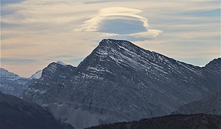
Mount Assiniboine, also known as Assiniboine Mountain, is a pyramidal peak mountain on the Great Divide, on the British Columbia/Alberta border in Canada.

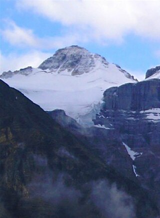
Mount Columbia is a mountain located in the Winston Churchill Range of the Rocky Mountains. It is the highest point in Alberta, Canada, and is second only to Mount Robson for height and topographical prominence in the Canadian Rockies. It is located on the border between Alberta and British Columbia on the northern edge of the Columbia Icefield. Its highest point, however, lies within Jasper National Park in Alberta.

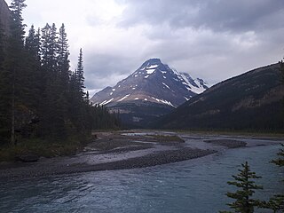
Mount Bryce is a mountain at the southwestern corner of the Columbia Icefield, in British Columbia, Canada, near the border with Alberta. It can be seen from the Icefields Parkway.
Simpson Pass, el. 2,107 m (6,913 ft), is a mountain pass on the border between the Canadian provinces of Alberta and British Columbia, in the area of the Ball Range. It is the prominence col for Mount Ball on the Continental Divide in the vicinity of Sunshine Village ski resort. Simpson River and Simpson Pass are named after Sir George Simpson who first explored the area in 1841.
Mount Bishop is a mountain named in 1918 after W.A. "Billy" Bishop VC who was a Colonel and a Canadian fighter pilot awarded the Victoria Cross during World War I. It is located in the Elk Range of the Canadian Rockies and sits on the Continental Divide, which forms the British Columbia-Alberta border in this area.
Mount Côté is located on the border of Alberta and British Columbia. The mountain is named for Jean Côté, a Canadian politician.
Mount Talbot is located on the northern side of Shale Pass on the Alberta-British Columbia border. It was officially named on 4 November 1925 after Senator Peter Talbot (1854-1919), an early pioneer of the Lacombe region of central Alberta. A teacher and farmer, he turned to politics and became an elected representative of the Northwest Territories and later the province of Alberta. In 1906, Sir Wilfrid Laurier appointed him to the Senate of Canada.
Mount Bess is located on the border of Alberta and British Columbia. It is the 83rd highest peak in Alberta. It was named in 1910 by J. Norman Collie after Bessie Gunn, who accompanied Collie's expedition.

Mount Fraser is a mountain located on the border of Alberta and British Columbia. It is Alberta's 38th highest peak and Alberta's 22nd most prominent mountain. It is also British Columbia's 50th highest peak. It was named in 1917 after Simon Fraser.
Mount Scott is located on the border of Alberta and British Columbia, North of the Hooker Icefield in Hamber Provincial Park. It is Alberta's 44th highest peak, and Alberta's 46th most prominence mountain. It is also British Columbia's 57th highest peak. It was named in 1913 after Captain Robert Falcon Scott.
Mount Hooker is located on the border of Alberta and British Columbia, Canada. It was named in 1827 by David Douglas after William Jackson Hooker. Until the turn of the century, Mount Hooker and the nearby Mount Brown were thought to be the highest mountains in the Canadian Rockies.
Mount Conway is a mountain located on the border of Alberta and British Columbia. It was named in 1901 by J. Norman Collie after Martin Conway, an alpinist.
Mount Bulyea is located in Banff National Park on the border of Alberta and British Columbia. It was named in 1920 after Hon. George H. V. Bulyea, a Canadian Pacific Railway employee and first Lieutenant Governor of Alberta.
Mount Barnard is located on the border of Alberta and British Columbia, NW of the head of Waitabit Creek and North of Golden. It is the 30th highest peak in Alberta and the 42nd highest peak in British Columbia. It was named in 1917 by boundary surveyors after Sir Francis Stillman Barnard, a Lieutenant Governor of BC during the 1910s. It should not be confused with the higher Californian peak of the same name.
Mount Trutch is a mountain located on the border of Alberta and British Columbia, Canada. It was named in 1920 after Sir Joseph Trutch, a Canadian politician who was the first Lieutenant Governor of British Columbia.
Mount Little is situated at the northern end of Kootenay National Park, and straddles the Continental Divide marking the Alberta-British Columbia border. It was named in 1916 after George F. Little, a member of the first ascent party.

Mount Cautley is located on the border of Alberta and British Columbia on the Continental Divide, SE of Assiniboine Pass. Richard W. Cautley was a surveyor from Ipswich, England. As part of the Alberta/British Columbia Boundary Commission, his party was in charge of mapping precise boundaries in the usable mountain passes of the Canadian Rockies.
A mountain formerly known as Mount Pétain, but with no current official name, is located on the border of the Canadian provinces of Alberta and British Columbia (BC) on the Continental Divide.

Mount Loomis is located on the border of Alberta and British Columbia on the Continental Divide. It was named in 1918 after Frederick Oscar Warren Loomis, a Canadian Army general who served in World War I.


