
Mount Ball is a mountain located on the Continental Divide, on the borders of Banff and Kootenay national parks in Western Canada. Mt. Ball is the highest peak of the Ball Range in the Canadian Rockies.

Lacombe is a city in central Alberta, Canada. It is located approximately 25 kilometres (16 mi) north of Red Deer, the nearest major city, and 125 kilometres (78 mi) south of Edmonton, the nearest metropolitan area. The city is set in the rolling parkland of central Alberta, between the Rocky Mountains foothills to the west and the flatter Alberta prairie to the east.

Mount Saskatchewan is a mountain located in the North Saskatchewan River valley of Banff National Park, in the Canadian Rockies of Alberta, Canada.

The Rainbow Range is a small subrange of the Park Ranges subdivisions of the Northern Continental Ranges of the Rocky Mountains on the border between Alberta and British Columbia in Mount Robson Provincial Park.
The Muddywater River is an early tributary of the Smoky River. It forms in the Canadian Rockies, within Willmore Wilderness Park, in the province of Alberta, north of Jasper National Park. The Muddywater forms at Morkill Pass, on the Continental Divide between Alberta and British Columbia.

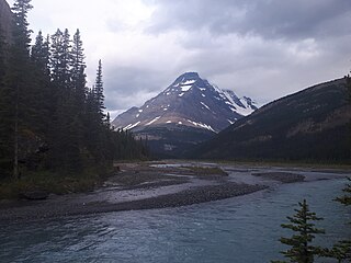
The Snaring River is a medium-sized river in the Canadian Rockies. It runs through parts of Jasper National Park in Alberta, Canada. The Snaring River is a significant tributary of the Athabasca River. The Snaring is named after a former local tribe of first nations people who lived in dugouts and trapped animals with snares.

The Astoria River is a short river in Jasper National Park, Alberta, Canada. It is an early tributary of the Athabasca River.
Mount Côté is located on the border of Alberta and British Columbia. The mountain is named for Jean Côté, a Canadian politician.
Mount Bess is located on the border of Alberta and British Columbia. It is the 83rd highest peak in Alberta. It was named in 1910 by J. Norman Collie after Bessie Gunn, who accompanied Collie's expedition.
Mount Conway is a mountain located on the border of Alberta and British Columbia. It was named in 1901 by J. Norman Collie after Martin Conway, an alpinist.
Mount Bulyea is located in Banff National Park on the border of Alberta and British Columbia. It was named in 1920 after Hon. George H. V. Bulyea, a Canadian Pacific Railway employee and first Lieutenant Governor of Alberta.
Mount Barnard is located on the border of Alberta and British Columbia, NW of the head of Waitabit Creek and North of Golden. It is the 30th highest peak in Alberta and the 42nd highest peak in British Columbia. It was named in 1917 by boundary surveyors after Sir Francis Stillman Barnard, a Lieutenant Governor of BC during the 1910s. It should not be confused with the higher Californian peak of the same name.
Mount Trutch is a mountain located on the border of Alberta and British Columbia, Canada. It was named in 1920 after Sir Joseph Trutch, a Canadian politician who was the first Lieutenant Governor of British Columbia.

Mount Beatty is a mountain located on the border of Alberta and British Columbia on the Continental Divide. It was named in 1924 after David Beatty, a British naval officer of Irish ancestry who commanded ships in the First World War.
A mountain formerly known as Mount Pétain, but with no current official name, is located on the border of the Canadian provinces of Alberta and British Columbia (BC) on the Continental Divide.

Mount Sparrowhawk is a 3,121-metre (10,240 ft) mountain summit located in Kananaskis Country in the Canadian Rockies of Alberta, Canada. Mount Sparrowhawk's nearest higher peak is Mount Bogart, 3.6 km (2.2 mi) to the southeast. Sparrowhawk's south slope was a candidate to be used as a ski hill for the alpine events at the 1988 Winter Olympics, but nearby Mount Allan's Nakiska was selected instead.

Mount Shark is a 2,786-metre (9,140-foot) mountain summit located in the Spray Valley of Kananaskis Country at the northern tip of the Spray Mountains range. It is situated on the southern boundary of Banff National Park in the Canadian Rockies of Alberta, Canada. Mount Shark in not visible from any road in Banff Park, however, it can be seen from Alberta Highway 742, also known as the Smith-Dorrien/Spray Trail. Mount Shark's nearest higher peak is Mount Smuts, 3.0 km (1.9 mi) to the southeast.

Chinook Peak is a 2,591-metre (8,501-foot) mountain summit located in the Canadian Rockies of Alberta, Canada.

Mount Tecumseh is a 2,547-metre-high (8,356 ft) mountain summit located in the Canadian Rockies of Alberta, Canada.

Blackhorn Peak is a 3,000-metre (9,800-foot) summit in Alberta, Canada.


