New Castle, New Hampshire | |
---|---|
Coordinates: 43°04′20″N70°42′58″W / 43.07222°N 70.71611°W | |
Country | United States |
State | New Hampshire |
County | Rockingham |
Incorporated | May 30, 1693 [1] |
Government | |
• Select Board |
|
• Town Administrator | Michael Tully |
Area | |
• Total | 2.27 sq mi (5.88 km2) |
• Land | 0.81 sq mi (2.09 km2) |
• Water | 1.46 sq mi (3.78 km2) 64.4% |
Elevation | 30 ft (9 m) |
Population (2020) | |
• Total | 1,000 |
• Density | 1,237/sq mi (477.5/km2) |
Time zone | UTC-5 (Eastern) |
• Summer (DST) | UTC-4 (Eastern) |
ZIP code | 03854 |
Area code | 603 |
FIPS code | 33-50980 |
GNIS feature ID | 0873676 |
Website | www |
New Castle is a town in Rockingham County, New Hampshire, United States. The population was 1,000 at the 2020 census. [4] It is the easternmost town in New Hampshire and the smallest by area, and it is the only town in the state located entirely on islands. It is home to Fort Constitution Historic Site, Fort Stark Historic Site, and the New Castle Common, a 31-acre (13 ha) recreation area on the Atlantic Ocean. New Castle is also home to a United States Coast Guard station, as well as the historic Wentworth by the Sea hotel.
The main island on which the town sits is the largest of several at the mouth of the Piscataqua River and was originally called "Great Island". Settled in 1623, an earthwork defense was built on Fort Point which would evolve into Fort William and Mary (rebuilt in 1808 as Fort Constitution). Chartered in 1679 as a parish of Portsmouth, it was incorporated on May 30, 1693, and was named "New Castle" after the fort. Until 1719 it included Rye, then called "Sandy Beach", which was set off as a parish. The principal industries were trade, tavern-keeping, and fishing. There was also agriculture, using the abundant seaweed as fertilizer. [5] : 594–6
Beginning on June 11, 1682, Great Island experienced a supernatural event—a lithobolia, or "Stone-Throwing Devil", recorded in a 1698 London pamphlet by Richard Chamberlain. On a Sunday night at about 10 o'clock, the tavern home of George Walton, an early settler and planter, was showered with stones thrown "by an invisible hand". Windows were smashed, and the spit in the fireplace leapt into the air, then came down with its point stuck in the back log. When a member of the household retrieved the spit, it flew out the window of its own accord. The gate outside was discovered off its hinges. [6] [7] : 7–12, 66–67 Rev. Cotton Mather took an interest in the phenomenon, reporting that:
The "Stone-Throwing Devil" created quite a sensation on Great Island. Hundreds of stones mysteriously rained down on George Walton's tavern, as well as onto him and others in the area over the entire summer. Yet no one ever came forward who saw anyone throwing the stones. Many other mysterious events also occurred at that time. Demonic voices were heard, and items were flung about inside Walton's tavern. Prominent Boston minister Increase Mather described the strange events in his book Illustrious Providences. [7] : xiii, 4–5, 7–12
George Walton, who was in a property boundary dispute with his neighbor, accused her of witchcraft. She, in turn, accused him of being a wizard. Others in the area may also have had reasons to throw stones at Walton. He was a Quaker. Quakers were looked upon with great suspicion by Puritans, and just being a Quaker was a crime. Walton was a successful innkeeper, merchant, and lumberman, and became the largest landowner on the island. Walton was envied by his less industrious neighbors. He was involved in a number of lawsuits over business and property disputes. He also had two Native American employees, which would have caused great concern so soon after war with the Indians (King Philip's War) and because of the uneasy peace that existed. His tavern customers included a variety of rowdy outsiders, including "godless" fishermen, who were considered undesirables by others on the island. Regardless of what caused Walton and his inn to be the victim of a months-long rain of stones, it was the first major outbreak of apparent witchcraft in America. [6] [7] : 4–5, 7–12, 48–51, 58, 66
News of it traveled throughout America and England. Within a few years, accusations of witchcraft would occur in other New England towns, culminating in the famous witch trials in Salem, Massachusetts. [7] : 177–201
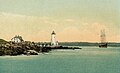
Fort William and Mary was the site of one of the first acts of the American Revolution. On the afternoon of December 14, 1774, colonists arrived aboard gundalows (sailing barges) and raided the fort. Severely outnumbered, Captain John Cochran and the fort's five soldiers surrendered, whereupon the rebels loaded onto a boat 100 barrels of gunpowder. The boat was floated up the Piscataqua River and the powder offloaded for transport to inland towns, including Durham, where the ammunition was stored in the cellar of the Congregational church. The next day, the colonists returned to the fort and removed 16 of the lighter cannon and all small arms. The gunpowder was used at the 1775 Battle of Bunker Hill. [5] : 474–477
A new route to the island was created in 1821 when three bridges (now two bridges and a causeway) connected Frame Point in Portsmouth with the northwestern corner of Great Island. Previously, a bridge on the southwestern point had been the only way to reach New Castle without a boat. The community was then an overlooked fishing village, which helped preserve its colonial architecture. However, in 1874 the Hotel Wentworth was built atop a hill with a view of Little Harbor and the ocean. After early financial difficulties, the establishment was purchased and elaborately refurbished in Second Empire style by Portsmouth alemaker and hotelier Frank Jones. It became the area's most fashionable resort, growing in size until it was a village unto itself. When President Theodore Roosevelt mediated the 1905 Treaty of Portsmouth to end the Russo-Japanese War, envoys from both countries stayed at the Wentworth by the Sea, ferried by launch to negotiations held at the Portsmouth Naval Shipyard. The hotel was a setting for the 1999 movie, In Dreams .
According to the United States Census Bureau, the town has a total area of 2.3 square miles (5.9 km2), of which 0.81 square miles (2.1 km2) are land and 1.5 square miles (3.8 km2) are water, comprising 64.4% of the town. [2] New Castle occupies an archipelago, consisting of one main island (Great Island) and several smaller islands surrounded by the Piscataqua River and Atlantic Ocean. The main channel of the Piscataqua passes around the north and east sides of Great Island, while Little Harbor is to the south and the smaller islands within Portsmouth Harbor are to the west. The southeastern end of the island, at Fort Stark, faces the Atlantic. The highest point of land is at the Wentworth by the Sea hotel, where the elevation reaches 60 feet (18 m) above sea level.
Census | Pop. | Note | %± |
---|---|---|---|
1790 | 534 | — | |
1800 | 524 | −1.9% | |
1810 | 592 | 13.0% | |
1820 | 932 | 57.4% | |
1830 | 850 | −8.8% | |
1840 | 742 | −12.7% | |
1850 | 891 | 20.1% | |
1860 | 692 | −22.3% | |
1870 | 667 | −3.6% | |
1880 | 610 | −8.5% | |
1890 | 488 | −20.0% | |
1900 | 581 | 19.1% | |
1910 | 624 | 7.4% | |
1920 | 728 | 16.7% | |
1930 | 378 | −48.1% | |
1940 | 542 | 43.4% | |
1950 | 583 | 7.6% | |
1960 | 823 | 41.2% | |
1970 | 975 | 18.5% | |
1980 | 936 | −4.0% | |
1990 | 840 | −10.3% | |
2000 | 1,010 | 20.2% | |
2010 | 968 | −4.2% | |
2020 | 1,000 | 3.3% | |
U.S. Decennial Census [8] |
As of the census of 2020, [4] there were 1,000 people in 436 households within the town. The population density was 1,250 inhabitants per square mile (480/km2). There were 525 housing units at an average density of 656.3 per square mile (253.4/km2). The racial makeup of the town was 94.9% White, 0.4% African American, 0.9% Asian, and 3.6% from two or more races. Hispanic or Latino of any race were 2.7% of the population.
At the 2010 census, 22.1% of households had children under the age of 18 living with them, 61.6% were married couples living together, 5.0% had a female householder with no husband present, and 29.1% were non-families. 23.9% of all households were made up of individuals, and 11.5% had someone living alone who was 65 years of age or older. The average household size was 2.26 and the average family size was 2.65.
In the town, the population was spread out, with 17.8% under the age of 18, 3.4% from 18 to 24, 20.8% from 25 to 44, 34.0% from 45 to 64, and 24.1% who were 65 years of age or older. The median age was 50 years. For every 100 females, there were 95.7 males. For every 100 females age 18 and over, there were 97.1 males.
The median income for a household in the town was $83,708, and the median income for a family was $93,290. Males had a median income of $57,375 versus $35,568 for females. The per capita income for the town was $67,695. None of the families and 0.6% of the population were living below the poverty line, including none under 18 and none of those over 65. New Castle was New Hampshire's wealthiest town in terms of per capita income.
Portsmouth is a city in Rockingham County, New Hampshire, United States. At the 2020 census it had a population of 21,956. A historic seaport and popular summer tourist destination on the Piscataqua River bordering the state of Maine, Portsmouth was formerly the home of the Strategic Air Command's Pease Air Force Base, since converted to Portsmouth International Airport at Pease.
Eliot is a town in York County, Maine, United States. Originally settled in 1623, it was formerly a part of Kittery, to its east. After Kittery, it is the next most southern town in the state of Maine, lying on the Piscataqua River across from Portsmouth and Newington, New Hampshire. The population was 6,717 at the 2020 census. It is part of the Portland–South Portland–Biddeford, Maine metropolitan statistical area.
Kittery Point is a census-designated place (CDP) in the town of Kittery, York County, Maine, United States. First settled in 1623, Kittery Point traces its history to the first seafarers who colonized the shore of what became Massachusetts Bay Colony and later the State of Maine. Located beside the Atlantic Ocean, it is home to Fort McClary State Historic Site, and Fort Foster Park on Gerrish Island. Cutts Island is home to Seapoint Beach and the Brave Boat Harbor Division of the Rachel Carson National Wildlife Refuge.
Sanbornton is a town in Belknap County, New Hampshire, United States. The population was 3,026 at the 2020 census. It includes the villages of North Sanbornton and Gaza.
Wakefield is a town in Carroll County, New Hampshire, United States. The population was 5,201 at the 2020 census. The town includes the villages of Wakefield Corner, East Wakefield, North Wakefield, Sanbornville, Union, Woodman and Province Lake. Wakefield Corner, popular with tourists, is a picturesque hilltop village of antique buildings. The state of Maine forms the eastern border of Wakefield.
Chesterfield is a town in Cheshire County, New Hampshire, United States. The population was 3,552 at the 2020 census. It includes the villages of Spofford and West Chesterfield. Chesterfield is home to Spofford Lake, Chesterfield Gorge Natural Area, and parts of Pisgah State Park and Wantastiquet Mountain State Forest.
Epsom is a town in Merrimack County, New Hampshire, United States. The population was 4,834 at the 2020 census.
Deerfield is a town in Rockingham County, New Hampshire, United States. The population was 4,855 at the 2020 census, up from 4,280 in 2010. Deerfield is the location of the annual Deerfield Fair.
Fremont is a town in Rockingham County, New Hampshire, United States. The population was 4,739 at the 2020 census, up from 4,283 at the 2010 census. Fremont is crossed by the Rockingham Recreation Trail and NH Route 107.
Hampstead is a town in Rockingham County, New Hampshire, United States. The population was 8,998 at the 2020 census. Hampstead, which includes the village of East Hampstead, is home to a portion of the Rockingham Recreational Trail.
Newington is a town in Rockingham County, New Hampshire, United States. The population was 811 at the 2020 census. It is bounded to the west by Great Bay, to the northwest by Little Bay and to the northeast by the Piscataqua River.
North Hampton is a town in Rockingham County, New Hampshire, United States. The population was 4,538 at the 2020 census. While the majority of the town is inland, North Hampton includes a part of New Hampshire's limited Atlantic seacoast.
Northwood is a town in Rockingham County, New Hampshire, United States. The population was 4,641 at the 2020 census.
Rye is a town in Rockingham County, New Hampshire, United States. The population was 5,543 at the 2020 census. The town is home to several state parks along the Atlantic coastline.
Stratham is a town in Rockingham County, New Hampshire, United States. The town had a population of 7,669 at the 2020 census. It is bounded on the west by the Squamscott River. The town is the home of the only U.S. Lindt & Sprüngli factory and the headquarters of the Timberland Corporation.
Middleton is a town in Strafford County, New Hampshire, United States. The population was 1,823 at the 2020 census.
Kittery is a town in York County, Maine, United States, and the oldest incorporated town in Maine. Home to the Portsmouth Naval Shipyard on Seavey's Island, Kittery includes Badger's Island, the seaside district of Kittery Point, and part of the Isles of Shoals. The southernmost town in the state, it is a tourist destination known for its many outlet stores.
Farmington is a town in Strafford County, New Hampshire, United States. The population was 6,722 at the 2020 census. Farmington is home to Blue Job State Forest, the Tebbetts Hill Reservation, and Baxter Lake.
Lithobolia: or, the Stone-Throwing Devil is a 7,000-word narrative folk tale by Richard Chamberlayne first printed in London in 1698. It is considered an early example of esoteric literature and supernatural horror writing, and has been compared to modern poltergeist stories.
Wentworth–Coolidge Mansion is a 40-room clapboard house which was built as the home, offices and working farm of colonial Governor Benning Wentworth of New Hampshire. It is located on the water at 375 Little Harbor Road, about two miles southeast of the center of Portsmouth. It is one of the few royal governors' residences to survive almost unchanged. The site is a New Hampshire state park, declared a National Historic Landmark in 1968. Today, the New Hampshire Bureau of Historic Sites manages the site with the assistance of the Wentworth-Coolidge Commission, a group of volunteer civic and business leaders appointed by the Governor.
coolidge mansfield history description new england 1859.